Terrat
| Terrat | |
|---|---|
| Ward and village | |
|
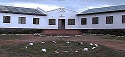
Ilaramatak Lorkonerei building in Terrat | |
 Terrat | |
| Coordinates: 3°52′S 36°36′E / 3.867°S 36.600°E | |
| Country |
|
| Region | Manyara Region |
| District | Simanjiro |
| Time zone | EAT (UTC+3) |
Terrat is a ward and village in the Simanjiro district about 80 km from Arusha in Tanzania. The ward has approximately 14,000 inhabitants.[1] The population in the area is Maasai who regularly gather in the village for its market where animals, cloths, kitchen utensils etc. are sold. The buildings in the village are one-storeyed, mostly cement walled with corrugated iron roofs, scattered at the banks of a small river.
Conservation
Terrat lies in the Simanjiro Plains, an important wet-season grazing area between Tarangire National Park and Mount Kilimanjaro. Expanding crop production has come in conflict with wildlife, leading to government restrictions on cultivation in the plains.[2]
Terrat has been at the center of the Simanjiro Conservation Easement, a novel payment for ecosystem services scheme, since 2008. This contractual agreement between the village and a consortium of tourism vendors obligates villagers to forgo agricultural activities in some areas in return for annual cash payments of 5 million Tanzanian shillings (US$3000 or €2300 as of January 2013).[3][4]
Development projects
The NGO Ilaramatak Lorkonerei has a variety of activities in the village. One project is an FM radio station Orkonerei FM Radio Service, broadcasting primarily in Maa and Swahili. The radio station went on air in 2003 and is partly funded by the Swedish International Development Cooperation Agency.[5] In 2009 the group began building a Jatropha-fired electrical power plant in Terrat. The project was funded by the Netherlands.[6]
Notes
References
- Government of Tanzania. Simanjiro District Homepage for the 2002 Tanzania National Census
- SIDA. Development Cooperation for Democracy and Social Development
- Juma, Musa (2009-06-06). "Simanjiro to produce own power using jatropha". The Arusha times. Arusha, TZ. p. 2. ISSN 0856-6135. Retrieved 2013-01-24.
- Bruder, Jessica (2011-05-22). "Into the Bush, With a Lighter Footprint". The New York Times. p. 8. ISSN 0362-4331. Retrieved 2013-01-24.
- Nelson, Fred; Charles Foley; Lara S. Foley; Abraham Leposo; Edward Loured David Peterson; Mike Peterson; Thad Peterson; Hassan Sachedina; Andrew Williams (2010-02-01). "Payments for Ecosystem Services as a Framework for Community-Based Conservation in Northern Tanzania" (PDF). Conservation Biology. 24 (1): 78–85. doi:10.2307/40419632. ISSN 0888-8892. Retrieved 2013-01-24.
- Baird, Timothy D.; Paul W. Leslie; J. Terrence McCabe (2009-08-01). "The Effect of Wildlife Conservation on Local Perceptions of Risk and Behavioral Response". Human Ecology. 37 (4): 463–474. doi:10.2307/40343988. ISSN 0300-7839. JSTOR 40343988.
Coordinates: 3°52′S 36°36′E / 3.867°S 36.600°E
