Territorial evolution of California

An enlargeable map of the United States after the Treaty of Paris in 1789
The following timeline traces the territorial evolution of the U.S. State of California.
Timeline

An enlargeable map of the United States after the Adams-Onís Treaty took effect in 1821
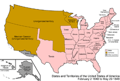
An enlargeable map of the United States after the Treaty of Guadalupe Hidalgo in 1848

An enlargeable map of the United States after the Compromise of 1850
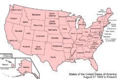
An enlargeable map of the United States as it has been since 1959
- Historical territorial claims of Spain in the present State of California:
- Las Californias, 1768–1804
- Gran Cuenca (Great Basin), 1776–1821
- Alta California, 1804–1821
- Adams-Onis Treaty of 1819
- Treaty of Córdoba of 1821
- Historical territorial claims of Mexico in the present State of California:
- Alta California, 1821–1848
- Gran Cuenca (Great Basin), 1821–1848
- Mexican-American War, 1846–1848
- California Republic, 1846
- U.S. military government of California, 1846–1849
- Treaty of Guadalupe Hidalgo of 1848
- Mexican-American War, 1846–1848
- Historical political divisions of the United States in the present State of California:
- Unorganized territory created by the Treaty of Guadalupe Hidalgo, 1848–1850
- State of Deseret (extralegal), 1849–1850
- Provisional government of California, 1849–1850
- State of California since 1850
- California Statehood Act, September 9, 1850[1]
See also
References
- ↑ Thirty-first United States Congress (September 9, 1850). "An Act for the Admission of the State of California into the Union" (cgi-bin). Retrieved June 5, 2009.
External links
This article is issued from Wikipedia - version of the 12/14/2014. The text is available under the Creative Commons Attribution/Share Alike but additional terms may apply for the media files.