Torrens, Australian Capital Territory
| Torrens Canberra, Australian Capital Territory | |||||||||||||
|---|---|---|---|---|---|---|---|---|---|---|---|---|---|
 | |||||||||||||
| Population | 2,285 (2011 census)[1] | ||||||||||||
| • Density | 1,760/km2 (4,550/sq mi) | ||||||||||||
| Established | 1966 | ||||||||||||
| Postcode(s) | 2607 | ||||||||||||
| Area | 1.3 km2 (0.5 sq mi) | ||||||||||||
| District | Woden Valley | ||||||||||||
| Territory electorate(s) | Murrumbidgee | ||||||||||||
| Federal Division(s) | Canberra | ||||||||||||
| |||||||||||||
Torrens (postcode 2607) is a suburb in the Woden Valley district of Canberra, Australia.


It is located along the district's southern edge. The suburb is named after Sir Robert Torrens, a former Premier of South Australia. The suburb was gazetted on 12 May 1966. Streets in Torrens are named after South Australian pioneers.[2]
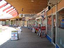
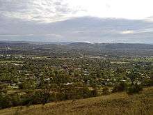
Torrens adjoins the suburbs of Pearce, Mawson and Farrer. It is bounded by Beasley Street to the north, Athllon Drive to the east, and the Canberra Nature Park to the south. To the west the skyline is dominated by the Mount Taylor nature reserve. The suburb contains a small shopping centre, a neighbourhood oval, and Torrens Primary School.
Geology
Deakin Volcanics green-grey and purple rhyodacite is under the suburb, but only exposed in the south east quarter. The rest is covered by Quaternary alluvium. The south west has Deakin Volcanics green grey, purple and cream rhyolite with the corner topped off with Deakin Volcanics red-purple and green grey rhyodacite.[3]
References
- ↑ Australian Bureau of Statistics (31 October 2012). "Torrens (State Suburb)". 2011 Census QuickStats. Retrieved 9 February 2014.
- ↑ "Suburb Name search results". ACT Environment and Sustainable Development. Retrieved 9 February 2014.
- ↑ Henderson, G. A. M.; Matveev, G. (1980). Geology of Canberra, Queanbeyan and Environs (Map). 1:50000.
Coordinates: 35°22′22″S 149°05′14″E / 35.37278°S 149.08722°E