Tropical Storm Fabian (1991)
| Tropical storm (SSHWS/NWS) | |
|
Tropical Storm Fabian southwest of Cuba | |
| Formed | October 15, 1991 |
|---|---|
| Dissipated | October 16, 1991 |
| Highest winds |
1-minute sustained: 45 mph (75 km/h) |
| Lowest pressure | 1002 mbar (hPa); 29.59 inHg |
| Fatalities | None reported |
| Areas affected | Cuba, Florida |
| Part of the 1991 Atlantic hurricane season | |
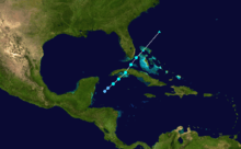
Tropical Storm Fabian was a short-lived tropical storm during the 1991 Atlantic hurricane season. The sixth named storm of the year, it formed in the northwest Caribbean southwest of Cuba. The storm reached a peak intensity of 45 mph (75 km/h), shortly before crossing over Cuba as it moved northeast past Florida. Fabian became extratropical north of the Bahamas the next day, and dissipated on October 17. Fabian caused only light rainfall along its path and there were no reported fatalities or damage.
Meteorological history

The origins of Fabian were from a tropical wave and a cold front that entered the northwestern Caribbean Sea on October 12. The two systems interacted in the Gulf of Honduras, producing convection and low atmospheric pressures. An anticyclone developed over the system, which aided in the organization of the thunderstorms.[1] At 1300 UTC on October 15, a Hurricane Hunters flight observed sustained winds of 40 mph (65 km/h) to the southwest of the Isle of Youth. Based on the report, the system was classified as Tropical Storm Fabian.[1][2] Its development was typical for an October storm in the western Caribbean. With a high pressure area to the north, there was already a large pressure gradient that had produced tropical storm force winds over the area. By the time Fabian developed a circulation, it was able to be classified as a tropical storm. However, it is possible it was a tropical depression for about 12 hours before the Hurricane Hunters report.[3]
Upon becoming a tropical storm, Fabian was disorganized and had restricted outflow.[1] An eastward moving upper-level trough imparted a northeast motion as well as unfavorable wind shear.[2] Despite the atmospheric conditions, Fabian intensified slightly to peak winds of 45 mph (75 km/h), although the strongest winds were located primarily east of the center.[4] Late on October 15, the storm moved over the Isle of Youth before crossing over western Cuba.[1] By early on October 16, the center was becoming difficult to locate on satellite imagery.[5] The storm moved through the Florida Straits, passing just southeast of the Florida mainland and into the Bahamas.[1] There was initial uncertainty whether Fabian would be absorbed by the approaching trough or maintain its separate identity.[6] By late on October 16, Fabian transitioned into an extratropical cyclone as it was absorbed into the trough.[1]
Preparations and impact

When Fabian first formed, the government of Cuba issued a tropical storm warning from Havana to Ciego de Ávila Province, as well as the Isle of Youth.[7][8] Before the storm hit the Cuban mainland, it produced wind gusts to 40 mph (65 km/h) in Cayo Largo del Sur. Its primary form of impact was from heavy rainfall in a 24‑hour period, peaking at 6.2 inches (157.5 mm) in Caonao on the south coast of Cuba. In a six-hour period, Punta del Este recorded 5 in (130 mm).[1]
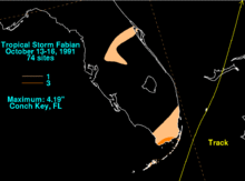
Concurrent with Fabian's first advisory, a tropical storm watch was issued for all of the Florida Keys as well as for the Bahamas.[7] The watch in the Bahamas was later upgraded to a warning.[8] Prior to the storm's passage, two state parks were closed in the Florida Keys.[9] In Dade County, Florida, a few storm shelters were opened, in anticipation that Fabian might bring flooding rains.[10] As it passed east of the state, it dropped rainfall near the coast that peaked at 4.19 in (106 mm) in Conch Key.[11] In the Florida Keys, the National Weather Service Office in Key West recorded sustained winds of 28 mph (44 km/h) with gusts to 32 mph (52 km/h). Only isolated flooding happened from the precursor system to Fabian.[9] In South Florida, Homestead Air Force Base reported rainfall of 3.68 inches (93.5 mm), but this too was attributed to the precursor frontal system, rather than Fabian itself.[10]
See also
References
- 1 2 3 4 5 6 7 Lixion Avila (1991). "Tropical Storm Fabian Preliminary Report (page 1)" (GIF). National Hurricane Center. Retrieved 2011-07-07.
- 1 2 Ed Rappaport (1991-10-15). "Tropical Storm Fabian Discussion One". National Hurricane Center. Retrieved 2011-07-07.
- ↑ Lixion Avila (1991). "Tropical Storm Fabian Preliminary Report (page 2)" (GIF). National Hurricane Center. Retrieved 2011-07-07.
- ↑ Ed Rappaport (1991-10-15). "Tropical Storm Fabian Discussion Two". National Hurricane Center. Retrieved 2011-07-07.
- ↑ Miles Lawrence (1991-10-16). "Tropical Storm Fabian Discussion Three". National Hurricane Center. Retrieved 2011-07-07.
- ↑ Max Mayfield (1991-10-16). "Tropical Storm Fabian Discussion Four". National Hurricane Center. Retrieved 2011-07-07.
- 1 2 Bob Sheets (1991-10-15). "Tropical Storm Fabian Intermediate Advisory Number 1". NOAA. Retrieved 2006-12-13.
- 1 2 Lixion Avila (1991). "Warning Summary, Tropical Storm Fabian". National Hurricane Center. Retrieved 2011-07-07.
- 1 2 Dennis Henize (WFO Key West) (1991-10-17). "Post-Storm Report - Preliminary Storm Summary: Tropical Storm Fabian". NOAA. Retrieved 2006-12-14.
- 1 2 Max White (1991-10-17). "Tropical Storm Fabian Preliminary Report". NOAA. Retrieved 2006-12-13.
- ↑ David Roth (2007-06-11). "Tropical Storm Fabian - October 13-16, 1991". Hydrometeorological Prediction Center. Retrieved 2011-07-07.
