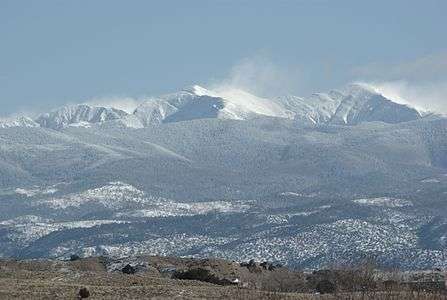
Truchas Peak
| Truchas Peak | |
|---|---|
 Truchas Peaks from Española in winter | |
| Highest point | |
| Elevation | 13,108 ft (3,995 m) NAVD 88[1] |
| Prominence | 4,001 ft (1,220 m) [2] |
| Coordinates | 35°57′45″N 105°38′42″W / 35.962525883°N 105.644964742°WCoordinates: 35°57′45″N 105°38′42″W / 35.962525883°N 105.644964742°W [1] |
| Geography | |
| Location | Rio Arriba / Mora counties, New Mexico, U.S. |
| Parent range | Sangre de Cristo Mountains |
| Topo map | USGS Truchas Peak |
| Climbing | |
| Easiest route | Scramble, class 2 |
Truchas Peak (more precisely, South Truchas Peak) is the second highest peak in the U.S. State of New Mexico behind Wheeler Peak. It is in the Sangre de Cristo Mountains 26 miles (42 km) northeast of Santa Fe. It lies within the Pecos Wilderness, part of the Santa Fe National Forest. (The north end of the mountain borders on the Carson National Forest.) The name of the peak is Spanish for "trout" (plural). It is the highest point in both Rio Arriba and Mora counties.
The entire mountain is a small north-south trending massif with four identifiable summits, North Truchas Peak, Middle Truchas Peak, "Medio Truchas Peak" (unofficial name),[3] and South Truchas Peak, the highest. Of the three subsidiary summits, only North Truchas Peak (13,029 feet or 3,971 meters) has enough topographic prominence (about 624 feet or 190 meters) to be considered an independent peak.[4]
The Truchas Peaks lie on the divide between the Rio Grande and the Pecos River. They are drained on the west by the Rio Medio, the Rio Quemado, and the Rio de las Trampas; on the northeast by the Rio Santa Barbara; and on the southeast by small creeks that quickly run into the upper reaches of the Pecos River. The massif also connects to numerous other high peaks in the region, many via the Santa Barbara Divide, a major east-west high ridge which separates the Pecos watershed on the south from the Santa Barbara watershed to the north.
The Truchas group has a true wilderness character, as it is difficult to access the peaks within a single day. Many trails access the slopes of the peaks, most notably the Skyline Trail (Trail number 251), which traverses the eastern slopes at elevation around 12,000 feet (3,660 m) and accesses the Truchas Lakes, a set of small lakes in a cirque below the south side of North Truchas Peak.
See also
- Mountain peaks of North America
- Mountain peaks of the Rocky Mountains
- Mountain peaks of the United States
- Southern Rocky Mountains
References
- 1 2 "Truchas". NGS data sheet. U.S. National Geodetic Survey. Retrieved 2014-02-14.
- ↑ "Truchas Peak, New Mexico". Peakbagger.com. Retrieved 2014-02-14.
- ↑ "Middle and Medio Truchas Peaks". SummitPost.org. Retrieved 2014-02-13.
- ↑ "North Truchas Peak, New Mexico". Peakbagger.com. Retrieved 2014-02-13.
External links
- "Truchas Peak". SummitPost.org.
- "Middle Truchas Peak, New Mexico". Peakbagger.com.
- "Medio Truchas Peak, New Mexico". Peakbagger.com.