U.S. Route 59 in Texas
| ||||
|---|---|---|---|---|
_map.svg.png) | ||||
| Route information | ||||
| Maintained by TxDOT | ||||
| Length: | 612.169 mi[1] (985.191 km) | |||
| Existed: | 1935 – present | |||
| Major junctions | ||||
| West end: | Mexico–US border in Laredo | |||
| North end: |
| |||
| Location | ||||
| Counties: | Webb, Duval, McMullan, Live Oak, Bee, Goliad, Victoria, Jackson, Wharton, Fort Bend, Harris, Montgomery, Liberty, San Jacinto, Polk, Angelina, Nacogdoches, Rusk, Shelby, Panola, Harrison, Marion, Cass, Bowie | |||
| Highway system | ||||
| ||||

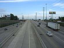

U.S. Highway 59 (US 59) in the U.S. state of Texas is named the Lloyd Bentsen Highway, after Lloyd Bentsen, former U.S. senator from Texas. In northern Houston, US 59, co-signed with Interstate 69 (I-69), is the Eastex Freeway (from Downtown Houston to the Liberty County/Montgomery County line). To the south, which is also co-signed with I-69, it is the Southwest Freeway (from Rosenberg to Downtown Houston). The stretch of the Southwest Freeway just west of The Loop was formerly one of the busiest freeways in North America, with a peak AADT of 371,000 in 1998.[2]
US 59 (overlapped by US 71) actually straddles the border between Texas and Arkansas north of I-30 near Texarkana, with the east side of the highway on the Arkansas side and the west side of the highway on the Texas side. In the past, both highways remained on the border past I-30 as State Line Avenue to downtown Texarkana; today, only US 71 does so. Nearly 90 percent of this route is designated to become part of I-69 in the future. Currently 75-mile-per-hour (121 km/h) speed limits are allowed on US 59 in Duval County and portions of northern Polk County.
The total length of the southernmost segment of US 59 that passes through Texas and terminates at the Mexico–US border is 615 miles (990 km).
History
The US 96 designation was originally applied in 1926 from Rosenberg, Texas, near Houston, to Pharr in the Rio Grande valley. This diagonal route, south of U.S. 90, did not violate the convention of even numbers for east–west routes. The highway's east–west nature was boosted in 1934 when US 96 was rerouted from Alice to Laredo.
Route description
Laredo to Interstate 37
US 59 begins at the Mexico–US border with Loop 20 on the World Trade International Bridge over the Rio Grande in Laredo. The portion of US 59 that is co-signed with Loop 20 is also named the Bob Bullock Loop. At under 2 miles, the two highways run together concurrent with I-69W from the Mexico–US border until I-35 in Laredo, where I-69W temporarily ends. US 59 and Loop 20 continue to run together until just south of Lake Casa Blanca, where Loop 20 heads south to Mangana-Hein Road and US 59 heads towards Freer; traveling in a mostly northeast direction. In Duval County, the speed limit on US 59 is 75 miles per hour, the highest speed limit on the highway. US 59 shares a short congruency with SH 44 in and around Freer. From Freer, US 59 passes through the southeastern part of McMullen County, but does not intersect any highways. The highway continues northeast, intersecting US 281 in George West, before intersecting I-37 about 55 miles north of Corpus Christi. Between Laredo and Interstate 37, US 59 passes through many rural areas and ranching sites.
Interstate 37 to Houston
From I-37, US 59 heads northeast passing through Beeville. US 59 bypasses Victoria to the south, and becomes a divided highway, and has a series of interchanges, until it becomes a freeway south of Houston in Rosenberg and resumes the designation of I-69. Between Houston and Victoria, US 59 passes through Edna, Ganado, El Campo, and Wharton. US 59 intersects many major Texas highways in Houston, including I-10 (which goes to San Antonio and Beaumont) and I-45 (which goes to Dallas and Galveston).
Houston to Marshall
Leaving Houston, US 59 intersects Beltway 8 again on the northside of town, passing by Bush Intercontinental Airport and heads into Humble. Between Houston and Livingston, most of US 59 is a limited-access freeway but the I-69 designation ends at the Montgomery-Liberty county line. US 59 passes through or bypasses the towns of Cleveland and Livingston. 46 miles north of Livingston, US 59 bypasses Lufkin, where it overlaps US 69. 10 miles north of Lufkin, US 59 bypasses Nacogdoches and heads in an almost entirely east-west direction. Drivers wishing to stay on US 59 must turn left in Tenaha, where the highway intersects US 96 and ends its overlap with US 84. US 59 passes through Carthage before intersecting I-20 south of Marshall.
Marshall to Texarkana
US 59 intersects US 80 in Marshall, where US 59 is known as East End Boulevard (due to the fact the highway runs on the east side of town, near the city limits). US 59 passes through Jefferson, 15 miles west of Caddo Lake. US 59 passes through the towns of Linden and Atlanta before arriving in Bowie County. US 59 intersects SH 93 south of Texarkana, the old highway through the city. Shortly after, I-369 designation with US 59 when the freeway intersects Spur 151, where US 59 becomes a freeway on the westside of the city. Before US 59 intersects I-30, and overlaps I-30 until exit 223B, at the state line, I-369 designation ends. After leaving I-30, US 59 joins US 71, where both highways run on the state line between Texas and Arkansas, where both highways continue north towards DeQueen, Arkansas.
Future
| |
|---|---|
| Location: | Victoria–Tenaha |
| |
|---|---|
| Location: | Laredo–Victoria |
| |
|---|---|
| Location: | Tenaha–Texarkana |
US 59 is in the process of being upgraded between Laredo & Victoria, to become I-69W, Between Victoria & Tenaha, as I-69, and Tenaha & Texarkana, I-369.
Major intersections
| County | Location | mi | km | Exit | Destinations | Notes | ||
|---|---|---|---|---|---|---|---|---|
| Webb | Laredo | World Trade Bridge over Rio Grande west end of I-69W / Loop 20 overlap | ||||||
| interchange | ||||||||
| east end of I-69W overlap; I-35 exit 8 | ||||||||
| interchange; east end of Loop 20 overlap | ||||||||
| | ||||||||
| | ||||||||
| Duval | | south end of SH 44 overlap | ||||||
| Freer | ||||||||
| | north end of SH 44 overlap | |||||||
| | ||||||||
| McMullen |
No major junctions | |||||||
| Live Oak | | |||||||
| | ||||||||
| | ||||||||
| George West | ||||||||
| | Future I-69C South | |||||||
| | south end of FM 799 overlap | |||||||
| | north end of FM 799 overlap | |||||||
| Goynes Junction | I-37 exit 56 | |||||||
| | ||||||||
| Bee | | |||||||
| | ||||||||
| Beeville | ||||||||
| interchange | ||||||||
| Goliad | Berclair | |||||||
| San Antonio River Valley Historic District | ||||||||
| | south end of SH 239 overlap | |||||||
| | ||||||||
| Goliad | north end of SH 239 overlap | |||||||
| Fannin | interchange | |||||||
| Victoria | | interchange; south end of US 77 overlap | ||||||
| | ||||||||
| | interchange; north end of US 77 overlap | |||||||
| | interchange (future I-69E south); southbound exit and northbound entrance | |||||||
| Victoria | interchange | |||||||
| interchange | ||||||||
| interchange | ||||||||
| Telferner | interchange | |||||||
| Inez | interchange; south end of freeway | |||||||
| Jackson | | interchange | ||||||
| El Toro | interchange | |||||||
| Edna | interchange | |||||||
| interchange | ||||||||
| interchange | ||||||||
| | interchange; north end of freeway | |||||||
| | interchange | |||||||
| Ganado | interchange | |||||||
| interchange | ||||||||
| Wharton | Louise | interchange; no northbound entrance | ||||||
| County Road 319 | interchange | |||||||
| interchange | ||||||||
| Hillje | interchange | |||||||
| | interchange | |||||||
| El Campo | interchange | |||||||
| interchange | ||||||||
| interchange | ||||||||
| interchange | ||||||||
| Pierce | ||||||||
| Wharton | interchange | |||||||
| interchange | ||||||||
| | interchange | |||||||
| Hungerford | interchange | |||||||
| | southbound access only | |||||||
| Fort Bend | Kendleton | interchange | ||||||
| | southbound exit only | |||||||
| | interchange | |||||||
| Beasley | Isleib Road | interchange | ||||||
| Rosenberg | southbound access only | |||||||
| interchange | ||||||||
| at-grade intersection; south end of freeway; no northbound entrance; south end of I-69 overlap | ||||||||
| see I-69 | ||||||||
| Liberty | | Fostoria Road | Montgomery County / Liberty County line; Southbound exit to Fostoria Road; North end of Freeway; North end of I-69 overlap | |||||
| | US 59 northbound exit is a left handed u-turn just north of the southbound exit; Drivers must enter onto and cross over US 59 southbound lanes in order to take the southbound exit | |||||||
| Cleveland | interchange; south end of freeway | |||||||
| interchange; north end of freeway | ||||||||
| San Jacinto | | interchange under construction | ||||||
| Shepherd | 453 | interchange; signed as exits 453A (on US 59 south) and 453B (on US 59 north) | ||||||
| 451 | interchange; signed as exit 451B (on US 59 north); no exit number southbound | |||||||
| no left turn northbound | ||||||||
| | ||||||||
| Polk | Goodrich | |||||||
| interchange | ||||||||
| Livingston | 436A-B | interchange; south end of freeway; signed as exits 436A (on US 59 south) and 436B (on US 59 north to US 59 Bus.); no exit number for US 59 north to FM 1988 | ||||||
| 436D 434B | Frontage Road | signed as exits 434B (on US 59 south) and 436D (on US 59 north) | ||||||
| 434D 432B | signed as exits 432B (on US 59 south) and 434D (on US 59 north), access to Memorial Medical Center | |||||||
| | interchange; north end of freeway; no direct northbound exit (signed at exit 434D) | |||||||
| | ||||||||
| Leggett | ||||||||
| south end of FM 942 overlap | ||||||||
| north end of FM 942 overlap | ||||||||
| | ||||||||
| Moscow | ||||||||
| Corrigan | ||||||||
| | ||||||||
| Angelina | Diboll | |||||||
| | ||||||||
| | ||||||||
| Lufkin | ||||||||
| 391 | interchange; south end of freeway | |||||||
| south end of Loop 287 overlap; US 59 north follows exit 390; access to FM 1877, access to Woodland Heights Medical Center | ||||||||
| Tulane Drive | no direct northbound exit | |||||||
| interchange; north end of freeway | ||||||||
| interchange; south end of US 69 overlap | ||||||||
| interchange | ||||||||
| interchange; no direct northbound exit (signed at FM 841) | ||||||||
| interchange | ||||||||
| interchange; north end of US 69 / Loop 287 overlap; access to FM 2021 west and FM 3521 east | ||||||||
| | ||||||||
| Redland | ||||||||
| | ||||||||
| Nacogdoches | | |||||||
| Nacogdoches | interchange; south end of Loop 224 overlap; US 59 south follows exit 59S | |||||||
| interchange | ||||||||
| interchange | ||||||||
| interchange | ||||||||
| northbound access only | ||||||||
| interchange | ||||||||
| interchange; north end of Loop 224 overlap | ||||||||
| interchange | ||||||||
| Redfield | interchange | |||||||
| | ||||||||
| Appleby | ||||||||
| | ||||||||
| Fitze | ||||||||
| Garrison | south end of FM 95 overlap | |||||||
| north end of FM 95 overlap | ||||||||
| Rusk |
No major junctions | |||||||
| Shelby | | |||||||
| Timpson | south end of US 84 overlap | |||||||
| | ||||||||
| Tenaha | ||||||||
| south end of FM 947 overlap | ||||||||
| north end of FM 947 overlap | ||||||||
| interchange; north end of US 84 overlap. South End of Future I-369 overlap. US 84 to the east will be upgraded to I-69. | ||||||||
| Panola | Shady Grove | |||||||
| Pleasant Ridge | ||||||||
| | interchange | |||||||
| Carthage | ||||||||
| interchange; south end of US 79 overlap | ||||||||
| | interchange; north end of US 79 overlap | |||||||
| | ||||||||
| | ||||||||
| | ||||||||
| Harrison | | |||||||
| | ||||||||
| | ||||||||
| Marshall | I-20 exit 617 | |||||||
| south end of SH 43 overlap | ||||||||
| north end of SH 43 overlap | ||||||||
| | ||||||||
| Woodlawn | ||||||||
| Marion | | |||||||
| Jefferson | ||||||||
| | ||||||||
| Cass | Pruitt | |||||||
| Linden | ||||||||
| | south end of FM 2328 overlap | |||||||
| | north end of FM 2328 overlap | |||||||
| Atlanta | south end of SH 77 overlap | |||||||
| north end of SH 77 overlap | ||||||||
| Queen City | ||||||||
| Lanark | ||||||||
| | ||||||||
| | interchange under construction | |||||||
| Bowie | | |||||||
| | ||||||||
| | ||||||||
| Eylau | ||||||||
| Texarkana | interchange; south end of I-369 overlap. North End of Future I-369 overlap. | |||||||
| see I-369 | ||||||||
| north end of I-369 overlap; south end of I-30 overlap; US 59 south follows exit 220A | ||||||||
| 220B | ||||||||
| 222 | ||||||||
| Arkansas state line; north end of I-30 overlap; south end of US 71 overlap; US 59 north follows exit 223 | ||||||||
| 1.000 mi = 1.609 km; 1.000 km = 0.621 mi | ||||||||
References
- ↑ Transportation Planning and Programming Division (n.d.). "U.S. Highway No. 59". Highway Designation Files. Texas Department of Transportation. Retrieved 2007-09-08.
- ↑ "TexasFreeway > Houston > Photo Gallery > US 59 > The Southwest Freeway". www.texasfreeway.com. Retrieved 2016-09-30.
| Previous state: Terminus |
Texas | Next state: Arkansas |