Villamelendro de Valdavia
Coordinates: 42°32′15″N 04°34′22″W / 42.53750°N 4.57278°W / 42.53750; -4.57278
Villamelendro is a hamlet of Villasila de Valdavia in the Vega-Valdavia region. Located in the transitional space between Montaña Palentina and Tierra de Campos in the Spanish province of Palencia (Castile and León) on the northern side of the triangle formed by Saldaña, Carrión de los Condes and Herrera de Pisuerga, 30 km to the North of the Camino de Santiago. It is located in the right margin of the River Valdavia, 0.8 km from the Provincial road "'PP-2401/a."'. Its present name first appears in a document of Emperor Charles V of the year 1537.[1]
According to the 2007 census (INE), the village has a population of 36 inhabitants.
Map of Villamelendro de Valdavia
River Valdavia crosses the village from North to South, Villamelendro is on the right bank of it.
Demographic evolution
| 2000 |
2001 |
2002 |
2003 |
2004 |
2005 |
2006 |
2007 |
2008 |
2009 |
2010 |
2011 |
| 28 |
27 |
24 |
21 |
19 |
18 |
17 |
17 |
16 |
16 |
16 |
16 |
Limits of the settlement
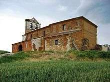
Church of Nuestra Señora de la Asunción de Villamelendro. S.XVI
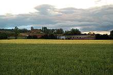
View of Villamelendro from La Vega.
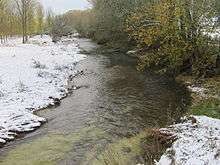
Snowy day in Valdavia river at Villamelendro de Valdavia.
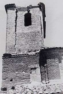
Original tower of the Church of La Asunción in Villamelendro de Valdavia built by
Juan de la Cuesta around 1580. It was rebuilt as a bell Gamble at around 1960.
Heritage
- Church of Nuestra Señora de la Asunción: work of brick, masonry and stonework, with modern tower of belfry at the foot, which replaced the old tower with hipped roof, of masonry and bricks of two pockets in the middle of the 20th century since it threatened the ruin. Cover of brick arches, preceded by a portico of two arches on the side of the epistle. By analogy with other churches in the area, this portico should consist of three arches, although it is unknown when the one on the right side is blinded.
Toponomy
Hidronomy
| Brooks |
|---|
| Boqueras, Aº. de las | Canalejas, Aº. de las | Cuérnago del Molino | Cuestamañana, Aº de | Franciscas, Aº. de las | Fuentemellada, Aº de |
| Huertas, Aº de las | Huerto Las Casas, Aº del | Lobas, Aº. de las | Majadillas, Aº. de las | Matafrades, Aº. De | Matazalce, Aº de |
| Orejo, Aº de | Quintanillas, Aº de las | Romilla, Aº de | Valdecabras, Aº de | Valdecirbano, Aº | Valdemadre, Aº de |
| Valdeodrés, Aº de |
| Fountains |
|---|
| Vega, Fuente de | Pueblo, Fuente del | Escuela, Fuente de la |
Oronomy
| Paths |
|---|
| Barriales, Cº de los | Campos, Cº de los | Fuentepedreña, Cº de | Itero Seco, Cº de | Landesa, Cº de | Otero Nombrado, Cº de |
| Palominas, Cº de las | Pepino, Cº de | Rigueras, Cº de las | S. Andrés, Cº de | Soto, Cº del | Sotobañado, Cº de |
| Camino de Dña. Olimpa, Cº | Villabasta, Cº. De | Villada, Cº de |
| Mountains |
|---|
| Corrillo, 990m | Lobas, 990m | Morcorio, 986m | Picones, Los. 985m |
| Places |
|---|
| Argañales, Los' | Arnillas, Las | Barciganillo | Camino de Villamelendro | Canalejas | Cañadillo, El |
| Corbejones, Los | Corrillo | Eras, Las | Espineras, Las | Fontecha, La | Franciscas, Las |
| Fuentemellada | Fuentepedreña | Hazas, Las | Hongares, Los | Huertas, Las | Huerto Las Casas |
| Landesa | Llanillos | Lobas, Las | Manrubial | Matafrades | Matazalce |
| Molino del Oleo | Olmos, Los | Orejo | Otero Nombrado | Pajariteros, Los | Palominas, Las |
| Payudos | Portilla, La | Quintana | Quintanas, Las | Rabas, Las | Ribero, El |
| Rigueras,Las | Romilla | Soto, El | Tras La Iglesia | Valdecirbano | Valdemadre |
| Valdeodrés |
References
Other references


