Yasothon Province
| Yasothon ยโสธร | |
|---|---|
| Province | |
 Map of Thailand highlighting Yasothon Province | |
| Country |
|
| Capital | Yasothon |
| Government | |
| • Governor | Buntham Loetsukhikasem (since October 2015) |
| Area | |
| • Total | 4,161.7 km2 (1,606.8 sq mi) |
| Area rank | Ranked 54th |
| Population (2014) | |
| • Total | 540,211[1] |
| • Rank | Ranked 44th |
| • Density rank | Ranked 29th |
| Time zone | ICT (UTC+7) |
| ISO 3166 code | TH-35 |
Yasothon (Thai: ยโสธร, pronounced [já.sǒː.tʰɔ̄ːn]) is a province (changwat) of Thailand, in the northeast on the Chi River. The province was established by the revolutionary council of Field Marshal Thanom Kittikachorn, after its Announcement No. 70 which came into force on 3 March 1972.
Neighboring provinces are (from north clockwise) Mukdahan, Amnat Charoen, Ubon Ratchathani, Sisaket, and Roi Et.
Geography
The northern part of the province are plains with low hills, while the southern part is the river lowland of the River Chi, with ponds and swamps.
Geology
Yasothon soils (rhodic ferralsols,) formed in the Triassic before the uplift of the Khorat Plateau, are relict soils made fertile by field termites through bioturbation.[2]
History
The province was created on 1 March 1972, when it was split off from Ubon Ratchathani province.
Symbols
The seal of the province shows two mythical lions, called singh, facing the chedi Pra A-non, in the temple Wat Maha That in the city of Yasothon. In the legendary account of the founding of the city, a lion came out of the forest when the site was chosen; hence the city was called Ban Singh Tha (Thai: บ้านสิงห์ท่า), Home (of) Imposing Lion. (For facts behind the legend, and of two men called Singh, see the city's history).
At the bottom of the seal is a lotus flower (Nymphaea lotus), as the lotus is both the provincial flower of the province and of Ubon Ratchathani Province, of which Yasothon was part until 1972. The provincial tree is Anisoptera costata.
Administrative divisions

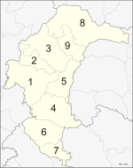
The province is divided into nine districts (amphoe). The districts are further subdivided into 78 communes (tambon) and 835 villages (muban).
Tourism
Sights
Phaya Tan Park สวนสาธารณะพญาแถน The park is surrounded by winding stream. It includes a beautiful garden, outdoor stage, playground, and health park. Phaya Tan Park is the venue for provincial fairs and festivals such as annual Rocket Festival, short boat racing, and Songkran (Thailand).
Wat Maha That. วัดมหาธาตุ The Buddhist temple is a Yasothon icon. The ancient temple houses "Phra Buddha Boonyarat" or "Phra Kaeo Yod Nam Kang", Buddha statue in attitude of meditation in Chiang Saen Art style. Attractions in Wat Maha That include:
- Phra That Yasothon or Phra That Anon. พระธาตุยโสธร หรือ พระธาตุอานนท์ A significant ancient stupa of Isan. Housing ashes of Phra Anon พระอานนท์ inside, the square based stupa has a head similar to Phra That Phanom.
- Hor Trai or Library for Buddhist scriptures. หอไตร The pavilion is used for keeping Buddhist scriptures. The rectangular pavilion has terrace around for housing the Buddhist scriptures chest board, cradles, and shelves from Vientiane. The niche and wooden door are well carved and covered with gold leaf.
- Phra That Kong Khao Noi. พระธาตุก่องข้าวน้อย Different from other monuments which are often mainly concerned with Buddhism, Phra That Kong Khao Noi was built by a commoner. Legend says that a young farmer had been working since dawn. At noon, his mother came late with his lunch. Great hunger and his anger at seeing a tiny serving of rice drove him to kill his mother. The young farmer built this stupa, hoping for forgiveness and to expiate his sin.
Ban Thung Nang Oak. บ้านทุ่งนางโอก A village famed for its bamboo basketry.
Ban Na Samai. หมู่บ้านนาสะไมย Close to Ban Thung Nang Oak, the village is famed for bamboo basketry and carved miniature carts.
The old building of Ban Singha Tha. ย่านเมืองเก่าบ้านสิงห์ท่า Ban Khum Singha Tha, in Muang municipality, is the old area whose name is found in the city's history.
Phu Tham Phra. ภูถ้ำพระ Housing Buddha statues, the cave Phu Tham Phra is 6 metres wide and 16 metres long. The shady mountain is blanketed with lush forest. Other caves in the area include Than Keng, Tham Ngu Suang, Tham Kliang, and Tham Prombutr.
Ban Song Puey Archeological Site. แหล่งโบราณสถานบ้านสงเปือย Its significant attractions include:
- Big Buddha Image. พระพุทธรูปใหญ่ Made of brick, the principal Buddha of Wat Song Puey is 3 metres wide and 8 metres high. This sacred image can be dated back more than 200 years.
- Pagodas containing soil from holy sites of Buddhism. เจดีย์บรรจุดินจากสังเวชนียสถาน The old pagoda, more than 200 years old, houses soil from a holy site of Buddha, namely the place of birth, enlightenment, the first sermon, and nirvana, brought from India by a Buddhist monk, Khien Ammaphand.
- The replica of Buddha's footprint. รอยพระพุทธบาทจำลอง The Buddha footprint was built by sponsorship of Field Marshal Plaek Pibulsongkram and his lady. Local people come to bathe the footprint during Songkran.
- Antique Museum. พิพิธภัณฑ์ของโบราณ The museum features antiques found in Dong Muang Toey, an ancient Khmer town. The antiques include the stone bed of the mayor, and stone inscriptions in ancient Khmer script.
- Dong Muang Toey Ancient town. ซากเมืองโบราณดงเมืองเตย Foundations of a temple and town wall are found here. Although they are ruined, their remains indicate that it once was settlement in the Chenla-Dhavaravadi period. Chenla King's inscription indicates that this ancient site was religious site for Shaivism.
- Ku Chan. กู่จาน is an ancient pagoda similar to that of Wat Phra That Phanom. Legend says it was built in the same period to Phra That Phanom in That Phanom District, Nakhon Phanom Province.
- Yasothon Buddha footprint. พระพุทธบาทยโสธร The Buddha footprint is on a white sandy hill. It is considered a sacred antique of the province. An antique found nearby is a 2-foot-wide (0.61 m) laterite Buddha image in the attitude of meditation under Nāga protection, and a laterite inscription which is a metre high and 50 centimetres wide.
- Hor Trai, or library of Wat Sra Trinurak. หอไตรวัดสระไตรนุรักษ์ The pavilion, over a century old, houses Buddhist scriptures. The Burmese-style wooden architecture is 8.3 metres wide and 10.5 metres long, with 4-level metal-sheet roof and long eaves at all sides.
Church of the Archangel Michael Ban Songyae Catholic Churchม โบสถ์คริสต์บ้านซ่งแย้ Amphoe Thai Charoen อำเภอไทยเจริญ The church serves Catholic villagers and also has a school for those of all faiths. The church was founded in 1908. The present structure, built in 1947 of wood contributed by villagers, is the fourth church. Built in Thai traditional style, the country's biggest wooden church is 16 metres wide and 57 metres long. Signs direct visitors from Highway 2169.
Local products

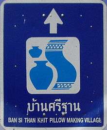
Khit Pillow at Ban Sri Than. หมู่บ้านทำหมอนขิดบ้านศรีฐาน The village is known for khit pillows, local-style pillows with beautiful patterns. After harvest, most villagers earn extra income by producing khit pillows.
Culture
Festivals
Rocket Festival (Thai: งานประเพณีบุญบั้งไฟ) - Yasothon is famous for its Rocket Festival, held every year in May. Originally a fertility rite, it has become the major festival of the year in the region. The festival is held on every second weekend of May at Phaya Taen Park. Yasothon locals believe that the festival pleases the gods and spirits which ensure adequate rain and food.
Garland Festival (Thai: งานประเพณีแห่มาลัย) - The ancient festival of Ban Yardfah, Amphoe Maha Chana Chai, is held annually on Makha Bucha Day. Buddhists believe that on that day, the Buddha comes back from the heaven after preaching to his mother.
See also
| Wikisource has original text related to this article: |
References
- ↑ "Population of the Kingdom" (PDF). Department of Provincial Affairs (DOPA) Thailand (in Thai). 2014-12-31. Retrieved 19 Mar 2015.
- ↑ Lofjle & Kubiniok, Landform development and bioturbation on the Khorat plateau, Northeast Thailand, Nat.Hist.Bull.Siam Soc. (56), 1996
External links
 Yasothon travel guide from Wikivoyage
- Province page from the Tourist Authority of Thailand
- Website of province (Thai only)
- Yasothon provincial map, coat of arms and postal stamp
 |
Mukdahan Province |  | ||
| Roi Et Province | |
Amnat Charoen Province | ||
| ||||
| | ||||
| Sisaket Province | Ubon Ratchathani Province |
Coordinates: 15°48′8″N 104°8′23″E / 15.80222°N 104.13972°E