Unguja South Region
Coordinates: 6°16′S 39°25′E / 6.267°S 39.417°E
| Unguja South Region Mkoa wa Unguja Kusini (Swahili) | |
|---|---|
| Region | |
|
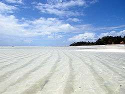
Paje beach | |
 Location in Tanzania | |
| Country | Tanzania |
| Zone | Zanzibar |
| Capital | Koani |
| Area | |
| • Total | 854 km2 (330 sq mi) |
| Population (2012) | |
| • Total | 115,588 |
| • Density | 140/km2 (350/sq mi) |
| Time zone | EAT (UTC+3) |
| Postcode | 72xxx |
| Area code(s) | 024 |
| Website |
zanzibar |
Unguja South Region is one of the thirty regions of Tanzania. Located on the island of Zanzibar, the town of Koani serves as the region's capital. As of 2002, the population was 94,504.[1]
Administrative divisions
Districts
The region is administratively divided into two districts:
| Districts of Unguja South Region | ||
|---|---|---|
| Map | District | Population (2012) |
 |
Kati District | 76,346 |
| Kusini District | 39,242 | |
| Total | 115,588 | |
Constituencies
For parliamentary elections, Tanzania is divided into constituencies. As of the 2010 elections Zanzibar Central/South Region had five constituencies:[2]
- Chwaka Constituency
- Koani Constituency
- Makunduchi Constituency
- Muyuni Constituency
- Uzini Constituency
References
- ↑ "2002 Population and Housing General Report: South Unguja". Archived from the original on 18 March 2004.
- ↑ "Organisations located in Zanzibar South Region - Tanzania". African Development Information.
External links
| Wikimedia Commons has media related to Unguja Central South Region. |
This article is issued from Wikipedia - version of the 9/5/2016. The text is available under the Creative Commons Attribution/Share Alike but additional terms may apply for the media files.
