Zoom Cyprus
|
[[File:Zo thumbnail om Logo.png|frameless|Zoom Logo]] | |
|
Screenshot of Zoom 3D Map | |
| Original author(s) | Zoom Cyprus |
|---|---|
| Initial release | June 1, 2014 |
| Stable release |
1.7.9 Monkey
/ 5 August 2014 |
| Preview release |
2 June 2014
|
| Development status | Active |
| Operating system | Android since initial release; |
| Size | 26 MB |
| Available in | English, Greek, Russian, Turkish |
| Website | http://zoomcy.com/maps |
Zoom is an interactive map viewing & GPS navigation software for offline and online maps for Cyprus. Zoom includes 3D maps, 2D maps and satellite maps, as well as functions such as a route planner for traveling on foot, by car or bicycle.
Zoom API,[1] is an application that was released by Zoom for Android on June 1, 2014. On August 5, 2014 Zoom released its current update 1.7.9 Monkey version.
Features


Zoom includes:
- Zoom Cyprus maps. Map files are sent as updates inside the application without the need for installing a new version.
- High resolution 3D maps for all city centers: Nicosia, Limassol, Larnaca, Paralimni, Agia Napa, Pafos, Pegia, Aphrodite Hills, Polis. These images are multi-directional north, east, south and west and are high resolution aerial photographs.
- 4000 confirmed Points of Interest (POI). Businesses are confirmed before being added to the application and are checked for updates.
- Addresses, telephones, websites, e-mail addresses, working hours are available for each business.
- Offline map rendering, navigation with voice guidance. Advanced options for navigation in the car, on foot or on bicycle.
- Announce speed limits and other traffic warnings like speed bumps.
Features provided in the application:[2]
Available in three languages (English, Greek and Russian)
Required Android Version: 2.1 and up
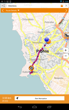
- Plan routes (directions with voice guided GPS navigation).
- Navigate (2D offline maps, high resolution 3D aerial imagery, satellite).
- Business search (business by name, category, around businesses).
- Search address.
- Save favorite locations and routes.
- Save photo and audio notes (picture, voice memo as a note).
- Save parking position.
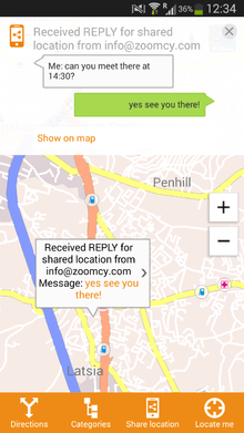
- Share location with other users, or the social networks. Send a message or get a reply with sharing location.
- Get local deals and offers.
- Download coupons to phone.
Features provided in the Online web maps:[3]
Available in three languages (English, Greek, Russian)
- Find an address or place.
- Search for a business.
- Search by coordinates.
- Get directions.
- Send locations to phone.
- Make a call: send a business number to the phone dialler.
Track And Talk[4]
Track And Talk was founded in 2005 as a leading provider of fleet management and GPS navigation advertising solutions in Cyprus.
Track and Talk signed an agreement with the Road and Transport Department on the 8th of September 2009 tender offer TOM 13.25.006.21.
On June 1, 2014 releases the Zoom Cyprus for Android.
References
- ↑ "What is the Google Maps API?".
- ↑ "Zoom Cyprus Maps". Zoom. Retrieved 15/06/14. Check date values in:
|access-date=(help) - ↑ "Zoom Cyprus Maps". Zoom. Retrieved 15/06/14. Check date values in:
|access-date=(help) - ↑ "Track and Talk". Tack and Talk. Retrieved 10/06/14. Check date values in:
|access-date=(help)
