Above All State Park
| Above All State Park | |
| Connecticut State Park | |
 | |
| Country | |
|---|---|
| State | |
| County | Litchfield |
| Town | Warren |
| Elevation | 1,470 ft (448 m) [1] |
| Coordinates | 41°43′36″N 73°21′10″W / 41.72667°N 73.35278°WCoordinates: 41°43′36″N 73°21′10″W / 41.72667°N 73.35278°W [1] |
| Area | 31 acres (13 ha) [2] |
| Established | 1927 |
| Management | Connecticut Department of Energy and Environmental Protection |
|
Location in Connecticut
| |
| Website: Above All State Park | |
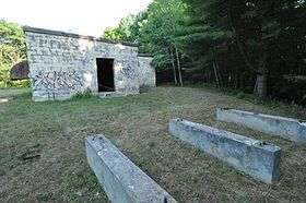
Above All State Park is an undeveloped public recreation area located in the town of Warren, Connecticut.[3] Remnants of a Cold War-era military radar installation (pictured at right) may be seen. The only park amenities are informal trails not maintained by the Connecticut Department of Energy and Environmental Protection.
History
Because of its reputation as one of the best lookouts in Litchfield County, the Above All peak was the site of a wooden observation tower in the years before the Civil War.[4] A mountain-top summer resort planned in the 1880s, that would have featured a 125-foot (38 m) observation tower for the viewing of far distant sights, never materialized.[5] The park originated in 1927 when the heirs of Seymour Strong gave three acres of land to the state.[6] The state's purchase of 28 adjoining acres from the Stanley estate followed in December 1927.[7] In 1934, the State Register and Manual identified Above All as Connecticut's 36th state park.[8]
From June 1957 to June 1968, the state park became a Semi-Automatic Ground Environment (SAGE) Air Defense Network radar site. The military installation was called the New Preston Gap-Filler RADAR Annex P-50A /Z-50A. The site was an unmanned gap-filler "providing low altitude coverage" that "consisted of the radar and tower along with the building which contained the radar equipment and a diesel generator."[9][10] In 1968, a dirt road and cinder block building were added to the top of the hill as part of an upgrade to the site.[11] In 1981, the park was the subject of a study by Northeast Utilities as a possible wind power site. An anemometer and wind vane were placed atop a 65-foot (20 m) tower to record wind data.[12]
Park name
According to the WPA writers who created Connecticut: A Guide to Its Roads, Lore, and People in the 1930s, the park's name came from its "top of the world" isolation.[13] In his book on Connecticut's state parks, Joseph Leary traces the name to the land's use by the Stone family, who claimed it was the highest working farm by elevation in all of Connecticut.[14]
Status
Accessing the park off Connecticut Route 341 requires passing a barred gate. Informal trails near the top of the park are not maintained or marked and there are no facilities.[11] Structures on the site include the radar equipment building, footings for the radar tower, and supports for the generator's fuel tank. Photos displayed on the Radome website show the condition of the site in 2001 and 2006 with the equipment building in "excellent condition," and the radar tower and chain-link fencing missing. The site has been vandalized by graffiti.[15]
References
- 1 2 "Above All State Park". Geographic Names Information System. United States Geological Survey.
- ↑ "Appendix A: List of State Parks and Forests" (PDF). State Parks and Forests: Funding. Staff Findings and Recommendations. Connecticut General Assembly. January 23, 2014. p. A-1. Retrieved September 2, 2016.
- ↑ "Above All State Park". State Parks and Forests. Connecticut Department of Energy and Environmental Protection. Retrieved February 5, 2013.
- ↑ Report of the State Park and Forest Commission to the Governor (1928). Hartford, Conn.: State of Connecticut. December 22, 1928. p. 27. Retrieved September 2, 2016.
- ↑ Bookseller Ray Boas discussing the contents of Bryan, Clark W. (1884). Through the Housatonic Vally to the Hills and Homes of Berkshire. Bridgeport, Conn.: The Housatonic Railroad. Retrieved September 3, 2016.
- ↑ "Park commission to buy 125 acres for state forest". The Day. New London, Conn. January 12, 1928. Retrieved May 19, 2014.
- ↑ "State to buy 28 acres of land on mountain". The Bridgeport Telegram. Bridgeport, Conn. December 9, 1927. p. 13. Retrieved January 1, 2015.
- ↑ "State Parks". State Register and Manual 1934. State of Connecticut. 1934. p. 227. Retrieved September 3, 2016.
- ↑ "SAGE New Preston". Coldwar-Ct.com. Retrieved May 19, 2014.
- ↑ A writer for the Connecticut Green Party has made unsubstantiated claims that the installation was a Nike missile launch site and that the existence of the park has reverted to secrecy. Bedell, David (August 2008). "Connecticut's Nuclear Weapons". Green Party of Connecticut. Retrieved March 20, 2014.
- 1 2 Leary, Joseph (2004). A Shared Landscape: A Guide & History of Connecticut's State Parks & Forests. Hartford, Conn.: Friends of the Connecticut State Parks, Inc. p. 228. ISBN 0974662909.
- ↑ "Northeast Utilities studying wind power". The Day. New London, Conn. January 17, 1981. Retrieved 19 May 2014.
- ↑ Federal Writers' Project (1938). Connecticut: A Guide to Its Roads, Lore, and People. American Guide Series. Boston: Houghton Mifflin Company. p. 455. Retrieved July 8, 2015.
- ↑ Leary opines that despite its name, the park is not "above all" in terms of scale, views or elevation and cites the scale of Lake Waramaug State Park, the views of Mount Tom State Park, and the elevation of Dennis Hill State Park. Leary, p. 228
- ↑ "Recent photos of New Preston, CT GFA". Radomes, Inc. - The Air Defense Radar Veterans Association. Retrieved May 19, 2014. The Radomes website states that the site is "not within a state park as earlier reported," then gives the same directions and site description as Leary and Bedell.
External links
| Wikimedia Commons has media related to Above All State Park. |
- Above All State Park Connecticut Department of Energy and Environmental Protection