Bakun, Benguet
| Bakun | ||
|---|---|---|
| Municipality | ||
| Municipality of Bakun | ||
| ||
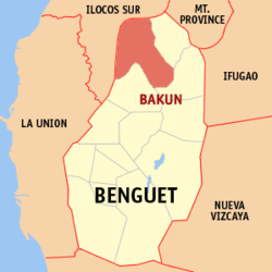
 Location in the province of Benguet | ||
.svg.png) Bakun Location within the Philippines | ||
| Coordinates: PH 16°47′32″N 120°39′55″E / 16.7922°N 120.6653°ECoordinates: PH 16°47′32″N 120°39′55″E / 16.7922°N 120.6653°E | ||
| Country | Philippines | |
| Region | Cordillera Administrative Region (CAR) | |
| Province | Benguet | |
| District | Lone district of Benguet | |
| Barangays | 7 | |
| Government | ||
| • Mayor | Fausto Talbino Labinio | |
| Area[1] | ||
| • Total | 286.91 km2 (110.78 sq mi) | |
| Population (2015 census)[2] | ||
| • Total | 15,357 | |
| • Density | 54/km2 (140/sq mi) | |
| Time zone | PST (UTC+8) | |
| ZIP code | 2610 | |
| Dialing code | +63 (0)74 | |
| Income class | 3rd class | |
| Website |
www | |
Bakun is a third class municipality in the province of Benguet, Philippines. According to the 2015 census, it has a population of 15,357 people.[2]
History
During the Spanish Period, Bakun was a rancheria of the Commandancia Politico-Militar de Amburayan. Ampusongan (currently a barangay of Bakun) was a rancheria of the Commandancia Politico Militar de Tiagan, Distrito de Benguet.[3]
When the United States took control of the Philippines, the American Congress issued Act No. 48 in November 1900, placing Bakun under the province of Amburayan, and Ampusongan under the province of Benguet.[4] On August 13, 1908, Benguet became a subprovince of the newly established Mountain Province with the enactment of Act No. 1876, and the municipal districts of Bakun and Ampusongan became part of the subprovince.[5]
In 1917, the Bureau of Non-Christian Tribes recommended that the western border of the Mountain Province be pushed eastward, such that the entire subprovince of Amburayan and large slices of Lepanto and Benguet would be made part of Ilocos Sur and La Union. In early 1937, Ampusongan was merged with Bakun, the latter carrying the name of the township while the former became a barangay.[3] The issuance of Republic Act No. 4695 in 1966 included Bakun as a regular municipality in the newly created province of Benguet.[6]
Geography
Bakun is bounded by Mankayan on the east, Buguias on the southeast, Kibungan on the south, Sugpon on the south-west, Alilem on the north-west, and Cervantes on the north.
The municipality is 336 kilometres (209 mi) away from Manila and 86 kilometres (53 mi) away from Baguio City.
Barangays
Bakun comprises 7 barangays.
| PSGC | Barangay | Population | ±% p.a. | ||
|---|---|---|---|---|---|
| 2015[2] | 2010[7] | ||||
| 141103001 | Ampusongan | 17.1% | 2,625 | 2,178 | +3.62% |
| 141103002 | Bagu | 5.3% | 820 | 856 | −0.81% |
| 141103004 | Dalipey | 15.6% | 2,392 | 2,164 | +1.93% |
| 141103005 | Gambang | 28.4% | 4,367 | 3,705 | +3.18% |
| 141103007 | Kayapa | 11.3% | 1,741 | 1,527 | +2.53% |
| 141103009 | Poblacion (Central) | 12.3% | 1,894 | 1,834 | +0.61% |
| 141103010 | Sinacbat | 9.9% | 1,518 | 1,323 | +2.65% |
| Total | 15,357 | 13,587 | +2.36% | ||
Demographics
| Population census of Bakun | ||
|---|---|---|
| Year | Pop. | ±% p.a. |
| 1990 | 10,817 | — |
| 1995 | 12,836 | +3.26% |
| 2000 | 12,213 | −1.06% |
| 2007 | 12,137 | −0.09% |
| 2010 | 13,587 | +4.19% |
| 2015 | 15,357 | +2.36% |
| Source: Philippine Statistics Authority[2][7][8] | ||
The population of Bakun, Benguet, in the 2015 census was 15,357 people,[2] with a density of 54 inhabitants per square kilometre or 140 inhabitants per square mile.
Education
Public schools
As of 2015, Bakun has 30 public elementary schools and 4 public secondary schools.[9][10][11]
|
|
References
- ↑ "Province: Benguet". PSGC Interactive. Makati City, Philippines: National Statistical Coordination Board. Retrieved 13 August 2013.
- 1 2 3 4 5 "CORDILLERA ADMINISTRATIVE REGION (CAR)". Census of Population (2015): Total Population by Province, City, Municipality and Barangay (Report). PSA. Retrieved 20 June 2016.
- 1 2 "Municipality of Bakun, Benguet". Department of Interior and Local Government - Cordillera Administrative Region. DILG-CAR. Retrieved 21 October 2014.
- ↑ "Benguet: History". Province of Benguet (official website). Archived from the original on 19 October 2014. Retrieved 21 October 2014.
- ↑ "Act No. 1876". PhilippineLaw.info. Retrieved 21 October 2014.
- ↑ "Republic Act No. 4695 - An Act Creating the Provinces of Benguet, Mountain Province, Ifugao and Kalinga-Apayao". Chan Robles Virtual Law Library. Retrieved 21 October 2014.
- 1 2 "CORDILLERA ADMINISTRATIVE REGION (CAR)". Census of Population and Housing (2010): Total Population by Province, City, Municipality and Barangay (Report). NSO. Retrieved 29 June 2016.
- ↑ "Province of Benguet". Municipality Population Data. LWUA Research Division. Retrieved 12 August 2013.
- ↑ "Masterlist of Public Elementary Schools for the School year 2012- 2013" (XLSX). Department of Education (Philippines), July 15, 2013. Retrieved 28 December 2014.
- 1 2 "Masterlist of Secondary Schools (School Year 2013- 2014)" (XLSX). Department of Education (Philippines), July 4, 2013. Retrieved 20 November 2014.
- 1 2 "Masterlist of Public Schools SY 2013-2014" (XLSX). Department of Education (Philippines), 22 October 2014. Retrieved 28 December 2014.
External links
 |
Alilem, Ilocos Sur | Cervantes, Ilocos Sur |  | |
| Sugpon, Ilocos Sur | |
Mankayan | ||
| ||||
| | ||||
| Kibungan | Buguias |
