Second Battle of Pocotaligo
| ||||||||||||||||||||||||||||||||||
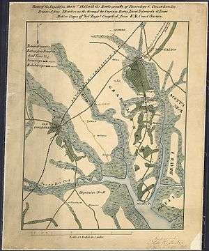
The Second Battle of Pocotaligo, or Battle of Pocotaligo Bridge, or Battle of Yemassee, often referred to as simply the Battle of Pocotaligo, was a battle in the American Civil War on October 22, 1862 near Yemassee, South Carolina.[6][7] The Union objective was to sever the Charleston and Savannah Railroad and thus isolate Charleston, South Carolina.
Battle
On October 21, 1862, a Union force of 4200 men, under the command of Brigadier General John M. Brannan, boarded transport ships and left Hilton Head, South Carolina. Brannan's orders were "to destroy the railroad and railroad bridges on the Charleston and Savannah line."[3] Under protection of a Naval Squadron, they sailed up the Broad River, disembarking the next morning at Mackey Point (between the Coosawhatchie and Pocotaligo Rivers), less than ten miles distant from the railroad.[1] The 47th and 55th Pennsylvania Infantry Regiments, under the command of Colonel Tilghman H. Good, began the march toward Pocotaligo.[8] A smaller detachment of 300 men – two companies of engineers and the 48th New York regiment – moved up the Coosawhatchie River with orders to attack the bridge at Coosawhatchie and then turn towards Pocotaligo tearing up the rails as they went.[1][3]
Colonel William S. Walker, the Confederate commander responsible for defending the railroad, called for reinforcement from Charleston and Savannah, and deployed his forces to meet the two Union advances, sending 200 of his men to guard the bridge, while the Beaufort Volunteer Artillery (CS), supported by two companies of cavalry and some sharpshooters, were dispatched to meet the main Union advance on the Mackey Point road. Brannan's Division encountered the Rebels near the abandoned Caston's Plantation when the Confederate artillery opened fire with their two howitzers. The Confederates retreated when the Union artillery responded.[1][3]
With Brannan in pursuit, Walker slowly withdrew, making a rolling defense and eventually falling back to the defensive works at Pocotaligo. The Union advance stalled when they encountered the Confederates on the opposite side of a muddy marsh. Brigadier General Alfred Terry, in command of the Second Brigade, ordered the nearly 100 Sharps rifleman of the 7th Connecticut Infantry forward to the edge of the woods where the Union forces had taken cover. The rapid fire of the repeating rifles quickly suppressed the fire from the Confederate battery and associated infantry across the marsh, and they were soon ordered to cease firing to preserve ammunition.[9] The opposing forces blazed away with musket and cannon fire at intervals for more than two hours, until the arrival of Confederate reinforcements.[3][8] By then it was late in the day, and the Union troops were running low on ammunition.
Aftermath
As night fell, Brannan, realizing that the railroad bridge was out of reach, ordered retreat up the Mackay's Point road to the safety of his flotilla, the 47th Pennsylvania Infantry forming the rearguard, with the Rutledge Mounted Rifles and Kirk's Partisan Rangers in pursuit.[3][10] Brannan's troops reembarked at Mackay's Point the next morning and returned to Hilton Head.[9]
References
- 1 2 3 4 5 Smith, Steven; Christopher Ohm Clement; Stephen R. Wise (June 2003). "GPS, GIS and the Civil War Battlefield Landscape: A South Carolina Low Country Example". Historical Archaeology. 37 (3): 14–30. ISSN 0440-9213. Retrieved 11 November 2012.
- ↑ "The War News". American Volunteer. 6 November 1862. Retrieved 11 November 2012.
- 1 2 3 4 5 6 7 "Battle of Pocotaligo". Colonel Charles Jones Colcock Camp #2100, Sons of Confederate Veterans. Retrieved 11 November 2012.
- 1 2 Evans, Clement A., ed. Confederate Military History: A Library of Confederate States History. Volume: 5. Capers, Ellison; South Carolina. Atlanta: Confederate Publishing Company, 1899. OCLC 833588. Retrieved January 20, 2011. p. 106.
- 1 2 Emerson, W. Eric. Sons of Privilege: The Charleston Light Dragoons in the Civil War. Columbia: University of South Carolina Press, 2005. ISBN 978-1-57003-592-0. Retrieved October 23, 2012. p. 50.
- ↑ New Hampshire. Adjutant-General's Office (1865). Report of the Adjutant-General of the State of New Hampshire. John B. Clarke, State Printer. p. 793. Retrieved 19 September 2013.
- ↑ The Land We Love. Jas. P. Irwin & D.H. Hill. 1868. p. 455. Retrieved 19 September 2013.
- 1 2 Dewig, Rob (27 January 1998). "Two Jasper County battles helped prolong Confederacy". Savannah Morning News. Retrieved 13 November 2012.
- 1 2 Stephen W. Walkley, Jr (1905). History of the Seventh Connecticut volunteer infantry, Hawley's brigade, Terry's division, Tenth army corps, 1861-1865. Hartford. p. 62. Retrieved 10 June 2016.
- ↑ Emerson, 2005, p. 47

