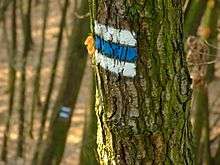
Czech Hiking Markers System
Czech Hiking Markers Standard is an international hiking markers system for tourist trails. This way of trail blazing is used throughout most of Central Europe, probably in the highest number of countries of all standards known. The system has been perfected by Czech Hiking Club since 1889.[1]
In the Czech Republic only, there has been 39.816 km hiking trails marked in 2008 plus 31.104 km cycling trails plus 387 km skying trails and 1300 km horse riding trail, with the entire territory of the country covered with marked trails and detailed maps published and easily available. While in 1938 it was the longest[2] system on the world, it now forms the densest[2] network of marked trails anywhere.
Czech Markers Standard
These European countries use three bars - usually one color in between two white bars,[3] with different meanings attached to different colours, with red being the most difficult or summit trails,[4] blue for difficult trails and yellow and green for easy or interconnecting trails.

Basic trail markers are rectangular, 10x10 cm in size.
Any change of direction is marked with arrows of the same color and similar design.
.jpg)
The system is usually connected to maps, showing the colored lines of the trails. Nevertheless, the maps are not necessary for a good functioning of the systems, as shown in some poorer countries.
Czech Markers around the World
The relative ease of use and low cost, the system has been recently spreading around the world.. Originally used in the Czech Republic, the system spread to neighbouring Central Europe (the Czech Republic, Slovakia, Poland), the Balkans (Croatia, Bulgaria, Bosnia & Herzegovina), recently also to Eastern Europe (Ukraine and Georgia) and other parts of the world:
- The Czech Republic with the country fully covered with marked trails and detailed maps and the densest trail network on the world
- Slovakia[5] with the country fully covered with marked trails and detailed maps
- Austria's standard is almost identical, however with red-white-red combination of colors.[6]
- Bosnia - Maglić Mountain
- Croatia[7] especially on the island of Krk
- Poland identical but with 5 colors markers (one color - black - added to the 4 Czech colors markers), trails marked especially alongside Czech and Slovak borders
- Ukraine[8] especially in Subcarpathian Ukraine[9] and Crimea[10] with some 700 km of trails marked in 2011 in Subcarpathia and continuing efforts by Czech, Ukraininan and Polish volunteers to mark additional routes.
- Bulgaria
- Georgia - some Caucasus trails marked by Czech volunteers
The system has started to be used also out of Europe, even so far away as in
References
- ↑ Farley, David (6 July 2008). "Hiking in the Czech Republic". The New York Times. Retrieved 25 November 2016.
- 1 2 "Czech Trail Marking System the Best in the World".
- ↑ "KČT - Czech Tourist Klub (KČT)". www.kct.cz.
- ↑ "Hiking in the Czech Republic". Retrieved 25 November 2016.
- ↑ http://www.slovakation.com/system-of-hiking-trails-in-slovakia-belongs-to-the-best-in-the-world/ Hiking Markers in Slovakia
- ↑ http://archive.is/qLl2H Austrian Mountain Trail Marker
- ↑ http://www.trail-busters.cz/trail.php?x=496 Hiking Markers in Croatia on one of the lower pictures
- ↑ http://www.treking.cz/archiv/znaceni-na-zakarpati.htm Hiking Markers in Ukraine
- ↑ "České značky přinášejí naději".
- ↑ http://www.mzv.cz/jnp/cz/udalosti_a_media/archiv_zprav/rok_2011/x2011_06_10_ceske_turisticke_znacky_na_krymu.html
- ↑ http://cestovani.idnes.cz/ceske-turisticke-znacky-brazilie-dqv-/kolem-sveta.aspx?c=A161021_2281003_kolem-sveta_hig Hiking Markers in Brasil
