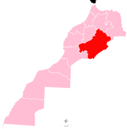
Drâa-Tafilalet
| Drâa-Tafilalet درعة - تافيلالت | |
|---|---|
| Region | |
 Location in Morocco | |
| Coordinates: 31°19′N 5°20′W / 31.32°N 5.33°WCoordinates: 31°19′N 5°20′W / 31.32°N 5.33°W | |
| Country |
|
| Created | September 2015 |
| Capital | Errachidia |
| Government | |
| • President | Lahbib Choubani |
| Area[1] | |
| • Total | 86,142[2] km2 (53,828 sq mi) |
| Population (1 September 2014)[1] | |
| • Total | 1,635,008 |
| • Density | 12/km2 (30/sq mi) |
| Time zone | WET (UTC+0) |
| • Summer (DST) | WEST (UTC+1) |
Drâa-Tafilalet (Arabic: درعة - تافيلالت) is one of the twelve regions of Morocco. It covers an area of 86,142 km² and had a population of 1,635,008 as of the 2014 Moroccan census.[1] The capital of the region is Errachidia.[3]
Geography
Drâa-Tafilalet is situated in the Atlas Mountains of Morocco. Its main watersheds are that of the Draa River in the west and the Ziz River, which irrigates the Tafilalt oasis, in the east. Drâa-Tafilalet borders five other Moroccan regions: Souss-Massa to the southwest, Marrakech-Safi to the west, Béni Mellal-Khénifra to the northwest, Fès-Meknès to the north, and Oriental to the northeast. It also borders two of Algeria's provinces, Tindouf in the south and Béchar in the southeast.
History
Drâa-Tafilalet was formed in September 2015 by integrating the provinces of Errachidia and Midelt in Meknès-Tafilalet region with three provinces of the Souss-Massa-Drâa region.[3]
Government
Lahbib Choubani of the Justice and Development Party was elected as the regional council's first president on 14 September 2015.[4]
Subdivisions
Drâa-Tafilalet comprises five provinces:[3]
Economy
Agriculture and pastoralism have traditionally been major economic activities in the region, but they have been adversely impacted in recent years by increasing desertification.[5][6] There is a film-making industry concentrated in the Ouarzazate area.[7] The fortified towns in the area, such as the World Heritage Site Aït Benhaddou, are popular tourist attractions. Traditional arts and crafts such as the pottery of Tamegroute and the rugs of Taznakht are also significant to the local economy.[8]
Infrastructure
The largest towns in the region, Errachidia and Ouarzazate, are linked together by National Route 10. The Draa valley is served by National Route 9 which also links Ouarzazate with Marrakesh to the northwest. National Route 13 runs along the Ziz valley and links Errachidia with Meknes to the north. Ouarzazate has the busiest airport in the region; the airports at Errachidia and Zagora also have commercial service.
References
- 1 2 3 Law, Gwillim. "Regions of Morocco". Statoids. Retrieved 11 December 2015.
- ↑ Drâa-Tafilalet – Statistics
- 1 2 3 "Décret fixant le nom des régions" (pdf). Portail National des Collectivités Territoriales (in French). 20 February 2015. Retrieved 11 December 2015.
- ↑ "Ministère de l'Intérieur : l'élection des présidents des Conseils des régions s'est déroulée dans de bonnes conditions et dans un climat de transparence" [Ministry of the Interior: the regional council presidential elections took place under good conditions and in an air of transparency] (Press release) (in French). Maghreb Arabe Press. 14 September 2015. Retrieved 12 December 2015.
- ↑ "L'Agriculture". Souss-Massa Region. Retrieved 11 December 2015.
- ↑ Alali, A.; Benmohammadi, A. (2013). "L'ensablement dans la plaine de Tafilalet (Sud-est du Maroc)". LARHYSS (16): 53–75. Retrieved 12 December 2015.
- ↑ "OUARZAZATE, CAPITALE MONDIALE DU CINÉMA DU DÉSERT". Souss-Massa Region. Retrieved 12 December 2015.
- ↑ "L'ARTISANAT". Souss-Massa Region. Retrieved 11 December 2015.