Finsevatnet
| Finsevatnet | |
|---|---|
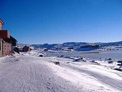
 View of the lake (right side of picture) | |
| Location | Ulvik, Hordaland |
| Coordinates | 60°35′33″N 7°28′47″E / 60.5925°N 7.4798°E / 60.5925; 7.4798Coordinates: 60°35′33″N 7°28′47″E / 60.5925°N 7.4798°E / 60.5925; 7.4798 |
| Basin countries | Norway |
| Max. length | 4 kilometres (2.5 mi) |
| Max. width | 1.2 kilometres (0.75 mi) |
| Surface area | 3.14 km2 (1.21 sq mi) |
| Shore length1 | 11.71 kilometres (7.28 mi) |
| Surface elevation | 1,214 metres (3,983 ft) |
| Settlements | Finse |
| References | NVE |
| 1 Shore length is not a well-defined measure. | |
Finsevatnet is a lake in the municipality of Ulvik in Hordaland county, Norway. The 3.14-square-kilometre (1.21 sq mi) lake lies just south of the village of Finse where the Finse Station on the Bergensbanen railway line is located. The Finse Tunnel is located just north of the lake. The southeast side of the lake has a dam which regulates the depth of the lake for the purposes of hydro-electric power generation.[1][2]
See also
References
- ↑ Store norske leksikon. "Finsevatn" (in Norwegian). Retrieved 2014-05-25.
- ↑ "Finsevatnet" (in Norwegian). yr.no. Retrieved 2014-05-25.
This article is issued from Wikipedia - version of the 2/3/2015. The text is available under the Creative Commons Attribution/Share Alike but additional terms may apply for the media files.