Fongshan Junior High School Station
Fongshan Junior High School 鳳山國中 | |
|---|---|
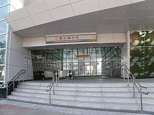 Fongshan Junior High School Station Exit 3 | |
| Location |
Fongshan, Kaohsiung Taiwan |
| Operated by | |
| Line(s) |
|
| Platforms | 1 island platform |
| Connections | Bus stop |
| Construction | |
| Structure type | Underground |
| Disabled access | Yes |
| History | |
| Opened | September 14, 2008 |
| Traffic | |
| Passengers | 2,670 daily (Jan. 2011)[1] |
| Fongshan Junior High School Station | |||||||||||||
| Traditional Chinese | 鳳山國中車站 | ||||||||||||
|---|---|---|---|---|---|---|---|---|---|---|---|---|---|
| Simplified Chinese | 凤山国中车站 | ||||||||||||
| |||||||||||||
The Kaohsiung MRT Fongshan Junior High School Station is station on the Orange Line in Fongshan District, Kaohsiung, Taiwan.
Station overview
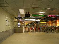
Basement Concourse of Fongshan Junior High School Station
The station is a two-level, underground station with an island platform and three exits.[2] The station is 256 meters long and is located at the intersection of Jhongshan E. Rd. and Ren-ai Rd.[3]
Station layout
| G | Street Level | Entrance/Exit |
| B1 | Concourse | Lobby, information desk, automatic ticket machines, one-way faregates, Restrooms (Near Exit 1) |
| B2 | Platform 1 | ← KMRT Orange Line toward Sizihwan (Dadong) |
| Island platform, doors will open on the left | ||
| Platform 2 | → KMRT Orange Line toward Daliao (Terminus) → | |
Exits
- Exit 1: Fongshan Junior High School

- Exit 2: Fongshan Post Office Ren-ai Market
- Exit 3: Chengde St., Shengli Rd., Jhongjheng Elementary School
Around the station
- Fongshan Junior High School
- Chunghwa Post Fongshan Post Office
- Whampoa Military Academy
- Former Japanese Navy Fongshan Communication Center
Nearby stations
| Preceding station | Kaohsiung MRT | Following station | ||
|---|---|---|---|---|
toward Sizihwan | Orange Line | Terminus |
References
| Wikimedia Commons has media related to Fongshan Junior High School Station. |
- ↑ "統計資訊 > 統計月報". Transportation Bureau, Kaohsiung City Government. Retrieved 2011-02-15.
- ↑ "鳳山國中站". 高雄捷運公司. Retrieved 2010-07-05.
- ↑ "鳳山國中站週邊地圖". 高雄捷運公司. Retrieved 2010-07-05.
Coordinates: 22°37′30″N 120°22′21″E / 22.62500°N 120.37250°E
This article is issued from Wikipedia - version of the 10/19/2016. The text is available under the Creative Commons Attribution/Share Alike but additional terms may apply for the media files.