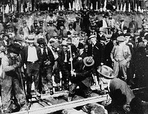
Fort Fraser, British Columbia

Fort Fraser is an unincorporated community of about 500 people, situated near the base of Fraser Mountain, close to the village municipality of Fraser Lake and the Nechako River. It can be found near the geographical centre of British Columbia, Canada, 44 km (27 mi) west of Vanderhoof on the Yellowhead Highway. Originally established in 1806 as a North West Company fur trading post by the explorer Simon Fraser, it is one of present-day British Columbia's oldest permanent European-founded settlements. The area around the community is also recorded as the site of the first land in British Columbia cultivated by non-First Nations people.
The original site of the fort is 4 km (2 mi) to the west, in Beaumont Provincial Park. In 1911, the fort was relocated to nearby Nadleh Village, and later closed in 1915. The present community is located at the site of the last spike of the Grand Trunk Pacific Railway, driven on April 7, 1914. Today, Fort Fraser is an active community sustained by both forestry and tourism.
Via Rail's Jasper – Prince Rupert train calls at the Fort Fraser railway station.
The Fort Fraser Fall Fair is one of the oldest agricultural fairs in BC. The event has run annually since 1928, on the Labour Day weekend in September.

Local facilities include:
- 3 churches - United Church of Canada, Apostolic Lutheran Church (est. 1928 by St. Mary's Anglican Church), and Church of the Nazarene
- Petro-Canada gas station/grocery store/restaurant
- Last Spike Pub, Cold Beer & Wine store
- Durham Garage, Towing Service, Automotive repairs, Tire sales
- Community hall
- Post-office
- Motel
- Laundromat
- Visitor information centre
Climate
| Climate data for Fort Fraser | |||||||||||||
|---|---|---|---|---|---|---|---|---|---|---|---|---|---|
| Month | Jan | Feb | Mar | Apr | May | Jun | Jul | Aug | Sep | Oct | Nov | Dec | Year |
| Record high °C (°F) | 12.0 (53.6) |
14.5 (58.1) |
19.0 (66.2) |
28.9 (84) |
35.5 (95.9) |
32.0 (89.6) |
33.5 (92.3) |
35.5 (95.9) |
34.0 (93.2) |
26.0 (78.8) |
17.0 (62.6) |
14.0 (57.2) |
35.5 (95.9) |
| Average high °C (°F) | −4.1 (24.6) |
−0.3 (31.5) |
6.1 (43) |
11.5 (52.7) |
16.9 (62.4) |
19.9 (67.8) |
22.4 (72.3) |
22.5 (72.5) |
17.4 (63.3) |
10.0 (50) |
0.3 (32.5) |
−4.5 (23.9) |
9.8 (49.6) |
| Daily mean °C (°F) | −9.0 (15.8) |
−6.2 (20.8) |
−0.7 (30.7) |
3.9 (39) |
8.9 (48) |
12.2 (54) |
14.5 (58.1) |
14.2 (57.6) |
9.8 (49.6) |
4.0 (39.2) |
−4.0 (24.8) |
−9.1 (15.6) |
3.2 (37.8) |
| Average low °C (°F) | −13.9 (7) |
−12.1 (10.2) |
−7.4 (18.7) |
−3.6 (25.5) |
0.9 (33.6) |
4.5 (40.1) |
6.5 (43.7) |
5.8 (42.4) |
2.1 (35.8) |
−2.0 (28.4) |
−8.3 (17.1) |
−13.6 (7.5) |
−3.4 (25.9) |
| Record low °C (°F) | −45.5 (−49.9) |
−43.0 (−45.4) |
−38.3 (−36.9) |
−16.0 (3.2) |
−7.0 (19.4) |
−3.0 (26.6) |
−2.5 (27.5) |
−5.0 (23) |
−9.0 (15.8) |
−29.0 (−20.2) |
−44.5 (−48.1) |
−45.5 (−49.9) |
−45.5 (−49.9) |
| Average precipitation mm (inches) | 46.5 (1.831) |
30.0 (1.181) |
20.9 (0.823) |
26.8 (1.055) |
42.2 (1.661) |
66.7 (2.626) |
62.3 (2.453) |
43.4 (1.709) |
44.8 (1.764) |
46.0 (1.811) |
51.7 (2.035) |
44.5 (1.752) |
525.8 (20.701) |
| Average rainfall mm (inches) | 5.3 (0.209) |
5.9 (0.232) |
5.2 (0.205) |
19.3 (0.76) |
41.3 (1.626) |
66.7 (2.626) |
62.3 (2.453) |
43.4 (1.709) |
44.3 (1.744) |
36.4 (1.433) |
14.2 (0.559) |
2.7 (0.106) |
346.8 (13.654) |
| Average snowfall cm (inches) | 41.2 (16.22) |
24.1 (9.49) |
15.8 (6.22) |
7.5 (2.95) |
0.9 (0.35) |
0.0 (0) |
0.0 (0) |
0.0 (0) |
0.5 (0.2) |
9.6 (3.78) |
37.5 (14.76) |
41.8 (16.46) |
178.9 (70.43) |
| Average precipitation days (≥ 0.2 mm) | 11.9 | 9.3 | 7.5 | 10.4 | 13.5 | 14.5 | 13.5 | 12.2 | 12.2 | 13.5 | 14.0 | 10.6 | 143.0 |
| Average rainy days (≥ 0.2 mm) | 2.2 | 2.6 | 3.0 | 7.7 | 13.2 | 14.5 | 13.5 | 12.2 | 12.1 | 11.9 | 4.7 | 1.4 | 98.9 |
| Average snowy days (≥ 0.2 cm) | 10.3 | 7.4 | 5.3 | 3.8 | 0.4 | 0.0 | 0.0 | 0.0 | 0.2 | 2.9 | 11.1 | 10.1 | 51.5 |
| Source: [1] | |||||||||||||
Directions
Nearby communities of Fort Fraser include:
Fraser Lake - 21 km (13 mi) Vanderhoof - 38 km (24 mi) Fort St. James - 84 km (52 mi) Burns Lake - 90 km (56 mi) Prince George - 134 km (83 mi) Topley - 141 km (88 mi) Smithers - 234 km (145 mi)
Terrace - 437 km (272 mi)
Prince Rupert - 581 km (361 mi)
See also
References
- ↑ "Calculation Information for 1981 to 2010 Canadian Normals Data". Environment Canada. Retrieved July 9, 2013.
External links
Coordinates: 54°03′51″N 124°32′54″W / 54.06424°N 124.54823°W