Grade I listed buildings in Staffordshire

Staffordshire shown within England

There are over 9000 Grade I listed buildings in England. This page is a list of these buildings in the county of Staffordshire, by district.

City of Stoke-on-Trent

Name Location Type Completed [note 1]Date designated Grid ref.[note 2]
Geo-coordinates
Entry number [note 3]Image
Trentham Mausoleum Trentham Mausoleum c.1808 19 April 1972 SJ8680441062
52°58′00″N 2°11′53″W / 52.966754°N 2.197922°W / 52.966754; -2.197922 (Trentham Mausoleum)
1210451

East Staffordshire

Name Location Type Completed [note 1]Date designated Grid ref.[note 2]
Geo-coordinates
Entry number [note 3]Image
Blithfield Hall Blithfield Park, Blithfield Country House 16th century 10 January 1953 SK0449823934
52°48′47″N 1°56′05″W / 52.812932°N 1.934708°W / 52.812932; -1.934708 (Blithfield Hall)
1190006
Church of St Leonard Blithfield Parish Church c. 1300 12 January 1966 SK0441623991
52°48′48″N 1°56′09″W / 52.813445°N 1.935923°W / 52.813445; -1.935923 (Church of St Leonard)
1294024
Church of St Modwen Burton upon Trent Parish Church 1719-26 24 March 1950 SK2509922715
52°48′05″N 1°37′45″W / 52.801413°N 1.629161°W / 52.801413; -1.629161 (Church of St Modwen)
1214046
Croxden Abbey Croxden Abbey 1179–1280 12 January 1966 SK0658339695
52°57′17″N 1°54′12″W / 52.954592°N 1.903461°W / 52.954592; -1.903461 (Croxden Abbey)
1230576
Church of the Holy Angels Hoar Cross Church 1872-78 12 March 1964 SK1248723046
52°48′17″N 1°48′58″W / 52.804825°N 1.816214°W / 52.804825; -1.816214 (Church of the Holy Angels)
1038507
Church of St Chad Burton upon Trent Church 1903 22 June 1979 SK2461424458
52°49′02″N 1°38′10″W / 52.817104°N 1.636224°W / 52.817104; -1.636224 (Church of St Chad)
1038702
Church of St John Baptist Mayfield Parish Church Late 12th century 12 January 1966 SK1542844752
53°00′00″N 1°46′18″W / 52.99987°N 1.771566°W / 52.99987; -1.771566 (Church of St John Baptist)
1230760
Wootton Lodge Wootton Park, Ramshorn Country House c. 1600 10 January 1953 SK0956343800
52°59′29″N 1°51′32″W / 52.991448°N 1.858984°W / 52.991448; -1.858984 (Wootton Lodge)
1278308
Church of St Mary Rolleston on Dove Parish Church 12th century 12 March 1964 SK2356427718
52°50′47″N 1°39′06″W / 52.846455°N 1.65157°W / 52.846455; -1.65157 (Church of St Mary)
1374442
Church of St Mary Tutbury Parish Church 1160-70 12 March 1964 SK2111829107
52°51′33″N 1°41′16″W / 52.859042°N 1.687797°W / 52.859042; -1.687797 (Church of St Mary)
1038524
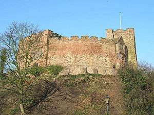
Tutbury Castle Tutbury Castle 12th century 26 April 1984 SK2092429117
52°51′33″N 1°41′26″W / 52.85914°N 1.690678°W / 52.85914; -1.690678 (Tutbury Castle)
1374431

Lichfield District

Name Location Type Completed [note 1]Date designated Grid ref.[note 2]
Geo-coordinates
Entry number [note 3]Image
Church of All Saints Alrewas Parish Church 13th century 20 November 1986 SK1676915267
52°44′05″N 1°45′11″W / 52.734781°N 1.753093°W / 52.734781; -1.753093 (Church of All Saints)
1038926
Church of St Andrew Clifton Campville Parish Church Early 13th century 27 February 1964 SK2529010784
52°41′39″N 1°37′38″W / 52.694152°N 1.627244°W / 52.694152; -1.627244 (Church of St Andrew)
1038808
Church of St Michael and All Angels Hamstall Ridware Parish Church 12th century 27 February 1964 SK1056519346
52°46′18″N 1°50′41″W / 52.771605°N 1.844842°W / 52.771605; -1.844842 (Church of St Michael and All Angels)
1190715
Church of All Saints Kings Bromley Parish Church 16th century 27 February 1964 SK1220817025
52°45′03″N 1°49′14″W / 52.750706°N 1.820575°W / 52.750706; -1.820575 (Church of All Saints)
1277769
Cathedral Church of the Blessed Virgin Mary and St Chad Lichfield Cathedral 19th century 5 February 1952 SK1156309742
52°41′07″N 1°49′49″W / 52.685249°N 1.830385°W / 52.685249; -1.830385 (Cathedral Church of the Blessed Virgin Mary and St Chad)
1298431
Erasmus Darwin House Lichfield House c. 1758 5 February 1952 SK1141209709
52°41′06″N 1°49′57″W / 52.684956°N 1.83262°W / 52.684956; -1.83262 (Erasmus Darwin House)
1187355
Hospital of St John Baptist without the Barrs Lichfield Almshouse and chapel 19th century 5 February 1952 SK1175409131
52°40′47″N 1°49′39″W / 52.679753°N 1.827581°W / 52.679753; -1.827581 (Hospital of St John Baptist without the Barrs)
1218231
Samuel Johnson Birthplace Museum Lichfield Timber Framed House c. 1707 5 February 1952 SK1173009542
52°41′00″N 1°49′41″W / 52.683448°N 1.827921°W / 52.683448; -1.827921 (Samuel Johnson Birthplace Museum)
1292492
Master's House to rear of Hospital of St John Baptist without the Barrs Lichfield Teachers House cira 1495 5 February 1952 SK1172909178
52°40′49″N 1°49′41″W / 52.680176°N 1.827949°W / 52.680176; -1.827949 (Master's House to rear of Hospital of St John Baptist without the Barrs)
1298403
St Chad's Cathedral School and Chapel Lichfield Bishops Palace 1687-8 5 February 1952 SK1156009830
52°41′10″N 1°49′50″W / 52.68604°N 1.830426°W / 52.68604; -1.830426 (St Chad's Cathedral School and Chapel)
1218871
Church of St Nicholas Mavesyn Ridware Parish Church Template:Sot 27 February 1964 SK0816216871
52°44′58″N 1°52′50″W / 52.749397°N 1.880521°W / 52.749397; -1.880521 (Church of St Nicholas)
1249035
Gatehouse at Old Hall Mavesyn Ridware Gatehouse 14th century 27 February 1964 SK0812916781
52°44′55″N 1°52′52″W / 52.748589°N 1.881012°W / 52.748589; -1.881012 (Gatehouse at Old Hall)
1249047

Newcastle-under-Lyme

Name Location Type Completed [note 1]Date designated Grid ref.[note 2]
Geo-coordinates
Entry number [note 3]Image
Church of St Margaret Betley Parish Church 17th century 17 November 1966 SJ7556348459
53°01′58″N 2°21′57″W / 53.032849°N 2.365848°W / 53.032849; -2.365848 (Church of St Margaret)
1038581
Church of All Saints Madeley Parish Church 12th century 17 November 1966 SJ7730144377
52°59′46″N 2°20′23″W / 52.996233°N 2.339644°W / 52.996233; -2.339644 (Church of All Saints)
1206195
Whitmore Hall Whitmore House Late 19th century 2 December 1952 SJ8109041266
52°58′06″N 2°16′59″W / 52.968415°N 2.283009°W / 52.968415; -2.283009 (Whitmore Hall)
1206579

South Staffordshire

Name Location Type Completed [note 1]Date designated Grid ref.[note 2]
Geo-coordinates
Entry number [note 3]Image
Weston Park and service wings to north and east Weston Park, Weston-under-Lizard Country House 17th century 16 May 1953 SJ8064010629
52°41′35″N 2°17′16″W / 52.692994°N 2.287881°W / 52.692994; -2.287881 (Weston Park and service wings to north and east)
1039264
Bridge at Weston Park Weston Park, Weston-under-Lizard Bridge 1760s 16 May 1953 SJ8131810383
52°41′27″N 2°16′40″W / 52.690806°N 2.277836°W / 52.690806; -2.277836 (Bridge at Weston Park)
1039268
Temple of Diana at Weston Park Weston Park, Weston-under-Lizard Garden House c. 1760 16 May 1953 SJ8104310441
52°41′29″N 2°16′55″W / 52.691318°N 2.281907°W / 52.691318; -2.281907 (Temple of Diana at Weston Park)
1188135
Church of St Andrew, Weston-under-Lizard Weston-under-Lizard Church c. 1701 19 March 1962 SJ8061210649
52°41′35″N 2°17′18″W / 52.693173°N 2.288296°W / 52.693173; -2.288296 (Church of St Andrew, Weston-under-Lizard)
1294950
St Mary's Church, Blymhill Blymhill Tower Early 15th century 19 March 1962 SJ8085112234
52°42′27″N 2°17′05″W / 52.70743°N 2.284853°W / 52.70743; -2.284853 (St Mary's Church, Blymhill)
1039272
Chillington Hall Chillington Park, Brewood Country House 1724 16 May 1953 SJ8636606776
52°39′31″N 2°12′11″W / 52.658533°N 2.203001°W / 52.658533; -2.203001 (Chillington Hall)
1060191
Church of St Mary and St Chad Brewood Parish Church 13th century 19 March 1962 SJ8834908664
52°40′32″N 2°10′26″W / 52.675552°N 2.173752°W / 52.675552; -2.173752 (Church of St Mary and St Chad)
1060197
The Grecian Temple at Chillington Hall Chillington Park, Brewood Garden Temple Late 18th century 16 May 1953 SJ8540205371
52°38′45″N 2°13′02″W / 52.645877°N 2.21719°W / 52.645877; -2.21719 (The Grecian Temple at Chillington Hall)
1295261
Hilton Hall Hilton Park, Hilton Country House 1720-30 16 May 1953 SJ9521005184
52°38′40″N 2°04′20″W / 52.644373°N 2.072228°W / 52.644373; -2.072228 (Hilton Hall)
1039174
The Conservatory at Hilton Hall Hilton Park, Hilton Conservatory Early 19th century 16 May 1953 SJ9513005274
52°38′43″N 2°04′24″W / 52.645181°N 2.073411°W / 52.645181; -2.073411 (The Conservatory at Hilton Hall)
1039176
Church of St Peter Kinver Church 14th century 27 June 1963 SO8461483049
52°26′43″N 2°13′40″W / 52.445185°N 2.227794°W / 52.445185; -2.227794 (Church of St Peter)
1230950
Church of All Saints Lapley Parish Church 12th century 19 March 1962 SJ8724012934
52°42′50″N 2°11′25″W / 52.713912°N 2.190321°W / 52.713912; -2.190321 (Church of All Saints)
1374057
Patshull Hall and north west and north east wings to north forecourt Patshull Park, Pattingham Country House 18th century 16 June 1953 SJ8024600931
52°36′21″N 2°17′35″W / 52.605799°N 2.293126°W / 52.605799; -2.293126 (Patshull Hall and north west and north east wings to north forecourt)
1039327
Triumphal entry to forecourt of Patshull Hall and flanking screen walls Patshull Park, Pattingham Gatehouse c. 1750 16 June 1953 SJ8022600953
52°36′22″N 2°17′36″W / 52.605996°N 2.293423°W / 52.605996; -2.293423 (Triumphal entry to forecourt of Patshull Hall and flanking screen walls)
1294872
Church of St Michael and All Angels Penkridge Collegiate Church 13th century 19 March 1962 SJ9214414160
52°43′30″N 2°07′04″W / 52.725028°N 2.117758°W / 52.725028; -2.117758 (Church of St Michael and All Angels)
1039195

Stafford Borough

Name Location Type Completed [note 1]Date designated Grid ref.[note 2]
Geo-coordinates
Entry number [note 3]Image
Barlaston Hall Barlaston Country House 1756-8 10 January 1953 SJ8944239114
52°56′57″N 2°09′31″W / 52.949302°N 2.158581°W / 52.949302; -2.158581 (Barlaston Hall)
1374172
Church of St Mary and All Saints Bradley Church Late 13th/early 14th century 15 January 1968 SJ8795618050
52°45′36″N 2°10′48″W / 52.759919°N 2.179911°W / 52.759919; -2.179911 (Church of St Mary and All Saints)
1319799
Church of All Saints Chebsey Church 13th century 24 January 1967 SJ8596828586
52°51′16″N 2°12′35″W / 52.854583°N 2.209826°W / 52.854583; -2.209826 (Church of All Saints)
1374173
Shugborough Hall Colwich Country House c. 1695 17 March 1953 SJ9922422493
52°48′00″N 2°00′47″W / 52.799995°N 2.012951°W / 52.799995; -2.012951 (Shugborough Hall)
1079637
Chinese House at Shugborough Hall Colwich Garden Building c. 1747 17 March 1953 SJ9924922718
52°48′07″N 2°00′45″W / 52.802018°N 2.01258°W / 52.802018; -2.01258 (Chinese House at Shugborough Hall)
1358640
Dark Lantern at Shugborough Hall Colwich Garden Feature c. 1765 17 March 1953 SJ9848321938
52°47′42″N 2°01′26″W / 52.795004°N 2.023938°W / 52.795004; -2.023938 (Dark Lantern at Shugborough Hall)
1065771
Doric Temple at Shugborough Hall to north of the house Colwich Garden Temple c. 1760 15 January 1968 SJ9925322579
52°48′03″N 2°00′45″W / 52.800768°N 2.012521°W / 52.800768; -2.012521 (Doric Temple at Shugborough Hall to north of the house)
1079641
Garden Bridge at Shugborough Hall Colwich Ornamental Bridge Late 18th century 17 March 1953 SJ9926122705
52°48′07″N 2°00′45″W / 52.801901°N 2.012402°W / 52.801901; -2.012402 (Garden Bridge at Shugborough Hall)
1079642
Triumphal Arch at Shugborough Hall Colwich Triumphal Arch c. 1765 17 March 1953 SJ9866021589
52°47′31″N 2°01′17″W / 52.791868°N 2.021312°W / 52.791868; -2.021312 (Triumphal Arch at Shugborough Hall)
1039140
Essex Bridge Colwich Bridge 16th century 10 January 1972 SJ9951722564
52°48′02″N 2°00′31″W / 52.800634°N 2.008605°W / 52.800634; -2.008605 (Essex Bridge)
1079635
Broughton Hall Eccleshall Country House 1637 10 January 1953 SJ7667333886
52°54′07″N 2°20′54″W / 52.901901°N 2.348241°W / 52.901901; -2.348241 (Broughton Hall)
1189282
Church of St Peter Broughton, Eccleshall Church 17th century 24 January 1967 SJ7661233717
52°54′01″N 2°20′57″W / 52.900379°N 2.349136°W / 52.900379; -2.349136 (Church of St Peter)
1039045
Church of the Holy Trinity Eccleshall Church 13th century 24 January 1967 SJ8275829179
52°51′35″N 2°15′27″W / 52.85982°N 2.257527°W / 52.85982; -2.257527 (Church of the Holy Trinity)
1180335
Church of St Lawrence Gnosall Church 13th century 15 January 1968 SJ8301520889
52°47′07″N 2°15′12″W / 52.785306°N 2.253276°W / 52.785306; -2.253276 (Church of St Lawrence)
1242645
St Mary's Church High Offley Parish Church 12th century 15 January 1968 SJ7835126161
52°49′57″N 2°19′22″W / 52.83253°N 2.322779°W / 52.83253; -2.322779 (St Mary's Church)
1242831
Church of St Mary Ingestre Church 1676 15 January 1968 SJ9766824692
52°49′11″N 2°02′10″W / 52.819758°N 2.036046°W / 52.819758; -2.036046 (Church of St Mary)
1259814
Church of St Peter Norbury Church 18th century 15 January 1968 SJ7863323473
52°48′30″N 2°19′06″W / 52.808378°N 2.318417°W / 52.808378; -2.318417 (Church of St Peter)
1242976
Church of All Saints Sandon Church Late 12th or early 13th century 24 January 1967 SJ9540929489
52°51′46″N 2°04′11″W / 52.862865°N 2.069635°W / 52.862865; -2.069635 (Church of All Saints)
1294163
Church of All Saints Standon Church 14th century 24 January 1967 SJ8194934975
52°54′43″N 2°16′12″W / 52.911894°N 2.269866°W / 52.911894; -2.269866 (Church of All Saints)
1039004
Church of St Mary Swynnerton Church 13th century 24 January 1967 SJ8522935503
52°55′00″N 2°13′16″W / 52.916742°N 2.221117°W / 52.916742; -2.221117 (Church of St Mary)
1374205
Swynnerton Hall Swynnerton House c. 1725 10 January 1953 SJ8521235444
52°54′58″N 2°13′17″W / 52.916211°N 2.221367°W / 52.916211; -2.221367 (Swynnerton Hall)
1038991
Tixall Gatehouse Tixall Gatehouse c. 1575 15 January 1968 SJ9791122948
52°48′15″N 2°01′57″W / 52.804082°N 2.032428°W / 52.804082; -2.032428 (Tixall Gatehouse)
1258142
Church of St Mary Stafford Church Early 13th century 16 January 1951 SJ9213423190
52°48′22″N 2°07′05″W / 52.806203°N 2.118126°W / 52.806203; -2.118126 (Church of St Mary)
1195365

Staffordshire Moorlands

Name Location Type Completed [note 1]Date designated Grid ref.[note 2]
Geo-coordinates
Entry number [note 3]Image
Church of St Peter Alstonefield Cross 12th century 1 February 1967 SK1328055347
53°05′43″N 1°48′11″W / 53.095166°N 1.803139°W / 53.095166; -1.803139 (Church of St Peter)
1038158
Alton Castle Alton Castle Late 12th century 3 January 1967 SK0725342455
52°58′46″N 1°53′36″W / 52.979394°N 1.893427°W / 52.979394; -1.893427 (Alton Castle)
1374687
Church of St Bartholomew Blore Parish Church 13th century 3 January 1967 SK1373949324
53°02′28″N 1°47′48″W / 53.041014°N 1.79654°W / 53.041014; -1.79654 (Church of St Bartholomew)
1191405
Caverswall Castle, screen walls, gatehouse and bridge Caverswall Castle 1615 2 May 1953 SJ9508342808
52°58′57″N 2°04′29″W / 52.982591°N 2.074684°W / 52.982591; -2.074684 (Caverswall Castle, screen walls, gatehouse and bridge)
1038000
St. Giles' Catholic Church, Cheadle Cheadle Roman Catholic Church 1841-6 3 January 1967 SK0083643189
52°59′10″N 1°59′20″W / 52.986039°N 1.988996°W / 52.986039; -1.988996 (St. Giles' Catholic Church, Cheadle)
1038008
Church of St Mary Checkley Parish Church 12th century 3 January 1967 SK0279837889
52°56′18″N 1°57′35″W / 52.93839°N 1.959814°W / 52.93839; -1.959814 (Church of St Mary)
1037959
Church of the Holy Cross Ilam Park, Ilam Parish Church 11th century 1 February 1967 SK1326950697
53°03′12″N 1°48′13″W / 53.053368°N 1.803493°W / 53.053368; -1.803493 (Church of the Holy Cross)
1038155
Cross shaft approximately 15 yards south of south porch of Church of the Holy Cross Ilam Park, Ilam Cross 10th century 1 February 1967 SK1326250676
53°03′11″N 1°48′13″W / 53.053179°N 1.803599°W / 53.053179; -1.803599 (Cross shaft approximately 15 yards south of south porch of Church of the Holy Cross)
1038113
Cross shaft approximately 7 yards south of St Bertrams Chapel, Church of the Holy Cross Ilam Park, Ilam Cross 10th century 1 February 1967 SK1327550681
53°03′12″N 1°48′12″W / 53.053224°N 1.803405°W / 53.053224; -1.803405 (Cross shaft approximately 7 yards south of St Bertrams Chapel, Church of the Holy Cross)
1188671
Parish Church of All Saints Leek Parish Church 1887 13 April 1951 SJ9849956125
53°06′08″N 2°01′26″W / 53.10232°N 2.023871°W / 53.10232; -2.023871 (Parish Church of All Saints)
1268538

Tamworth

Name Location Type Completed [note 1]Date designated Grid ref.[note 2]
Geo-coordinates
Entry number [note 3]Image
Causeway walls to north east of Tamworth Castle Tamworth Wall Late 11th century 11 May 1950 SK2066703928
52°37′58″N 1°41′46″W / 52.632715°N 1.696073°W / 52.632715; -1.696073 (Causeway walls to north east of Tamworth Castle)
1297334
Church of St Editha Tamworth Church Late 14th century 11 May 1950 SK2078404090
52°38′03″N 1°41′40″W / 52.634167°N 1.694334°W / 52.634167; -1.694334 (Church of St Editha)
1207856
Tamworth Castle Tamworth Castle Late 11th century 11 May 1950 SK2061303913
52°37′57″N 1°41′49″W / 52.632582°N 1.696872°W / 52.632582; -1.696872 (Tamworth Castle)
1197020

References

Notes

  1. 1 2 3 4 5 6 7 8 The date given is the date used by Historic England as significant for the initial building or that of an important part in the structure's description.
  2. 1 2 3 4 5 6 7 8 Sometimes known as OSGB36, the grid reference is based on the British national grid reference system used by the Ordnance Survey.
  3. 1 2 3 4 5 6 7 8 The "List Entry Number" is a unique number assigned to each listed building and scheduled monument by Historic England.

Media related to Grade I listed buildings in Staffordshire at Wikimedia Commons

This article is issued from Wikipedia - version of the 9/3/2016. The text is available under the Creative Commons Attribution/Share Alike but additional terms may apply for the media files.