Hindang, Leyte
| Hindang | |
|---|---|
| Municipality | |
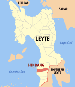
 Map of Leyte with Hindang highlighted | |
.svg.png) Hindang Location within the Philippines | |
| Coordinates: 10°27′N 124°48′E / 10.450°N 124.800°ECoordinates: 10°27′N 124°48′E / 10.450°N 124.800°E | |
| Country | Philippines |
| Region | Eastern Visayas (Region VIII) |
| Province | Leyte |
| Congr. district | 5th district of Leyte |
| Barangays | 20 |
| Government[1] | |
| • Mayor | Betty Cabal |
| Area[2] | |
| • Total | 50.04 km2 (19.32 sq mi) |
| Population (2010)[3] | |
| • Total | 20,179 |
| • Density | 400/km2 (1,000/sq mi) |
| Time zone | PST (UTC+8) |
| ZIP code | 6523 |
| Dialing code | 53 |
Hindang is a fifth class municipality in the province of Leyte, Philippines. In the north, it borders with the town of Inopacan while it borders with the town of Hilongos in the south. According to the 2010 census, it has a population of 20,179 people.[3]
Himokilan and Digyo Islands, part of the Cuatro Islas, are within the administrative jurisdiction of the municipality of Hindang.
Barangays

Sunset at Cuatro Islas
Hindang is politically subdivided into 20 barangays.[2] In 1957, the sitios of Kanhaayon, Kapudlosan, Himokilan, Anolon, Mahilom, Baldoza, and Tagbibi were converted into barrios.[4]
- Anahaw
- Anolon
- Baldoza
- Bontoc
- Bulacan
- Canha-ayon
- Capudlosan
- Himacugo
- Doos Del Norte
- Doos Del Sur
- Himokilan Island
- Katipunan
- Maasin
- Mabagon
- Mahilum
- Poblacion 1
- Poblacion 2
- San Vicente
- Tabok
- Tagbibi
Demographics
| Population census of Hindang | ||
|---|---|---|
| Year | Pop. | ±% p.a. |
| 1990 | 16,272 | — |
| 1995 | 16,567 | +0.34% |
| 2000 | 18,493 | +2.39% |
| 2007 | 19,927 | +1.04% |
| 2010 | 20,179 | +0.46% |
| Source: National Statistics Office[3] | ||
References
- ↑ "Municipalities". Quezon City, Philippines: Department of the Interior and Local Government. Retrieved 24 June 2013.
- 1 2 "Province: Leyte". PSGC Interactive. Makati City, Philippines: National Statistical Coordination Board. Retrieved 2 July 2013.
- 1 2 3 "Total Population by Province, City, Municipality and Barangay: as of May 1, 2010" (PDF). 2010 Census of Population and Housing. National Statistics Office. Retrieved 2 July 2013.
- ↑ "An Act Converting the Sitios of Kanhaayon, Kapudlosan, Himokilan, Anolon, Mahilom, Baldoza and Tagbibi, Municipality of Hindang, Province of Leyte, into Barrios of Said Municipality". LawPH.com. Retrieved 2011-04-12.
External links
| Wikivoyage has a travel guide for Hindang. |
- Philippine Standard Geographic Code
- Philippine Census Information
- Local Governance Performance Management System
- All attractions around the region of Hindang
 |
Inopacan |  | ||
| Camotes Sea | |
Sogod, Southern Leyte | ||
| ||||
| | ||||
| Hilongos |
This article is issued from Wikipedia - version of the 6/1/2016. The text is available under the Creative Commons Attribution/Share Alike but additional terms may apply for the media files.