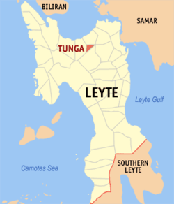
Tunga, Leyte
| Tunga | ||
|---|---|---|
| Municipality | ||
| ||
 Map of Leyte with Tunga highlighted | ||
.svg.png) Tunga Location within the Philippines | ||
| Coordinates: 11°15′N 124°45′E / 11.250°N 124.750°ECoordinates: 11°15′N 124°45′E / 11.250°N 124.750°E | ||
| Country | Philippines | |
| Region | Eastern Visayas (Region VIII) | |
| Province | Leyte | |
| Congr. district | 2nd district of Leyte | |
| Established | November 15, 1949 | |
| Barangays | 8 | |
| Government[1] | ||
| • Mayor | Amando C. Aumento Sr. | |
| Area[2] | ||
| • Total | 7.70 km2 (2.97 sq mi) | |
| Population (2015)[3] | ||
| • Total | 7,584 | |
| • Density | 980/km2 (2,600/sq mi) | |
| Time zone | PST (UTC+8) | |
| ZIP code | 6528 | |
| Dialing code | 53 | |
Tunga is a sixth class municipality in the province of Leyte, Philippines. According to the 2015 census, it has a population of 7,584 people.[3] It is the smallest municipality in Leyte, both in population and area.[2]
Barangays
Tunga is politically subdivided into 8 barangays:[2]
- Astorga (Barrio Upat)
- Balire
- Banawang
- San Antonio (Poblacion)
- San Pedro (Poblacion)
- San Roque (Poblacion)
- San Vicente (Poblacion)
- Sto. Niño (Poblacion)
History
On March 4, 1948, "Pag-urosa han mga Tunga-on", the association that led the campaign to make Tunga a municipality, was organized and it elected Domingo A. Ponferrada, President; Martino Ariza, 1st Vice President; Blas Uribe, 2nd Vice President; Vicente Catenza, 3rd Vice President; Primitivo Geraldo, Secretary; Norberto Quintana, treasurer; Ramón Santillan Sr (died on October 13, 2005, at age 101) and Juan Avila, auditors; Paulo Cotoner, Magno Buñales and Arsenio Carit, Sergeants-at-Arms.
These officers invited and apprised Atilano R. Cinco, Congressman for the 5th District of Leyte, of the desire of Tunga to become an independent municipality. Cinco promised to file a bill in congress when all supporting papers that he had suggested were ready. Thus, a committee on consensus was created. Martino Ariza was elected as chairman; the members being some of the students of Tunga Institute.
Subsequently, Philippine President Quirino issued Executive Order No. 266, dated September 24, 1949, creating the independent municipality of Tunga, however the appointed local officials had to assume their posts a few days after the elections.
On November 15, 1949, Provincial Board Secretary Ricardo Collantes, representing Leyte Governor Catalino Landia, proclaimed the Municipality of Tunga before a huge crowd of joyous Tunga-on and distinguished visitors.
The patron saint of Tunga is Saint Anthony of Padua. The Tunga-on celebrate their town's fiesta on August 13 every year.
Demographics
| Population census of Tunga | ||
|---|---|---|
| Year | Pop. | ±% p.a. |
| 1990 | 5,413 | — |
| 1995 | 6,530 | +3.58% |
| 2000 | 6,111 | −1.41% |
| 2007 | 6,221 | +0.25% |
| 2010 | 6,516 | +1.70% |
| Source: National Statistics Office[4] | ||
Economy
The socio-economic situation in Tunga can be described as poor with little outside investment and few opportunities for most of the municipality's citizens to improve their economic status. Income per capita is very low and the poverty incidence is alarming. The magnitude of families living below the poverty threshold is much too high. The under-employment rate is high and most people hold informal jobs and carry out various activities daily to earn barely a subsistence income for their families. The percent of households without their own dwellings is high.
Elementary education participation is low, reflecting low incomes because families cannot afford to put their children through school and/or children are taken out of school to assist families with income-earning activities. As a result, the simple literacy rate is low.
Crop production indicates very low land productivity with the majority of farmers involved in coconut tree cultivation for copra as their main economic mainstay. Rice cultivation is the second main agricultural activity. Some farmers also raise pigs and chickens to sell to the local meat shop in the local market.
The fish catch, which is mainly Tilapia, in the Tunga River, which flows through the municipality, has decreased since 2005.
References
- ↑ "Municipalities". Quezon City, Philippines: Department of the Interior and Local Government. Retrieved 19 June 2013.
- 1 2 3 "Province: Leyte". PSGC Interactive. Makati City, Philippines: National Statistical Coordination Board. Retrieved 19 June 2013.
- 1 2 "Region VIII (EASTERN VISAYAS)". Census of Population (2015): Total Population by Province, City, Municipality and Barangay (Report). PSA. Retrieved 20 June 2016.
- ↑ "Total Population by Province, City, Municipality and Barangay: as of May 1, 2010" (PDF). 2010 Census of Population and Housing. National Statistics Office. Retrieved 19 June 2013.
External links
- Philippine Standard Geographic Code
- Philippine Census Information
- Local Governance Performance Management System
 |
Barugo |  | ||
| Carigara | |
Jaro | ||
| ||||
| | ||||
| Jaro |
