Jameson, Minnesota
| Jameson, Minnesota | |
|---|---|
| Unincorporated community | |
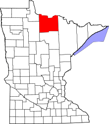
 Jameson, Minnesota  Jameson, Minnesota Location of the community of Jameson | |
| Coordinates: 48°36′14″N 93°21′58″W / 48.60389°N 93.36611°WCoordinates: 48°36′14″N 93°21′58″W / 48.60389°N 93.36611°W | |
| Country | United States |
| State | Minnesota |
| County | Koochiching |
| Elevation | 1,115 ft (340 m) |
| Time zone | Central (CST) (UTC-6) |
| • Summer (DST) | CDT (UTC-5) |
| ZIP code | 56649 |
| Area code(s) | 218 |
| GNIS feature ID | 656771[1] |
Jameson is an unincorporated community in Koochiching County, Minnesota, United States. It is a surrounding community of International Falls, located along the Rainy River.
State Highway 11 (MN 11) is the main route through Jameson, connecting it to the cities of International Falls to the west and Ranier to the east.[2]
Jameson is within the unorganized territory of Rainy Lake, which covers the northeastern part of Koochiching County.[3]
References
- ↑ "Jameson, Minnesota". Geographic Names Information System. United States Geological Survey.
- ↑ Google (1 March 2016). "Jameson, MN" (Map). Google Maps. Google. Retrieved 1 March 2016.
- ↑ "MN county subdivision maps" (PDF). United States Census Bureau.
This article is issued from Wikipedia - version of the 7/28/2016. The text is available under the Creative Commons Attribution/Share Alike but additional terms may apply for the media files.
