Kružberk
| Kružberk | |||
| Municipality | |||
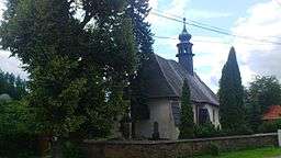
 Church in Kružberk | |||
|
|||
| Country | Czech Republic | ||
|---|---|---|---|
| Region | Moravian-Silesian | ||
| District | Opava | ||
| Elevation | 404 m (1,325 ft) | ||
| Coordinates | CZ 49°50′25″N 17°40′23″E / 49.84028°N 17.67306°ECoordinates: CZ 49°50′25″N 17°40′23″E / 49.84028°N 17.67306°E | ||
| Area | 8.29 km2 (3.20 sq mi) | ||
| Population | 280 (2011) | ||
| Density | 34/km2 (88/sq mi) | ||
| Timezone | CET (UTC+1) | ||
| - summer (DST) | CEST (UTC+2) | ||
| Postal code | 747 86 | ||
  Location in the Czech Republic | |||
| Wikimedia Commons: Kružberk | |||
| Website: www.kruzberk.cz | |||
Kružberk (German: Kreuzberg) is a village in the Moravian-Silesian Region of the Czech Republic. It has around 280 inhabitants and lies 20 km from Opava. The village was first mentioned in a written document in 1377. Kružberk Dam on the Moravice River was constructed in the village in 1948-1955.
External links
This article is issued from Wikipedia - version of the 4/7/2016. The text is available under the Creative Commons Attribution/Share Alike but additional terms may apply for the media files.

