La Courneuve
| La Courneuve | ||
|---|---|---|
|
Town hall | ||
| ||
 Paris and inner ring départements | ||
| Coordinates: 48°55′56″N 2°23′48″E / 48.9322°N 2.3967°ECoordinates: 48°55′56″N 2°23′48″E / 48.9322°N 2.3967°E | ||
| Country | France | |
| Region | Île-de-France | |
| Department | Seine-Saint-Denis | |
| Arrondissement | Saint-Denis | |
| Canton | La Courneuve | |
| Intercommunality | Plaine Commune | |
| Government | ||
| • Mayor (2014–2020) | Gilles Poux | |
| Area1 | 7.52 km2 (2.90 sq mi) | |
| Population (2006)2 | 37,539 | |
| • Density | 5,000/km2 (13,000/sq mi) | |
| Time zone | CET (UTC+1) | |
| • Summer (DST) | CEST (UTC+2) | |
| INSEE/Postal code | 93027 / 93 120 | |
| Elevation |
29–60 m (95–197 ft) (avg. 40 m or 130 ft) | |
|
1 French Land Register data, which excludes lakes, ponds, glaciers > 1 km² (0.386 sq mi or 247 acres) and river estuaries. 2 Population without double counting: residents of multiple communes (e.g., students and military personnel) only counted once. | ||
La Courneuve is a commune in Seine-Saint-Denis, France. It is located 8.3 km (5.2 mi) from the center of Paris.
History
The history of La Courneuve begins, as that of the rest of the region, with the invasion of European tribes and the eventual conquering of the area by the Romans. During the Middle Ages, the area was like many other small villages. With its proximity to Paris, it soon became a fashionable country destination, with a number of gentry residing there. It had two notable châteaux - Sainte-Foi and Poitronville. Towards the end of Napoleon's reign, the entire area experienced large population growth. This along with improved methods of farming eventually transformed the area into the major legume producer for the Paris region.
In 1863, the first major industrial enterprise was introduced and the area soon became a strange mix of factories and farmlands. Industrial estates were juxtaposed with bean plantations and that would continue until after World War II.
During the 1960s, as Paris could no longer meet the demands of a further exploding population (largely the result of immigration from former colonies), La Courneuve, like many other suburbs of Paris, was designated as one of the "zones à urbaniser en priorité" (areas to be urbanized quickly) and was built up at a very rapid pace, with the construction of large council estates and tower blocks and other HLM developments. Between 1962 and 1968 the population nearly doubled.
Heraldry
 |
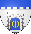
The arms of La Courneuve are blazoned : Azure, a wall embattled argent masoned sable, open to the field contain a millwheel Or above waves argent | |
| motto: droiture et tendresse ("righteousness and tenderness") | ||
Demographics
Immigration
| |||||||||||||||||||
Education
Preschools and primary schools[1]
- Anatole-France
- Charlie-Chaplin
- Irène-Joliot-Curie
- Louise-Michel
- Paul-Doumer
- Paul-Langevin / Henri-Wallon
- Robespierre / Jules-Vallès
- Saint-Exupéry
- Raymond-Poincaré
- Rosenberg
- Joséphine-Baker
- Angela Davis
High schools/junior high schools:[2]
- Collège Raymond-Poincaré
- Collège Jean-Vilar
- Collège Georges-Politzer
Sixth-form colleges/senior high schools:[2]
- Lycée Jacques-Brel
- Lycée d'enseignement professionnel Denis-Papin
- Lycée Arthur-Rimbaud
Transport
La Courneuve is served by La Courneuve – 8 Mai 1945 station on Paris Métro Line 7 and by La Courneuve – Aubervilliers station on Paris RER line B.
Notable people
- Haris Belkebla, Algerian footballer
See also
- Communes of the Seine-Saint-Denis department
- Stade de Marville
References
- ↑ "Écoles maternelle et élémentaire." La Courneuve. Retrieved on August 19, 2016.
- 1 2 "Les collèges et lycées." La Courneuve. Retrieved on August 19, 2016.
- (French) Un peu d'histoire. 07 Feb. 2006. La Ville de La Courneuve
- Mayol, Pierre. "The Policy of the City and Cultural Action". Canadian Journal of Communication Vol. 27, No. 2 (2002)
- (French)Van Renterghem, Marion. "La Courneuve, « Rebeus » et « Renois » disent la vie des « 4000 »." Le Monde, 1 July 2005
External links
| Wikimedia Commons has media related to La Courneuve. |
- Official website
- (French)