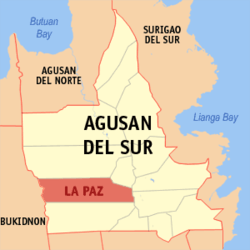
La Paz, Agusan del Sur
| La Paz | |
|---|---|
| Municipality | |
 Location within Agusan del Sur province | |
.svg.png) La Paz Location within the Philippines | |
| Coordinates: 8°17′N 125°49′E / 8.28°N 125.81°ECoordinates: 8°17′N 125°49′E / 8.28°N 125.81°E | |
| Country | Philippines |
| Region | Caraga (Region XIII) |
| Province | Agusan del Sur |
| District | 2nd district of Agusan del Sur |
| Barangays | 15 (see Barangays) |
| Government [1] | |
| • Type | Sangguniang Bayan |
| • Mayor | Ambrosio O. Lim |
| Area[2] | |
| • Total | 1,481.12 km2 (571.86 sq mi) |
| Population (2015 census)[3] | |
| • Total | 28,217 |
| • Density | 19/km2 (49/sq mi) |
| • Voter (2016)[4] | 17,584 |
| Time zone | PST (UTC+8) |
| ZIP code | 8508 |
| IDD : area code | +63 (0)85 |
| Income class | 1st class |
| PSGC | 160304000 |
| Website |
elgu |
La Paz, officially the Municipality of La Paz (Filipino: Bayan ng La Paz), is a municipality in the province of Agusan del Sur in the Caraga (Region XIII) of the Philippines. The population was 28,217 at the 2015 census.[3] In the 2016 election, it had 17,584 registered voters.[4]
Geography
La Paz is located at 8°17′N 125°49′E / 8.28°N 125.81°E.
According to the Philippine Statistics Authority, the municipality has a land area of 1,481.12 square kilometres (571.86 sq mi)[2] constituting 14.83% of the 9,989.52-square-kilometre- (3,856.98 sq mi) total area of Agusan del Sur.
Barangays
La Paz is politically subdivided into 15 barangays.[5]
| PSGC | Barangay | Population | ±% p.a. | ||
|---|---|---|---|---|---|
| 2015[3] | 2010[6] | ||||
| 160304009 | Angeles | 2.9% | 823 | 1,039 | −4.34% |
| 160304001 | Bataan | 6.7% | 1,893 | 1,685 | +2.24% |
| 160304002 | Comota | 5.8% | 1,641 | 2,046 | −4.11% |
| 160304003 | Halapitan | 1.8% | 508 | 639 | −4.27% |
| 160304010 | Kasapa II | 5.0% | 1,398 | 1,391 | +0.10% |
| 160304004 | Langasian | 4.4% | 1,233 | 1,083 | +2.50% |
| 160304011 | Lydia | 5.2% | 1,465 | 1,579 | −1.42% |
| 160304005 | Osmeña, Sr. | 6.5% | 1,827 | 1,553 | +3.14% |
| 160304012 | Panagangan | 12.6% | 3,549 | 3,319 | +1.28% |
| 160304006 | Poblacion | 19.7% | 5,563 | 4,977 | +2.14% |
| 160304013 | Sabang Adgawan | 5.3% | 1,505 | 1,667 | −1.93% |
| 160304007 | Sagunto | 5.9% | 1,677 | 1,847 | −1.82% |
| 160304014 | San Patricio | 5.2% | 1,476 | 1,358 | +1.60% |
| 160304015 | Valentina | 6.9% | 1,942 | 2,560 | −5.12% |
| 160304008 | Villa Paz | 6.1% | 1,717 | 1,819 | −1.09% |
| Total | 28,217 | 28,562 | −0.23% | ||
Demographics
| Population census of La Paz | |||||||||||||||||||||||||
|---|---|---|---|---|---|---|---|---|---|---|---|---|---|---|---|---|---|---|---|---|---|---|---|---|---|
|
| ||||||||||||||||||||||||
| Source: PSA[3][6][7] | |||||||||||||||||||||||||
In the 2015 census, La Paz had a population of 28,217.[3] The population density was 19 inhabitants per square kilometre (49/sq mi).
In the 2016 election, it had 17,584 registered voters.[4]
References
- ↑ "Municipality". Quezon City, Philippines: Department of the Interior and Local Government. Retrieved 31 May 2013.
- 1 2 "Province: Agusan del Sur". PSGC Interactive. Makati City, Philippines: Philippine Statistics Authority. Retrieved 28 October 2016.
- 1 2 3 4 5 "CARAGA". Census of Population (2015): Total Population by Province, City, Municipality and Barangay (Report). PSA. Retrieved 20 June 2016.
- 1 2 3 "2016 National and Local Elections Statistics". Commission on Elections. 2016.
- ↑ "Municipal: La Paz, Agusan del Sur". PSGC Interactive. Quezon City, Philippines: Philippine Statistics Authority. Retrieved 8 January 2016.
- 1 2 "CARAGA". Census of Population and Housing (2010): Total Population by Province, City, Municipality and Barangay (Report). NSO. Retrieved 29 June 2016.
- ↑ "CARAGA". Census of Population (1995, 2000 and 2007): Total Population by Province, City and Municipality (Report). NSO. Archived from the original on 11 November 2011.
 |
San Luis / Talacogon | Rosario |  | |
| Malaybalay, Bukidnon | |
|||
| ||||
| | ||||
| Loreto | Bunawan |