List of listed buildings in Johnstone, Renfrewshire
This is a list of listed buildings in the parish of Johnstone in Renfrewshire, Scotland.
List
| Name | Location | Date Listed | Grid Ref. [note 1] | Geo-coordinates | Notes | HB Number [note 2] | Image |
|---|---|---|---|---|---|---|---|
| Tower At Rear Of Red House, Cochranemill Road | 55°49′17″N 4°31′36″W / 55.821374°N 4.526665°W | Category C(S) | 35603 | 
| |||
| 62 High Street | 55°50′14″N 4°30′49″W / 55.837118°N 4.513663°W | Category C(S) | 35605 |
| |||
| Moorburn, Old Auchengreoch Road, Johnstone, With Summerhouse, Boundary Walls, Gatepiers And Gates | 55°49′07″N 4°31′29″W / 55.818563°N 4.524822°W | Category B | 35622 |
| |||
| Park Road,Laigh Park Including Ancillary Structure, Boundary Walls, Gatepiers And Gates | 55°49′55″N 4°30′38″W / 55.831843°N 4.510544°W | Category C(S) | 48033 |
| |||
| Park Road, The Grange Including Boundary Walls, Gatepiers And Gates | 55°49′49″N 4°30′52″W / 55.830265°N 4.514322°W | Category C(S) | 48614 |
| |||
| Johnstone Mill, High Street | 55°50′17″N 4°31′06″W / 55.837957°N 4.518365°W | Category A | 35610 |
| |||
| Quarry Street, High Parish Church. (Including Graveyard, Etc.) | 55°50′03″N 4°30′53″W / 55.834158°N 4.514686°W | Category B | 35612 | 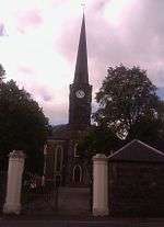
| |||
| Thorn Inn, Thornhill, | 55°50′02″N 4°29′54″W / 55.833945°N 4.498254°W | Category C(S) | 35613 |
| |||
| Former Police Station, 9 Collier Street, Johnstone | 55°50′15″N 4°30′47″W / 55.837457°N 4.512934°W | Category C(S) | 35617 |
| |||
| Johnstone Castle, Off Beith Road | 55°49′40″N 4°30′27″W / 55.827877°N 4.507557°W | Category B | 35602 |
| |||
| St. John The Evangelists' Episcopal Church, Floors Street | 55°49′59″N 4°31′00″W / 55.83318°N 4.516794°W | Category B | 35604 |
| |||
| 67 High Street | 55°50′13″N 4°30′51″W / 55.836962°N 4.514244°W | Category C(S) | 35621 |
| |||
| 64 High Street | 55°50′14″N 4°30′50″W / 55.837141°N 4.513872°W | Category C(S) | 35606 |
| |||
| 68 High Street | 55°50′14″N 4°30′51″W / 55.837223°N 4.514261°W | Category C(S) | 35608 |
| |||
| The Bird In The Hand, Hotel Quarrelton | 55°49′45″N 4°30′46″W / 55.829064°N 4.512824°W | Category B | 35611 |
| |||
| Houston Square,Bandstand | 55°50′11″N 4°30′44″W / 55.836456°N 4.512215°W | Category B | 35615 | 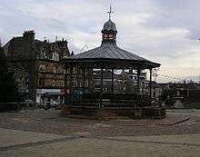
| |||
| Houston Saint Johnstone, Masonic Lodge 11 Collier Street, Dwarf Walls And Gatepiers | 55°50′16″N 4°30′48″W / 55.837649°N 4.513218°W | Category B | 35618 |
| |||
| 63 High Street | 55°50′13″N 4°30′50″W / 55.836926°N 4.51381°W | Category C(S) | 35619 |
| |||
| 65 High Street | 55°50′13″N 4°30′50″W / 55.836914°N 4.513985°W | Category C(S) | 35620 |
| |||
| 66 High Street | 55°50′14″N 4°30′51″W / 55.8372°N 4.514067°W | Category C(S) | 35607 |
| |||
| Former Burgh Chambers, 7 Collier Street, Johnstone | 55°50′14″N 4°30′47″W / 55.837328°N 4.513069°W | Category B | 35616 |
| |||
| New Globe Bingo And Social Club (Former Globe Cinema) 7 And 9 High Street | 55°50′09″N 4°30′28″W / 55.8357°N 4.507854°W | Category C(S) | 51168 |
| |||
| 70 High Street | 55°50′14″N 4°30′52″W / 55.837245°N 4.514502°W | Category C(S) | 35609 |
|
Key
The scheme for classifying buildings in Scotland is:
- Category A: "buildings of national or international importance, either architectural or historic, or fine little-altered examples of some particular period, style or building type."[1]
- Category B: "buildings of regional or more than local importance, or major examples of some particular period, style or building type which may have been altered."[1]
- Category C(S): "buildings of local importance, lesser examples of any period, style, or building type, as originally constructed or moderately altered; and simple traditional buildings which group well with others in categories A and B."[1]
There are approximately 47,400 listed buildings in Scotland. Of these, around 8 per cent (some 3,800) are Category A, and 51 per cent (24,000) are Category B, with the rest listed at Category C(s).[2]
Notes
- ↑ Sometimes known as OSGB36, the grid reference (where provided) is based on the British national grid reference system used by the Ordnance Survey.
• "Guide to National Grid". Ordnance Survey. Retrieved 2007-12-12.
• "Get-a-map". Ordnance Survey. Retrieved 2007-12-17. - ↑ The "HB Number" is a unique number assigned to each listed building by Historic Scotland.
References
- All entries, addresses and coordinates are based on data from Historic Scotland. This data falls under the Open Government Licence
- 1 2 3 "What is Listing?". Historic Scotland. Retrieved 2010-07-06.
- ↑ Guide to the Protection of Scotland’s Listed Buildings (PDF). Historic Scotland. 2009. p. 17. ISBN 978-1-84917-013-0. Retrieved 2010-07-06.
This article is issued from Wikipedia - version of the 10/15/2016. The text is available under the Creative Commons Attribution/Share Alike but additional terms may apply for the media files.