Mâncio Lima
Coordinates: 07°36′50″S 72°53′45″W / 7.61389°S 72.89583°W
| Mâncio Lima | |||
|---|---|---|---|
 | |||
| |||
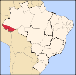
 Location of municipality in Acre State | |||
 Mâncio Lima Location in Brazil | |||
| Coordinates: 07°36′50″S 72°53′45″W / 7.61389°S 72.89583°W | |||
| Country |
| ||
| State | Acre | ||
| Area | |||
| • Total | 1,804 sq mi (4,672 km2) | ||
| Population (2007) | |||
| • Total | 13 785 | ||
Mâncio Lima is the westernmost municipality of Brazil and it is located in the state of Acre. It is also the northernmost city of that state. Its population is 13,785 and its area is 4,672 km². Its counterparts in the North, South and East are respectively Uiramutã, state of Roraima; Chuí, Rio Grande do Sul; and João Pessoa, Paraíba.
The municipality contains 32% of the 846,633 hectares (2,092,080 acres) Serra do Divisor National Park, created in 1989.[1]
References
- ↑ PARNA da Serra do Divisor (in Portuguese), ISA: Instituto Socioambiental, retrieved 2016-08-08
External links
![]() Media related to Mâncio Lima at Wikimedia Commons
Media related to Mâncio Lima at Wikimedia Commons
This article is issued from Wikipedia - version of the 10/30/2016. The text is available under the Creative Commons Attribution/Share Alike but additional terms may apply for the media files.


