| [3] |
Name on the Register[4] |
Image |
Date listed[5] |
Location |
City or town |
Description |
|---|
| 1 |
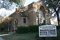
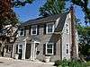
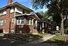
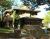
A.J. Andrus Duplex |
|
000000001980-01-29-0000January 29, 1980
(#80001431) |
687-691 E. State St.
43°09′06″N 93°12′00″W / 43.151667°N 93.2°W / 43.151667; -93.2 (A.J. Andrus Duplex) |
Mason City |
|
| 2 |
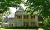
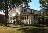
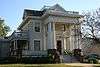
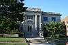
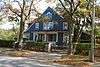
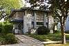
Amaziah and Cornelia (Wait) Cannon House |
|
000000002004-08-25-0000August 25, 2004
(#04000899) |
1581 N. Eisenhower Ave.
43°10′10″N 93°15′36″W / 43.169444°N 93.26°W / 43.169444; -93.26 (Amaziah and Cornelia (Wait) Cannon House) |
Mason City |
|
| 3 |
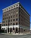
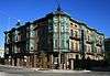
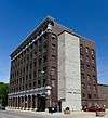
City National Bank Building |
|
000000001972-09-14-0000September 14, 1972
(#72000469) |
4 S. Federal Ave.
43°09′05″N 93°22′04″W / 43.151389°N 93.367778°W / 43.151389; -93.367778 (City National Bank Building) |
Mason City |
|
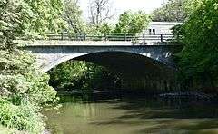
| 4 |
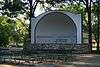
East Park Band Shell |
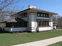
|
000000002009-10-14-0000October 14, 2009
(#09000825) |
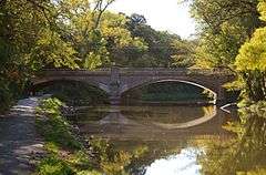
E. State St. between N. Carolina Ave. and N. Kentucky Ave.
43°09′09″N 93°11′01″W / 43.152425°N 93.183586°W / 43.152425; -93.183586 (East Park Band Shell) |
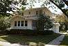
Mason City |
|
| 5 |
East Park Historic District |
|
000000002014-10-15-0000October 15, 2014
(#14000855) |
Roughly bounded by the Winnebago R., N. Carolina, N. Kentucky & N. Virginia Aves., CPRR tracks, E. State St.
43°09′20″N 93°11′02″W / 43.155672°N 93.183967°W / 43.155672; -93.183967 (East Park Historic District) |
Mason City |
|
| 6 |
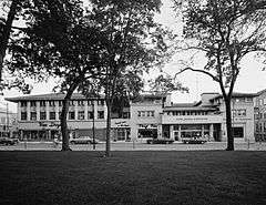
Elks-Rogers Hotel |
Upload image |
000000001982-06-21-0000June 21, 1982
(#82002611) |
223 Main Ave.
43°08′08″N 93°22′54″W / 43.135556°N 93.381667°W / 43.135556; -93.381667 (Elks-Rogers Hotel) |
Clear Lake |
|
| 7 |
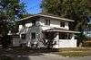
John L. Etzel House |
Upload image |
000000001983-01-27-0000January 27, 1983
(#83000347) |
214 N. 3rd St.
43°08′15″N 93°22′58″W / 43.1375°N 93.382778°W / 43.1375; -93.382778 (John L. Etzel House) |
Clear Lake |
|
| 8 |
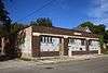
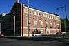
First Church of Christ Scientist |
|
000000001997-10-30-0000October 30, 1997
(#97001285) |
23 3rd St., NW.
43°09′18″N 93°04′16″W / 43.155°N 93.071111°W / 43.155; -93.071111 (First Church of Christ Scientist) |
Mason City |
|
| 9 |
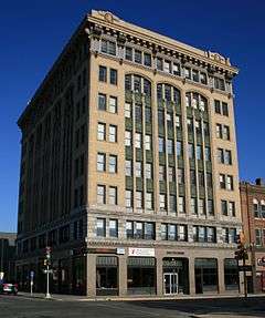
First National Bank of Mason City |
|
000000001997-05-02-0000May 2, 1997
(#97000392) |
5-7 N. Federal Ave.
43°09′40″N 93°12′00″W / 43.161111°N 93.2°W / 43.161111; -93.2 (First National Bank of Mason City) |
Mason City |
|
| 10 |
Forest Park Historic District |
|
000000002015-01-20-0000January 20, 2015
(#14001167) |
Roughly bounded by Willow Cr., Crescent & Linden Drs., State St., S. Pierce & N. Taylor Aves., 1st St. SW.
43°09′14″N 93°13′02″W / 43.154°N 93.2173°W / 43.154; -93.2173 (Forest Park Historic District) |
Mason City |
|
| 11 |
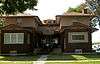
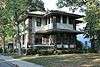
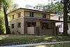
C.F. Franke House |
|
000000001980-01-29-0000January 29, 1980
(#80001432) |
320 1st St., SE.
43°09′04″N 93°12′25″W / 43.151111°N 93.206944°W / 43.151111; -93.206944 (C.F. Franke House) |
Mason City |
|
| 12 |
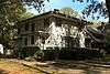
E.R. Gibson House |
|
000000001980-01-29-0000January 29, 1980
(#80001433) |
114 4th St., NW.
43°09′20″N 93°12′55″W / 43.155556°N 93.215278°W / 43.155556; -93.215278 (E.R. Gibson House) |
Mason City |
|
| 13 |
Hotel Lester-Lester Cafe |
|
000000002002-12-20-0000December 20, 2002
(#02001543) |
408-410 2nd St., NW.
43°09′14″N 93°12′30″W / 43.153889°N 93.208333°W / 43.153889; -93.208333 (Hotel Lester-Lester Cafe) |
Mason City |
|
| 14 |
Jewell Apartments |
|
000000001980-01-29-0000January 29, 1980
(#80001434) |
404-412 1st St., NW.
43°09′10″N 93°13′11″W / 43.152778°N 93.219722°W / 43.152778; -93.219722 (Jewell Apartments) |
Mason City |
|
| 15 |
Keerl-Decker House |
|
000000002002-12-20-0000December 20, 2002
(#02001537) |
119 2nd St., SE.
43°09′00″N 93°11′54″W / 43.15°N 93.198333°W / 43.15; -93.198333 (Keerl-Decker House) |
Mason City |
|
| 16 |
The Kirk |
|
000000001982-04-12-0000April 12, 1982
(#82002613) |
206 N. Federal Ave.
43°09′13″N 93°12′06″W / 43.153611°N 93.201667°W / 43.153611; -93.201667 (The Kirk) |
Mason City |
|
| 17 |
Lippert House |
|
000000001980-01-29-0000January 29, 1980
(#80001435) |
122-124 N. Madison Ave.
43°09′12″N 93°13′11″W / 43.153333°N 93.219722°W / 43.153333; -93.219722 (Lippert House) |
Mason City |
|
| 18 |
Mason City Downtown Historic District |
|
000000002005-09-08-0000September 8, 2005
(#05000956) |
Roughly bounded by N. 46th St., Georgia Ave., Washington Ave., and S. 2nd St.
43°09′25″N 93°12′00″W / 43.156944°N 93.2°W / 43.156944; -93.2 (Mason City Downtown Historic District) |
Mason City |
|
| 19 |
Mason City Public Library |
|
000000001989-05-25-0000May 25, 1989
(#89000405) |
208 E. State St.
43°09′07″N 93°03′01″W / 43.151944°N 93.050278°W / 43.151944; -93.050278 (Mason City Public Library) |
Mason City |
|
| 20 |
Mason City YMCA |
|
000000002002-05-02-0000May 2, 2002
(#02000426) |
15 N. Pennsylvania
43°09′09″N 93°11′50″W / 43.1525°N 93.197222°W / 43.1525; -93.197222 (Mason City YMCA) |
Mason City |
|
| 21 |
MBA (Modern Brotherhood of America) Building |
|
000000002002-09-12-0000September 12, 2002
(#02001021) |
103 E. State St.
43°09′06″N 93°11′56″W / 43.151667°N 93.198889°W / 43.151667; -93.198889 (MBA (Modern Brotherhood of America) Building) |
Mason City |
|
| 22 |
F.M. Norris House |
Upload image |
000000001980-01-29-0000January 29, 1980
(#80001436) |
108 4th St., NE.
43°09′20″N 93°12′41″W / 43.155556°N 93.211389°W / 43.155556; -93.211389 (F.M. Norris House) |
Mason City |
|
| 23 |
Park Inn Hotel |
|
000000001972-09-14-0000September 14, 1972
(#72000470) |
15 W. State St.
43°09′05″N 93°22′04″W / 43.151389°N 93.367778°W / 43.151389; -93.367778 (Park Inn Hotel) |
Mason City |
|
| 24 |
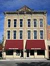
Parker's Opera House |
|
000000001998-11-20-0000November 20, 1998
(#98001325) |
23 N. Federal Ave.
43°09′10″N 93°12′02″W / 43.152778°N 93.200556°W / 43.152778; -93.200556 (Parker's Opera House) |
Mason City |
|
| 25 |
Parker's Woods Park Historic District |
|
000000002014-10-15-0000October 15, 2014
(#14000856) |
N. Jackson Ave. between 1st & 4th Sts., NW.
43°09′15″N 93°12′45″W / 43.154183°N 93.212592°W / 43.154183; -93.212592 (Parker's Woods Park Historic District) |
Mason City |
|
| 26 |
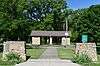
Rock Crest – Rock Glen Historic District |
Upload image |
000000001979-12-28-0000December 28, 1979
(#79000885) |
Off U.S. Route 18
43°09′02″N 93°11′32″W / 43.150556°N 93.192222°W / 43.150556; -93.192222 (Rock Crest – Rock Glen Historic District) |
Mason City |
|
| 27 |
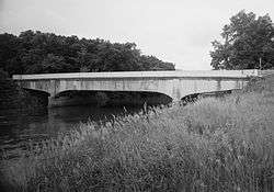
Rock Falls Bridge |
Upload image |
000000001998-06-25-0000June 25, 1998
(#98000742) |
Spring St. over the Shell Rock River
43°12′24″N 93°05′04″W / 43.206667°N 93.084444°W / 43.206667; -93.084444 (Rock Falls Bridge) |
Rock Falls |
|
| 28 |
Rogers-Knutson House |
|
000000001982-09-09-0000September 9, 1982
(#82002612) |
315 N. 3rd St.
43°08′19″N 93°23′06″W / 43.138611°N 93.385°W / 43.138611; -93.385 (Rogers-Knutson House) |
Clear Lake |
|
| 29 |
George Romey House |
|
000000001980-01-29-0000January 29, 1980
(#80001437) |
428 1st St., SE.
43°09′04″N 93°12′20″W / 43.151111°N 93.205556°W / 43.151111; -93.205556 (George Romey House) |
Mason City |
|
| 30 |
Duncan Rule House |
|
000000001979-10-16-0000October 16, 1979
(#79000886) |
321 2nd St., SE.
43°08′59″N 93°11′44″W / 43.149722°N 93.195556°W / 43.149722; -93.195556 (Duncan Rule House) |
Mason City |
|
| 31 |
Chris Rye House |
|
000000001980-01-29-0000January 29, 1980
(#80001438) |
630 E. State St.
43°09′08″N 93°12′05″W / 43.152222°N 93.201389°W / 43.152222; -93.201389 (Chris Rye House) |
Mason City |
|
| 32 |
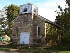
St. John Baptist Church |
|
000000002002-01-24-0000January 24, 2002
(#01001484) |
715 6th St., SW.
43°07′55″N 93°12′42″W / 43.131944°N 93.211667°W / 43.131944; -93.211667 (St. John Baptist Church) |
Mason City |
|
| 33 |
Charles Seney House |
|
000000001980-01-29-0000January 29, 1980
(#80001439) |
109 7th St., NW. and 622 N. Washington St.
43°09′29″N 93°12′54″W / 43.158056°N 93.215°W / 43.158056; -93.215 (Charles Seney House) |
Mason City |
|
| 34 |
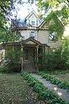
C.P. Shipley House |
Upload image |
000000001980-01-29-0000January 29, 1980
(#80001440) |
114 3rd St., NW.
43°09′17″N 93°12′55″W / 43.154722°N 93.215278°W / 43.154722; -93.215278 (C.P. Shipley House) |
Mason City |
|
| 35 |
State Street Bridge |
|
000000001998-06-25-0000June 25, 1998
(#98000740) |
E. State St. over Willow Creek
43°09′07″N 93°11′29″W / 43.151944°N 93.191389°W / 43.151944; -93.191389 (State Street Bridge) |
Mason City |
|
| 36 |
Stewart Avenue Bridge |
|
000000001998-06-25-0000June 25, 1998
(#98000741) |
North Carolina Ave. over the Winnebago River
43°09′24″N 93°11′25″W / 43.156667°N 93.190278°W / 43.156667; -93.190278 (Stewart Avenue Bridge) |
Mason City |
|
| 37 |
Dr. G.C. Stockman House |
|
000000001992-09-17-0000September 17, 1992
(#80001441) |
311 1st St., SE.
43°09′10″N 93°11′31″W / 43.15265°N 93.191981°W / 43.15265; -93.191981 (Dr. G.C. Stockman House) |
Mason City |
|
| 38 |
Surf Ballroom |
|
000000002011-09-06-0000September 6, 2011
(#10000261) |
460 N Shore Dr
43°08′24″N 93°23′22″W / 43.14°N 93.389444°W / 43.14; -93.389444 (Surf Ballroom) |
Clear Lake |
|
| 39 |
Wagner-Mozart Music Hall |
Upload image |
000000001978-11-16-0000November 16, 1978
(#78001210) |
1st St., NE. and Delaware Ave.
43°09′09″N 93°11′56″W / 43.1525°N 93.198889°W / 43.1525; -93.198889 (Wagner-Mozart Music Hall) |
Mason City |
|
| 40 |
Winnebago River Bridge |
|
000000001998-06-25-0000June 25, 1998
(#98000812) |
U.S. Route 65 over the Winnebago River
43°11′35″N 93°12′37″W / 43.193056°N 93.210278°W / 43.193056; -93.210278 (Winnebago River Bridge) |
Mason City |
|
| 41 |
Mier Wolf House |
|
000000001980-01-29-0000January 29, 1980
(#80001442) |
811 N. Adams St.
43°09′34″N 93°12′58″W / 43.159444°N 93.216111°W / 43.159444; -93.216111 (Mier Wolf House) |
Mason City |
|
| 42 |
Curtis Yelland House |
|
000000001980-01-29-0000January 29, 1980
(#80001443) |
37 River Heights Dr.
43°08′55″N 93°12′22″W / 43.148611°N 93.206111°W / 43.148611; -93.206111 (Curtis Yelland House) |
Mason City |
|
| 43 |
Tessa Youngblood House |
|
000000001980-01-29-0000January 29, 1980
(#80001444) |
36 Oak Dr.
43°09′05″N 93°13′32″W / 43.151389°N 93.225556°W / 43.151389; -93.225556 (Tessa Youngblood House) |
Mason City |
|