| [3] |
Name on the Register[4] |
Image |
Date listed[5] |
Location |
City or town |
Description |
|---|
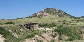
| 1 |
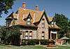
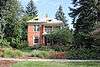
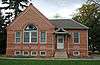
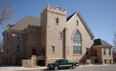
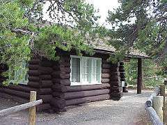
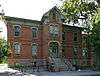
Ammons Hall |
|
000000001978-06-15-0000June 15, 1978
(#78000864) |
Colorado State University campus
40°34′40″N 105°04′52″W / 40.577778°N 105.081111°W / 40.577778; -105.081111 (Ammons Hall) |
Fort Collins |
|
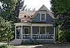
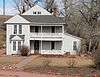
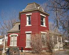
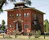
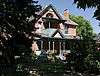
| 2 |
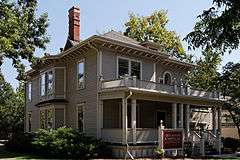
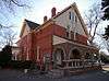
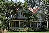
Peter Anderson House |
|
000000001979-10-25-0000October 25, 1979
(#79000614) |
300 S. Howes St.
40°35′02″N 105°04′47″W / 40.583889°N 105.079722°W / 40.583889; -105.079722 (Peter Anderson House) |
Fort Collins |
|
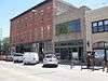
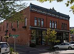
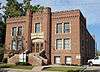
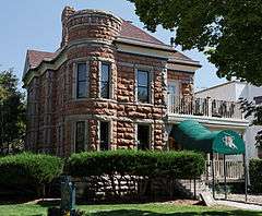
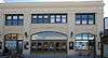
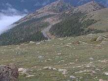
| 3 |
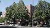
Armstrong Hotel |
|
000000002000-08-31-0000August 31, 2000
(#00001002) |
249-261 S. College Ave.
40°35′04″N 105°04′36″W / 40.584444°N 105.076667°W / 40.584444; -105.076667 (Armstrong Hotel) |
Fort Collins |
|
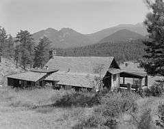
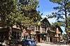
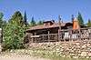
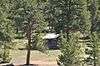
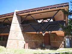
| 4 |
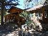
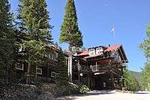
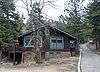
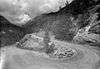
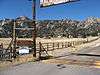
Arrowhead Lodge |
|
000000001992-05-27-0000May 27, 1992
(#92000502) |
34500 Poudre Canyon Highway in the Roosevelt National Forest
40°42′13″N 105°38′09″W / 40.703611°N 105.635833°W / 40.703611; -105.635833 (Arrowhead Lodge) |
Bellvue |
|
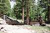
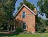
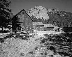
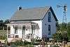
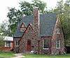
| 5 |
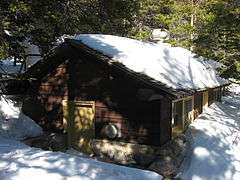
Avery House |
|
000000001972-06-24-0000June 24, 1972
(#72000274) |
328 W. Mountain Ave.
40°35′14″N 105°04′53″W / 40.587222°N 105.081389°W / 40.587222; -105.081389 (Avery House) |
Fort Collins |
|
| 6 |
Baker House |
|
000000001978-07-20-0000July 20, 1978
(#78000866) |
304-304½ E. Mulberry St.
40°34′54″N 105°04′24″W / 40.581667°N 105.073333°W / 40.581667; -105.073333 (Baker House) |
Fort Collins |
|
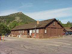
| 7 |
Baldpate Inn |
|
000000001996-01-11-0000January 11, 1996
(#95001510) |
4900 S. State Highway 7
40°18′30″N 105°32′04″W / 40.3083°N 105.5344°W / 40.3083; -105.5344 (Baldpate Inn) |
Estes Park |
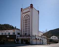
|
| 8 |
Bear Lake Comfort Station |
|
000000001988-01-29-0000January 29, 1988
(#87001137) |
Bear Lake
40°18′44″N 105°38′42″W / 40.312222°N 105.645°W / 40.312222; -105.645 (Bear Lake Comfort Station) |
Estes Park |
|
| 9 |
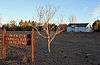
Bee Farm |
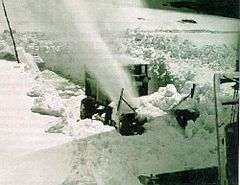
Upload image |
000000002002-11-25-0000November 25, 2002
(#02001409) |
4320 E. County Road 58
40°40′17″N 104°59′42″W / 40.671389°N 104.995°W / 40.671389; -104.995 (Bee Farm) |
Fort Collins |
|
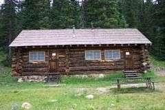
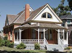
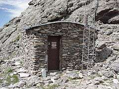
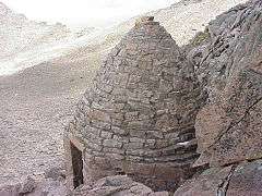
| 10 |
A. S. Benson House |
|
000000002004-01-06-0000January 6, 2004
(#03001362) |
463 W. 5th St.
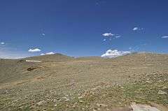
40°23′48″N 105°04′56″W / 40.396667°N 105.082222°W / 40.396667; -105.082222 (A. S. Benson House) |
Loveland |
|
| 11 |
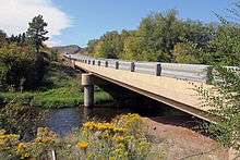
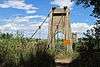
Big Thompson River Bridge III |
|
000000002002-10-15-0000October 15, 2002
(#02001139) |
U.S. Highway 34 at milepost 85.15
40°24′54″N 105°11′42″W / 40.415°N 105.195°W / 40.415; -105.195 (Big Thompson River Bridge III) |
Loveland |
|
| 12 |
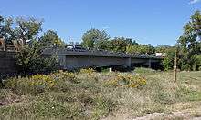
Big Thompson River Bridge IV |
|
000000002002-10-15-0000October 15, 2002
(#02001140) |
U.S. Highway 34 at milepost 86.04
40°25′07″N 105°10′47″W / 40.418611°N 105.179722°W / 40.418611; -105.179722 (Big Thompson River Bridge IV) |
Loveland |
|
| 13 |
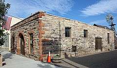
Bimson Blacksmith Shop |
|
000000001981-07-23-0000July 23, 1981
(#81000185) |
224 Mountain St.
40°18′21″N 105°04′32″W / 40.305833°N 105.075556°W / 40.305833; -105.075556 (Bimson Blacksmith Shop) |
Berthoud |
|
| 14 |
Bingham Homestead Rural Historic Landscape |
Upload image |
000000002013-04-16-0000April 16, 2013
(#13000161) |
4916 Bingham Hill Rd.
40°37′33″N 105°10′07″W / 40.625907°N 105.168732°W / 40.625907; -105.168732 (Bingham Homestead Rural Historic Landscape) |
Bellvue |
|
| 15 |
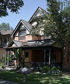
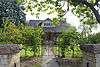
Maude Stanfield Harter Borland House |
|
000000002004-07-06-0000July 6, 2004
(#04000662) |
610 N. Jefferson Ave.
40°23′52″N 105°04′16″W / 40.397778°N 105.071111°W / 40.397778; -105.071111 (Maude Stanfield Harter Borland House) |
Loveland |
|
| 16 |
Botanical and Horticultural Laboratory |
|
000000001978-09-18-0000September 18, 1978
(#78003395) |
Colorado State University campus
40°34′40″N 105°04′40″W / 40.577778°N 105.077778°W / 40.577778; -105.077778 (Botanical and Horticultural Laboratory) |
Fort Collins |
Now called Routt Hall.
|
| 17 |
Jay H. Bouton House |
|
000000001978-12-18-0000December 18, 1978
(#78000867) |
113 N. Sherwood St.
40°35′15″N 105°05′04″W / 40.5875°N 105.084444°W / 40.5875; -105.084444 (Jay H. Bouton House) |
Fort Collins |
|
| 18 |
Buckeye School |
|
000000002008-06-26-0000June 26, 2008
(#08000599) |
Off W. County Road 80
40°49′35″N 105°05′36″W / 40.82648°N 105.09339°W / 40.82648; -105.09339 (Buckeye School) |
Wellington |
|
| 19 |
Chasteen's Grove |
Upload image |
000000001978-09-06-0000September 6, 1978
(#78000872) |
West of Loveland off U.S. Highway 34
40°25′23″N 105°12′13″W / 40.423056°N 105.203611°W / 40.423056; -105.203611 (Chasteen's Grove) |
Loveland |
|
| 20 |
Clatworthy Place |
|
000000002004-07-14-0000July 14, 2004
(#04000681) |
225 Cyteworth Rd.
40°22′21″N 105°31′17″W / 40.3725°N 105.521389°W / 40.3725; -105.521389 (Clatworthy Place) |
Estes Park |
|
| 21 |
Colorado and Southern Railway Depot |
|
000000001982-06-14-0000June 14, 1982
(#82002303) |
405 Railroad Ave.
40°23′46″N 105°04′31″W / 40.396111°N 105.075278°W / 40.396111; -105.075278 (Colorado and Southern Railway Depot) |
Loveland |
|
| 22 |
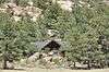
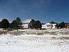
Crags Lodge |
|
000000001998-07-01-0000July 1, 1998
(#98000814) |
300 Riverside Dr.
40°22′12″N 105°31′25″W / 40.37°N 105.5236°W / 40.37; -105.5236 (Crags Lodge) |
Estes Park |
|
| 23 |
Downtown Loveland Historic District |
|
000000002015-06-01-0000June 1, 2015
(#15000281) |
Roughly bounded by Railroad & Jefferson Aves., alleys between 3rd & 4th Sts. & 4th & 5th Sts.
40°23′44″N 105°04′27″W / 40.3955°N 105.0741°W / 40.3955; -105.0741 (Downtown Loveland Historic District) |
Loveland |
|
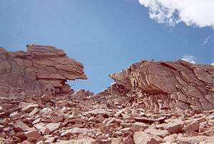
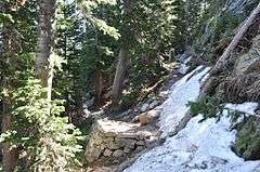
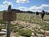
| 24 |
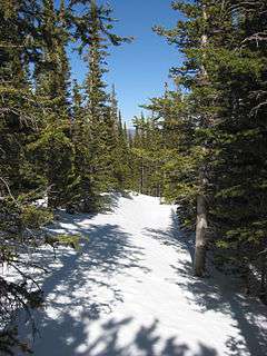
East Longs Peak Trail-Longs Peak Trail-Keyhole Route-Shelf Trail |
|
000000002007-07-10-0000July 10, 2007
(#07000740) |
West of State Highway 7[6]
40°16′20″N 105°36′02″W / 40.272222°N 105.600556°W / 40.272222; -105.600556 (East Longs Peak Trail-Longs Peak Trail-Keyhole Route-Shelf Trail) |
Allenspark |
Extends into Boulder County.
|
| 25 |
Edgemont |
|
000000001998-07-15-0000July 15, 1998
(#98000853) |
1861 Mary's Lake Rd.
40°21′02″N 105°32′21″W / 40.3506°N 105.5392°W / 40.3506; -105.5392 (Edgemont) |
Estes Park |
|
| 26 |
Elkhorn Lodge |
|
000000001978-12-27-0000December 27, 1978
(#78000862) |
530 W. Elkhorn Ave.
40°22′38″N 105°32′00″W / 40.3772°N 105.5333°W / 40.3772; -105.5333 (Elkhorn Lodge) |
Estes Park |
|
| 27 |
Fall River Entrance Historic District |
|
000000001988-01-29-0000January 29, 1988
(#87001139) |
Fall River Entrance
40°24′11″N 105°35′13″W / 40.40312°N 105.58707°W / 40.40312; -105.58707 (Fall River Entrance Historic District) |
Estes Park |
|
| 28 |
Fall River Pass Ranger Station |
|
000000001988-01-29-0000January 29, 1988
(#87001140) |
Fall River Pass
40°26′27″N 105°45′13″W / 40.440833°N 105.753611°W / 40.440833; -105.753611 (Fall River Pass Ranger Station) |
Estes Park |
|
| 29 |
Fall River Pump House and Catchment Basin |
|
000000002006-08-30-0000August 30, 2006
(#06000735) |
Near the top of Fall River Road in Rocky Mountain National Park
40°26′15″N 105°44′50″W / 40.4375°N 105.747222°W / 40.4375; -105.747222 (Fall River Pump House and Catchment Basin) |
Estes Park |
|
| 30 |
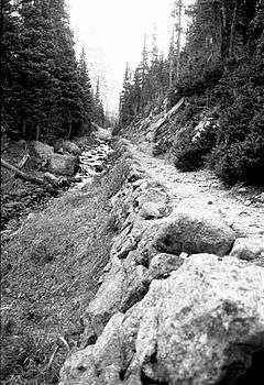
Fall River Road |
|
000000001987-07-20-0000July 20, 1987
(#87001129) |
Fall River Rd.
40°25′47″N 105°42′43″W / 40.429722°N 105.711944°W / 40.429722; -105.711944 (Fall River Road) |
Estes Park |
|
| 31 |
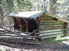
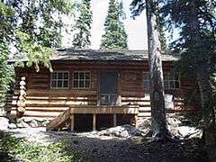
Fern Lake Patrol Cabin |
|
000000001988-01-29-0000January 29, 1988
(#87001142) |
Fern Lake
40°20′17″N 105°40′34″W / 40.338056°N 105.676111°W / 40.338056; -105.676111 (Fern Lake Patrol Cabin) |
Estes Park |
|
| 32 |
Fern Lake Trail |
|
000000002005-02-28-0000February 28, 2005
(#05000074) |
Rocky Mountain National Park
40°20′34″N 105°39′48″W / 40.342778°N 105.663333°W / 40.342778; -105.663333 (Fern Lake Trail) |
Estes Park |
|
| 33 |
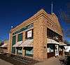
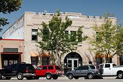
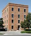
First National Bank Building |
|
000000002000-08-10-0000August 10, 2000
(#00000937) |
3728 Cleveland Ave.
40°42′15″N 105°00′20″W / 40.704167°N 105.005556°W / 40.704167; -105.005556 (First National Bank Building) |
Wellington |
|
| 34 |
First United Presbyterian Church |
|
000000002004-07-07-0000July 7, 2004
(#04000664) |
400 E. 4th St.
40°23′43″N 105°04′16″W / 40.395278°N 105.071111°W / 40.395278; -105.071111 (First United Presbyterian Church) |
Loveland |
|
| 35 |
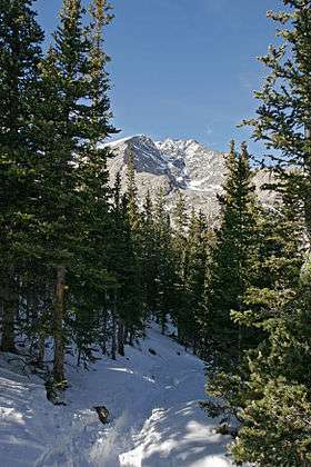
Flattop Mountain Trail |
|
000000002007-09-27-0000September 27, 2007
(#07000999) |
Rocky Mountain National Park[7]
40°18′50″N 105°40′42″W / 40.313889°N 105.678333°W / 40.313889; -105.678333 (Flattop Mountain Trail) |
Estes Park |
|
| 36 |
Jacob and Elizabeth Flowers House |
|
000000002007-03-01-0000March 1, 2007
(#07000086) |
5200 W. County Road 52E
40°37′48″N 105°10′19″W / 40.63°N 105.171944°W / 40.63; -105.171944 (Jacob and Elizabeth Flowers House) |
Bellvue |
|
| 37 |
Fort Collins Armory |
|
000000002002-10-15-0000October 15, 2002
(#02001133) |
314 E. Mountain Ave.
40°35′14″N 105°04′21″W / 40.587222°N 105.0725°W / 40.587222; -105.0725 (Fort Collins Armory) |
Fort Collins |
|
| 38 |
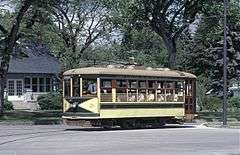
Fort Collins Municipal Railway Birney Safety Streetcar No. 21 |
|
000000001984-01-05-0000January 5, 1984
(#84000860) |
1801 W. Mountain Ave.
40°35′12″N 105°06′32″W / 40.586667°N 105.108889°W / 40.586667; -105.108889 (Fort Collins Municipal Railway Birney Safety Streetcar No. 21) |
Fort Collins |
|
| 39 |
Fort Collins Post Office |
|
000000001978-01-30-0000January 30, 1978
(#78000868) |
201 S. College Ave.
40°35′07″N 105°04′37″W / 40.585278°N 105.076944°W / 40.585278; -105.076944 (Fort Collins Post Office) |
Fort Collins |
Now used as the Ft. Collins Museum of Contemporary Art
|
| 40 |
Montezuma Fuller House |
|
000000001978-12-15-0000December 15, 1978
(#78000869) |
226 W. Magnolia St.
40°34′58″N 105°04′47″W / 40.582778°N 105.079722°W / 40.582778; -105.079722 (Montezuma Fuller House) |
Fort Collins |
|
| 41 |
Gem Lake Trail |
|
000000002008-01-29-0000January 29, 2008
(#07001473) |
North of Devils Gulch Rd. to Gem Lake[8]
40°24′40″N 105°30′13″W / 40.411111°N 105.503611°W / 40.411111; -105.503611 (Gem Lake Trail) |
Estes Park |
|
| 42 |
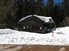
Glacier Basin Campground Ranger Station |
|
000000001987-07-20-0000July 20, 1987
(#87001143) |
Glacier Basin
40°19′48″N 105°35′40″W / 40.33°N 105.594444°W / 40.33; -105.594444 (Glacier Basin Campground Ranger Station) |
Estes Park |
|
| 43 |
Great Western Sugar Company Effluent Flume and Bridge |
|
000000002014-11-19-0000November 19, 2014
(#14000927) |
Cache la Poudre R., 1/2 mi. W. of Timberline Rd.
40°34′42″N 105°02′43″W / 40.5784°N 105.0453°W / 40.5784; -105.0453 (Great Western Sugar Company Effluent Flume and Bridge) |
Fort Collins |
|
| 44 |
Greeley, Salt Lake and Pacific Railroad-Stout Branch |
|
000000002008-04-16-0000April 16, 2008
(#08000291) |
Approximately 0.5 miles (0.80 km) south of the junction of U.S. Highway 287 and County Road 28
40°37′32″N 105°09′05″W / 40.625598°N 105.151416°W / 40.625598; -105.151416 (Greeley, Salt Lake and Pacific Railroad-Stout Branch) |
Laporte |
|
| 45 |
Harmony Mill |
|
000000001995-11-22-0000November 22, 1995
(#95001327) |
131 Lincoln Ave.
40°35′18″N 105°04′13″W / 40.588333°N 105.070278°W / 40.588333; -105.070278 (Harmony Mill) |
Fort Collins |
|
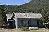
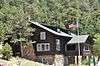
| 46 |
Hewes-Kirkwood Inn |
|
000000001994-10-28-0000October 28, 1994
(#94001254) |
465 Long Peak Rd.
40°16′18″N 105°33′15″W / 40.2717°N 105.5542°W / 40.2717; -105.5542 (Hewes-Kirkwood Inn) |
Estes Park |
Now part of an adult summer music camp.
|
| 47 |
Homestead Meadows Discontiguous District |
|
000000001990-10-04-0000October 4, 1990
(#90001476) |
At the end of Lion Gulch[9]
40°19′N 105°27′W / 40.31°N 105.45°W / 40.31; -105.45 (Homestead Meadows Discontiguous District) |
Estes Park |
|
| 48 |
Kaplan-Hoover Site |
Upload image |
000000002003-04-18-0000April 18, 2003
(#03000229) |
800 metres (2,600 ft) south of the Cache La Poudre River, west of Windsor[10]
40°28′19″N 104°57′20″W / 40.471944°N 104.955556°W / 40.471944; -104.955556 (Kaplan-Hoover Site) |
Windsor |
A bone bed 15 metres (49 ft) long, dating from the Late Archaic period[10]
|
| 49 |
Kissock Block Building |
|
000000001985-05-16-0000May 16, 1985
(#85001061) |
115-121 E. Mountain Ave.
40°35′12″N 105°04′33″W / 40.586667°N 105.075833°W / 40.586667; -105.075833 (Kissock Block Building) |
Fort Collins |
|
| 50 |
Lake Haiyaha Trail |
|
000000002008-03-05-0000March 5, 2008
(#08000125) |
Roughly along Bear, Nymph, and Dream Lakes, then up Chaos Canyon[11]
40°18′17″N 105°39′44″W / 40.304722°N 105.662222°W / 40.304722; -105.662222 (Lake Haiyaha Trail) |
Estes Park |
|
| 51 |
Laurel School Historic District |
Upload image |
000000001980-10-03-0000October 3, 1980
(#80000909) |
Off U.S. Highway 287
40°34′40″N 105°04′20″W / 40.577778°N 105.072222°W / 40.577778; -105.072222 (Laurel School Historic District) |
Fort Collins |
|
| 52 |
Leiffer House |
Upload image |
000000001978-08-02-0000August 2, 1978
(#78000278) |
South of Estes Park off State Highway 7
40°16′34″N 105°32′42″W / 40.276111°N 105.545°W / 40.276111; -105.545 (Leiffer House) |
Estes Park |
|
| 53 |
Lindenmeier Site |
|
000000001966-10-15-0000October 15, 1966
(#66000249) |
Address Restricted
|
Fort Collins |
|
| 54 |
Livermore Hotel and General Store |
|
000000002001-09-14-0000September 14, 2001
(#01000970) |
2140 Red Feather Lakes Road[12]
40°47′16″N 105°15′14″W / 40.78773°N 105.25393°W / 40.78773; -105.25393 (Livermore Hotel and General Store) |
Livermore |
|
| 55 |
Lost Lake Trail |
Upload image |
000000002008-03-05-0000March 5, 2008
(#08000126) |
Roughly along the North Fork of the Big Thompson River[13]
40°29′56″N 105°33′02″W / 40.498889°N 105.550556°W / 40.498889; -105.550556 (Lost Lake Trail) |
Estes Park |
|
| 56 |
Loveland State Armory |
|
000000002001-04-12-0000April 12, 2001
(#01000350) |
201 S. Lincoln Ave.
40°23′28″N 105°04′23″W / 40.391111°N 105.073056°W / 40.391111; -105.073056 (Loveland State Armory) |
Loveland |
|
| 57 |
R.G. Maxwell House |
|
000000001980-09-29-0000September 29, 1980
(#80000910) |
2340 W. Mulberry St.
40°35′44″N 105°08′24″W / 40.595556°N 105.14°W / 40.595556; -105.14 (R.G. Maxwell House) |
Fort Collins |
|
| 58 |
MacGregor Ranch |
|
000000001989-07-31-0000July 31, 1989
(#89001008) |
180 MacGregor Ave.
40°23′45″N 105°31′58″W / 40.395833°N 105.532778°W / 40.395833; -105.532778 (MacGregor Ranch) |
Estes Park |
|
| 59 |
William H. McCreery House |
|
000000002001-05-02-0000May 2, 2001
(#01000445) |
746 N. Washington Ave.
40°23′57″N 105°04′10″W / 40.399167°N 105.069444°W / 40.399167; -105.069444 (William H. McCreery House) |
Loveland |
|
| 60 |
McGraw Ranch |
|
000000001998-09-17-0000September 17, 1998
(#98001163) |
McGraw Ranch Rd.
40°25′53″N 105°30′06″W / 40.431389°N 105.501667°W / 40.431389; -105.501667 (McGraw Ranch) |
Estes Park |
|
| 61 |
McHugh-Andrews House |
|
000000001978-12-27-0000December 27, 1978
(#78000870) |
202 Remington St.
40°35′08″N 105°04′29″W / 40.585556°N 105.074722°W / 40.585556; -105.074722 (McHugh-Andrews House) |
Fort Collins |
|
| 62 |
Enos Mills Homestead Cabin |
|
000000001973-05-11-0000May 11, 1973
(#73000480) |
South of Estes Park off State Highway 7
40°16′54″N 105°32′24″W / 40.2817°N 105.54°W / 40.2817; -105.54 (Enos Mills Homestead Cabin) |
Estes Park |
|
| 63 |
Milner-Schwarz House |
|
000000002014-03-19-0000March 19, 2014
(#14000058) |
710 S. Railroad Ave.
40°23′09″N 105°04′52″W / 40.385798°N 105.081001°W / 40.385798; -105.081001 (Milner-Schwarz House) |
Loveland |
|
| 64 |
Moraine Lodge |
|
000000001976-10-08-0000October 8, 1976
(#76000206) |
West of Estes Park off U.S. Highway 36 on Bear Lake Rd.
40°21′31″N 105°34′59″W / 40.3586°N 105.5831°W / 40.3586; -105.5831 (Moraine Lodge) |
Estes Park |
Boundaries increased on 000000002005-06-15-0000June 15, 2005 under the name of "Moraine Park Museum and Amphitheater"
|
| 65 |
Mosman House |
|
000000001978-12-15-0000December 15, 1978
(#78000865) |
324 E. Oak St.
40°35′08″N 105°04′21″W / 40.585556°N 105.0725°W / 40.585556; -105.0725 (Mosman House) |
Fort Collins |
|
| 66 |
Mountainside Lodge |
|
000000002000-07-20-0000July 20, 2000
(#00000814) |
2515 Tunnel Rd.
40°20′05″N 105°35′20″W / 40.3347°N 105.5889°W / 40.3347; -105.5889 (Mountainside Lodge) |
Estes Park |
On the grounds of the YMCA of the Rockies
|
| 67 |
North Inlet Trail |
|
000000002008-03-05-0000March 5, 2008
(#08000127) |
Roughly along North Inlet and Hallett Creek to Flattop Mountain[14]
40°15′50″N 105°47′22″W / 40.263889°N 105.789444°W / 40.263889; -105.789444 (North Inlet Trail) |
Grand Lake |
Extends into Grand County
|
| 68 |
Old Town Fort Collins |
|
000000001978-08-02-0000August 2, 1978
(#78000871) |
Roughly bounded by College Ave. and Mountain, Pine, Willow, and Walnut Sts.
40°35′22″N 105°04′27″W / 40.589444°N 105.074167°W / 40.589444; -105.074167 (Old Town Fort Collins) |
Fort Collins |
|
| 69 |
Opera House Block/Central Block Building |
|
000000001985-02-08-0000February 8, 1985
(#85000214) |
117-131 N. College Ave.
40°35′15″N 105°04′37″W / 40.5875°N 105.076944°W / 40.5875; -105.076944 (Opera House Block/Central Block Building) |
Fort Collins |
|
| 70 |
Park Theatre |
|
000000001984-06-14-0000June 14, 1984
(#84000862) |
130 Moraine Ave.
40°22′35″N 105°31′22″W / 40.376389°N 105.522778°W / 40.376389; -105.522778 (Park Theatre) |
Estes Park |
|
| 71 |
Peep O Day Park |
Upload image |
000000002011-08-10-0000August 10, 2011
(#11000520) |
5445 Wild Ln.
40°24′36″N 105°09′17″W / 40.41°N 105.154722°W / 40.41; -105.154722 (Peep O Day Park) |
Loveland |
|
| 72 |
Pleasant Valley School |
Upload image |
000000002003-10-11-0000October 11, 2003
(#03001008) |
4032 N. County Road 25E
40°38′51″N 105°11′07″W / 40.6475°N 105.185278°W / 40.6475; -105.185278 (Pleasant Valley School) |
Bellvue |
|
| 73 |
Plummer School |
|
000000001999-04-29-0000April 29, 1999
(#99000485) |
2524 E. Vine Dr.
40°35′47″N 105°01′46″W / 40.596389°N 105.029444°W / 40.596389; -105.029444 (Plummer School) |
Fort Collins |
|
| 74 |
Preston Farm |
Upload image |
000000002001-05-10-0000May 10, 2001
(#01000489) |
4605 S. Ziegler Rd.
40°31′19″N 105°01′14″W / 40.521944°N 105.020556°W / 40.521944; -105.020556 (Preston Farm) |
Fort Collins |
|
| 75 |
Provost Homestead-Herring Farm Rural Historic Landscape |
|
000000002010-12-27-0000December 27, 2010
(#10001053) |
2405 North Overland Trail
40°37′20″N 105°08′33″W / 40.622222°N 105.1425°W / 40.622222; -105.1425 (Provost Homestead-Herring Farm Rural Historic Landscape) |
Laporte |
|
| 76 |
Rialto Theater |
|
000000001988-02-17-0000February 17, 1988
(#87002213) |
228-230 E. 4th Ave.
40°23′43″N 105°04′24″W / 40.395278°N 105.073333°W / 40.395278; -105.073333 (Rialto Theater) |
Loveland |
|
| 77 |
T.H. Robertson House |
|
000000001992-07-02-0000July 2, 1992
(#92000811) |
420 W. Mountain Ave.
40°35′15″N 105°04′59″W / 40.5875°N 105.083056°W / 40.5875; -105.083056 (T.H. Robertson House) |
Fort Collins |
|
| 78 |
Rocky Mountain National Park Administration Building |
|
000000002001-01-03-0000January 3, 2001
(#01000069) |
U.S. Highway 36
40°21′58″N 105°33′38″W / 40.366111°N 105.560556°W / 40.366111; -105.560556 (Rocky Mountain National Park Administration Building) |
Estes Park |
|
| 79 |
Rocky Mountain National Park Utility Area Historic District |
|
000000001982-03-18-0000March 18, 1982
(#82001717) |
Beaver Meadows Entrance Rd.
40°21′50″N 105°33′38″W / 40.363889°N 105.560556°W / 40.363889; -105.560556 (Rocky Mountain National Park Utility Area Historic District) |
Estes Park |
|
| 80 |
E.A. Schlichter House |
Upload image |
000000002016-11-22-0000November 22, 2016
(#16000784) |
1312 S. College Ave.
40°34′14″N 105°04′36″W / 40.570434°N 105.076762°W / 40.570434; -105.076762 (E.A. Schlichter House) |
Fort Collins |
|
| 81 |
Henry K. and Mary E. Shaffer House |
|
000000002007-01-09-0000January 9, 2007
(#06001219) |
1302 N. Grant Ave.
40°24′22″N 105°04′42″W / 40.406111°N 105.078333°W / 40.406111; -105.078333 (Henry K. and Mary E. Shaffer House) |
Loveland |
|
| 82 |
Snogo Snow Plow |
|
000000002006-10-04-0000October 4, 2006
(#06000934) |
Rocky Mountain National Park
40°21′51″N 105°33′34″W / 40.364167°N 105.559444°W / 40.364167; -105.559444 (Snogo Snow Plow) |
Estes Park |
|
| 83 |
Soloman Batterson Ranch |
Upload image |
000000002010-10-15-0000October 15, 2010
(#10000860) |
603 Mount Moriah Rd.
40°44′18″N 105°24′19″W / 40.738333°N 105.405278°W / 40.738333; -105.405278 (Soloman Batterson Ranch) |
Livermore |
|
| 84 |
Spruce Hall |
|
000000001977-01-09-0000January 9, 1977
(#77000381) |
Colorado State University campus
40°34′38″N 105°04′40″W / 40.577222°N 105.077778°W / 40.577222; -105.077778 (Spruce Hall) |
Fort Collins |
|
| 85 |
Stanley Hotel |
|
000000001977-05-26-0000May 26, 1977
(#77000380) |
333 Wonder View Ave.
40°23′00″N 105°31′02″W / 40.383333°N 105.517222°W / 40.383333; -105.517222 (Stanley Hotel) |
Estes Park |
|
| 86 |
Stanley Hotel District |
|
000000001985-06-20-0000June 20, 1985
(#85001256) |
333 Wonder View Ave.; also Fish Hatchery Rd. at the Fall River
40°23′00″N 105°31′06″W / 40.383333°N 105.518333°W / 40.383333; -105.518333 (Stanley Hotel District) |
Estes Park |
Fish Hatchery is the Stanley Power Plant, a boundary increase of 000000001998-04-14-0000April 14, 1998
|
| 87 |
Gustav and Annie Swanson Farm |
|
000000002005-10-05-0000October 5, 2005
(#05001116) |
1932 N. U.S. Highway 287
40°22′03″N 105°04′21″W / 40.3675°N 105.0725°W / 40.3675; -105.0725 (Gustav and Annie Swanson Farm) |
Berthoud |
|
| 88 |
Tonahutu Creek Trail |
|
000000002008-03-05-0000March 5, 2008
(#08000130) |
Roughly along Tonahutu Creek to Flattop Mountain[15]
40°19′10″N 105°46′32″W / 40.319444°N 105.775556°W / 40.319444; -105.775556 (Tonahutu Creek Trail) |
Grand Lake |
Extends into Grand County
|
| 89 |
Trail Ridge Road |
|
000000001984-11-14-0000November 14, 1984
(#84000242) |
Rocky Mountain National Park
40°21′30″N 105°45′47″W / 40.358333°N 105.763056°W / 40.358333; -105.763056 (Trail Ridge Road) |
Estes Park |
Extends into Grand County
|
| 90 |
Twin Sisters Lookout |
|
000000001992-12-24-0000December 24, 1992
(#92001670) |
On the Twin Sisters Peaks in Rocky Mountain National Park
40°17′21″N 105°31′03″W / 40.289167°N 105.5175°W / 40.289167; -105.5175 (Twin Sisters Lookout) |
Estes Park |
|
| 91 |
Agnes Vaille Shelter |
|
000000001992-12-24-0000December 24, 1992
(#92001669) |
Northwest of Longs Peak along the East Longs Peak Trail in Rocky Mountain National Park
40°15′38″N 105°37′13″W / 40.260556°N 105.620278°W / 40.260556; -105.620278 (Agnes Vaille Shelter) |
Estes Park |
|
| 92 |
Virginia Dale Stage Station |
|
000000001985-09-26-0000September 26, 1985
(#85002562) |
Off U.S. Highway 287
40°58′24″N 105°21′54″W / 40.973333°N 105.365°W / 40.973333; -105.365 (Virginia Dale Stage Station) |
Virginia Dale |
|
| 93 |
Ernest Waycott House |
|
000000001993-12-02-0000December 2, 1993
(#93001363) |
1501 W. Mountain Ave.
40°35′13″N 105°06′13″W / 40.586944°N 105.103611°W / 40.586944; -105.103611 (Ernest Waycott House) |
Fort Collins |
|
| 94 |
William Allen White Cabins |
|
000000001973-10-25-0000October 25, 1973
(#73001944) |
West of Estes Park of Moraine Park Visitor Center in Rocky Mountain National Park
40°21′22″N 105°34′55″W / 40.356111°N 105.581944°W / 40.356111; -105.581944 (William Allen White Cabins) |
Estes Park |
|
| 95 |
Beatrice Willard Alpine Tundra Research Plots |
|
000000002007-10-25-0000October 25, 2007
(#07001101) |
U.S. Highway 34 at Rock Cut and Forest Canyon
40°23′43″N 105°42′40″W / 40.3953°N 105.7111°W / 40.3953; -105.7111 (Beatrice Willard Alpine Tundra Research Plots) |
Estes Park |
|
| 96 |
Willow Park Patrol Cabin |
|
000000001987-07-20-0000July 20, 1987
(#87001144) |
Fall River Rd.
40°25′59″N 105°44′01″W / 40.433056°N 105.733611°W / 40.433056; -105.733611 (Willow Park Patrol Cabin) |
Estes Park |
|
| 97 |
Willow Park Stable |
|
000000001987-07-20-0000July 20, 1987
(#87001145) |
Fall River Pass
40°26′01″N 105°43′59″W / 40.433611°N 105.733056°W / 40.433611; -105.733056 (Willow Park Stable) |
Estes Park |
|
| 98 |
Wind Ridge |
|
000000002002-10-15-0000October 15, 2002
(#02001130) |
1397 Clara Dr.
40°23′41″N 105°30′36″W / 40.3947°N 105.51°W / 40.3947; -105.51 (Wind Ridge) |
Estes Park |
|
| 99 |
Ypsilon Lake Trail |
|
000000002008-03-05-0000March 5, 2008
(#08000131) |
Along a ridge between Chiquita Creek and the Roaring River
Coordinates missing |
Estes Park |
|
.JPG)