| [2] |
Name on the Register[3] |
Image |
Date listed[4] |
Location |
City or town |
Description |
|---|
| 1 |
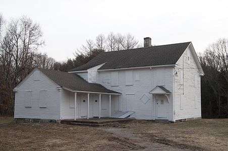
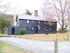
Allen-Madison House |
|
000000001980-03-28-0000March 28, 1980
(#80000015) |
Post Rd.
41°37′06″N 71°25′16″W / 41.618333°N 71.421111°W / 41.618333; -71.421111 (Allen-Madison House) |
North Kingstown |
|
| 2 |
David S. Baker Estate |
Upload image |
000000002011-08-04-0000August 4, 2011
(#11000512) |
51 & 67 Prospect Ave.
41°33′54″N 71°27′11″W / 41.565°N 71.453056°W / 41.565; -71.453056 (David S. Baker Estate) |
North Kingstown |
|
| 3 |
Camp Endicott |
|
000000001978-10-19-0000October 19, 1978
(#78000015) |
Between 7th and 10th Sts.
41°36′10″N 71°25′59″W / 41.602778°N 71.433056°W / 41.602778; -71.433056 (Camp Endicott) |
North Kingstown |
Mostly demolished; some Quonset huts survive at the Seabee Museum and Memorial Park
|
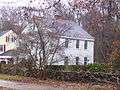
| 4 |
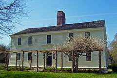
Silas Casey Farm |
|
000000001973-08-14-0000August 14, 1973
(#73000006) |
Boston Neck Rd.
41°30′40″N 71°26′01″W / 41.511111°N 71.433611°W / 41.511111; -71.433611 (Silas Casey Farm) |
North Kingstown |
|
| 5 |
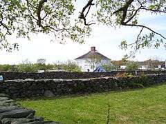
Cocumscossoc Archeological Site |
|
000000001993-04-12-0000April 12, 1993
(#93000605) |
55 Richard Smith Drive
41°35′00″N 71°27′16″W / 41.5833°N 71.4544°W / 41.5833; -71.4544 (Cocumscossoc Archeological Site) |
North Kingstown |
Area around one of state's oldest houses has yielded considerable information from digs
|
| 6 |
Crowfield Historic District |
Upload image |
000000001985-07-19-0000July 19, 1985
(#85001646) |
Boston Neck Rd.
41°32′00″N 71°25′27″W / 41.533333°N 71.424167°W / 41.533333; -71.424167 (Crowfield Historic District) |
North Kingstown |
|
| 7 |
Davisville Historic District |
|
000000001985-07-19-0000July 19, 1985
(#85001645) |
Davisville Rd.
41°37′17″N 71°28′52″W / 41.621389°N 71.481111°W / 41.621389; -71.481111 (Davisville Historic District) |
North Kingstown |
|
| 8 |
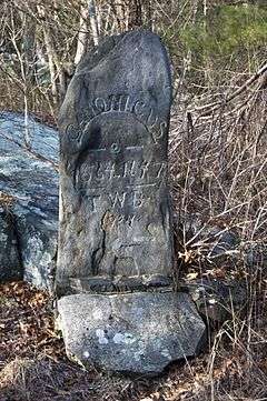
Devil's Foot Cemetery Archeological Site, RI-694 |
|
000000001984-11-15-0000November 15, 1984
(#84000562) |
Address Restricted
|
North Kingstown |
|
| 9 |
George Douglas House |
Upload image |
000000001975-10-10-0000October 10, 1975
(#75000006) |
South of Allenton at Tower Hill and Gilbert Stuart Rds.
41°31′18″N 71°27′46″W / 41.521667°N 71.462778°W / 41.521667; -71.462778 (George Douglas House) |
North Kingstown |
|
| 10 |
Ezekial Gardner House |
Upload image |
000000001985-07-19-0000July 19, 1985
(#85001654) |
297 Pendar Rd.
41°31′47″N 71°28′35″W / 41.529722°N 71.476389°W / 41.529722; -71.476389 (Ezekial Gardner House) |
North Kingstown |
|
| 11 |
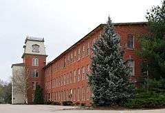
Hamilton Mill Village Historic District |
Upload image |
000000001983-11-03-0000November 3, 1983
(#83003874) |
Boston Neck and Martha Rds., Salisbury and Web Aves.
41°32′56″N 71°26′19″W / 41.548889°N 71.438611°W / 41.548889; -71.438611 (Hamilton Mill Village Historic District) |
North Kingstown |
|
| 12 |
Lafayette Village |
|
000000001978-11-14-0000November 14, 1978
(#78000019) |
Ten Rod Road
41°34′24″N 71°28′59″W / 41.573333°N 71.483056°W / 41.573333; -71.483056 (Lafayette Village) |
North Kingstown |
|
| 13 |
Stephen Northup House |
|
000000001985-07-19-0000July 19, 1985
(#85001653) |
99 Featherbed Lane
41°33′05″N 71°26′52″W / 41.551389°N 71.447778°W / 41.551389; -71.447778 (Stephen Northup House) |
North Kingstown |
Built by early Providence and Narragansett settler, Stephen Northup
|
| 14 |
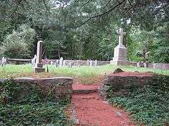
Old Narragansett Cemetery |
|
000000001985-07-19-0000July 19, 1985
(#85001655) |
Shermantown Rd.
41°31′08″N 71°28′42″W / 41.518889°N 71.478333°W / 41.518889; -71.478333 (Old Narragansett Cemetery) |
North Kingstown |
|
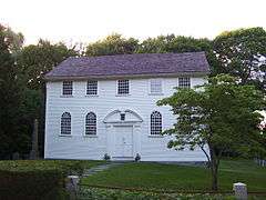
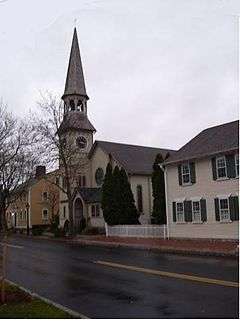
| 15 |
Old Narragansett Church |
|
000000001973-07-02-0000July 2, 1973
(#73000009) |
60 Church Lane, Wickford
41°34′21″N 71°26′59″W / 41.5725°N 71.449722°W / 41.5725; -71.449722 (Old Narragansett Church) |
North Kingstown |
|
| 16 |
Palmer-Northrup House |
|
000000001973-04-11-0000April 11, 1973
(#73000010) |
7919 Post Rd.
41°34′37″N 71°27′40″W / 41.576944°N 71.461111°W / 41.576944; -71.461111 (Palmer-Northrup House) |
North Kingstown |
|
| 17 |
Joseph Pierce Farm |
Upload image |
000000001985-07-19-0000July 19, 1985
(#85001652) |
933 Gilbert Stuart Rd.
41°31′22″N 71°26′42″W / 41.522778°N 71.445°W / 41.522778; -71.445 (Joseph Pierce Farm) |
North Kingstown |
|
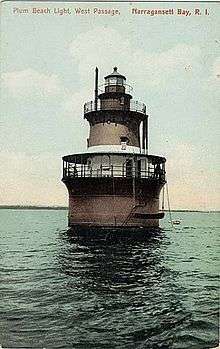
| 18 |
Plum Beach Lighthouse |
|
000000001988-03-30-0000March 30, 1988
(#88000281) |
Off Plum Beach, western passage of Narragansett Bay
41°31′48″N 71°24′20″W / 41.53°N 71.405556°W / 41.53; -71.405556 (Plum Beach Lighthouse) |
North Kingstown |
|
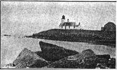
| 19 |
Poplar Point Lighthouse |
|
000000001988-02-25-0000February 25, 1988
(#87001703) |
1 Poplar Ave.
41°34′15″N 71°26′23″W / 41.570833°N 71.439722°W / 41.570833; -71.439722 (Poplar Point Lighthouse) |
North Kingstown |
|
| 20 |
Rathbun House |
Upload image |
000000001985-07-19-0000July 19, 1985
(#85001651) |
343 Beacon Dr.
41°34′20″N 71°30′20″W / 41.572222°N 71.505556°W / 41.572222; -71.505556 (Rathbun House) |
North Kingstown |
|
| 21 |
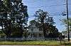
Benoni Ross House |
Upload image |
000000002008-12-28-0000December 28, 2008
(#08000717) |
97 Lafayette Road
41°34′24″N 71°29′24″W / 41.573333°N 71.49°W / 41.573333; -71.49 (Benoni Ross House) |
North Kingstown |
|
| 22 |
St. Paul's Church |
|
000000001972-06-30-0000June 30, 1972
(#72000009) |
76 Main St.
41°34′17″N 71°27′01″W / 41.571389°N 71.450278°W / 41.571389; -71.450278 (St. Paul's Church) |
North Kingstown |
|
| 23 |
Esbon Sanford House |
Upload image |
000000001985-07-19-0000July 19, 1985
(#85001649) |
88 Featherbed Lane
41°33′04″N 71°26′55″W / 41.551111°N 71.448611°W / 41.551111; -71.448611 (Esbon Sanford House) |
North Kingstown |
|
| 24 |
Saunderstown Historic District |
Upload image |
000000001985-07-19-0000July 19, 1985
(#85001647) |
Roughly bounded by Stillman, Waterway, Willet, Boston Neck & Ferry Rds.
41°30′28″N 71°25′21″W / 41.507778°N 71.4225°W / 41.507778; -71.4225 (Saunderstown Historic District) |
North Kingstown |
|
| 25 |
Scrabbletown Historic and Archeological District |
Upload image |
000000001985-04-11-0000April 11, 1985
(#85000790) |
Address Restricted
|
North Kingstown |
|
| 26 |
Shady Lea Historic District |
Upload image |
000000001985-07-19-0000July 19, 1985
(#85001644) |
Shady Lea and Tower Hill Rds.
41°32′07″N 71°27′56″W / 41.535278°N 71.465556°W / 41.535278; -71.465556 (Shady Lea Historic District) |
North Kingstown |
|
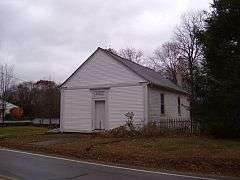
| 27 |
Six Principle Baptist Church |
|
000000001978-11-21-0000November 21, 1978
(#78000022) |
85 Old Baptist Rd.
41°35′34″N 71°29′29″W / 41.592778°N 71.491389°W / 41.592778; -71.491389 (Six Principle Baptist Church) |
North Kingstown |
|
| 28 |
Joseph Slocum House |
Upload image |
000000001985-07-19-0000July 19, 1985
(#85001648) |
Slocum Rd.
41°31′35″N 71°31′04″W / 41.526389°N 71.517778°W / 41.526389; -71.517778 (Joseph Slocum House) |
North Kingstown |
|
| 29 |
Spink Farm |
Upload image |
000000001985-07-19-0000July 19, 1985
(#85001650) |
1325 Shermantown Rd.
41°30′34″N 71°29′50″W / 41.509444°N 71.497222°W / 41.509444; -71.497222 (Spink Farm) |
North Kingstown |
|
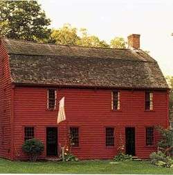
| 30 |
Gilbert Stuart Birthplace |
|
000000001966-10-15-0000October 15, 1966
(#66000004) |
Gilbert Stuart Rd.
41°31′36″N 71°26′44″W / 41.526667°N 71.445556°W / 41.526667; -71.445556 (Gilbert Stuart Birthplace) |
North Kingstown |
Birthplace of Gilbert Stuart, portraitist of George Washington and other Revolutionary figures. Preserved intact.
|
| 31 |
Wickford Historic District |
|
000000001974-12-31-0000December 31, 1974
(#74000013) |
Roughly bounded by Tower Hill and Post Rds. as far N as Mill Cove and S to Lindley Ave
41°34′12″N 71°27′24″W / 41.57°N 71.456667°W / 41.57; -71.456667 (Wickford Historic District) |
North Kingstown |
|
| 32 |
YWCA Site |
Upload image |
000000001980-11-20-0000November 20, 1980
(#80000027) |
Address Restricted
|
North Kingstown |
|

_(extra_close)_(US48).svg.png)