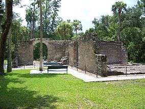
New Smyrna Sugar Mill Ruins
| New Smyrna Sugar Mill Ruins State Historic Site | |
|---|---|
|
IUCN category V (protected landscape/seascape) | |
 | |
| Location | Volusia County, Florida, United States |
| Nearest city | New Smyrna Beach, Florida |
| Coordinates | 29°00′32″N 80°56′28″W / 29.00889°N 80.94111°WCoordinates: 29°00′32″N 80°56′28″W / 29.00889°N 80.94111°W |
| Established | August 12, 1970 |
| Governing body | Florida Department of Environmental Protection |
| Wikimedia Commons has media related to New Smyrna Sugar Mill Ruins. |
The New Smyrna Sugar Mill Ruins (also known as the Cruger and DePeyster Sugar Mill) is a historic site in New Smyrna Beach, Florida, at 600 Old Mission Road. On August 12, 1970, it was added to the U.S. National Register of Historic Places.
In 1830 a steam sugar and saw mill were erected at this site. 5 years later the mills and other buildings were destroyed by Native Americans. The site was further altered by soldiers who were garrisoned there to keep an eye over the Seminoles
The ruins were listed on the National Register of Historic Places on August 12, 1970, reference number 70000192.[1]
References
- ↑ National Park Service (2010-07-09). "National Register Information System". National Register of Historic Places. National Park Service.
External links
- Volusia County listings at Florida's Office of Cultural and Historical Programs
- U.S. Territorial Period 1821-1845 at Volusia County History
- Images of the Black Seminole slave rebellion at John Horse and the Black Seminoles
- Historic American Buildings Survey (HABS) No. FL-15-4, "New Smyrna Sugar Mill (ruins), New Smyrna vicinity, Volusia County, FL", 5 photos, 4 measured drawings, 5 data pages, supplemental material
This article is issued from Wikipedia - version of the 11/19/2016. The text is available under the Creative Commons Attribution/Share Alike but additional terms may apply for the media files.

