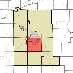
Perry Township, Monroe County, Indiana
| Perry Township | |
|---|---|
| Township | |
 Location in Monroe County | |
| Coordinates: 39°07′21″N 86°31′08″W / 39.12250°N 86.51889°WCoordinates: 39°07′21″N 86°31′08″W / 39.12250°N 86.51889°W | |
| Country |
|
| State |
|
| County | Monroe |
| Government | |
| • Type | Indiana township |
| Area | |
| • Total | 35.48 sq mi (91.9 km2) |
| • Land | 35.36 sq mi (91.6 km2) |
| • Water | 0.12 sq mi (0.3 km2) 0.34% |
| Elevation | 741 ft (226 m) |
| Population (2010) | |
| • Total | 50,673 |
| • Density | 1,433.2/sq mi (553.4/km2) |
| ZIP codes | 47401, 47403, 47404 |
| GNIS feature ID | 0453723 |
Perry Township is one of eleven townships in Monroe County, Indiana, United States. As of the 2010 census, its population was 50,673 and it contained 24,194 housing units.[1]
History
Perry Township was established in 1830.[2] It was named for Commodore Matthew C. Perry.[3]
Geography
According to the 2010 census, the township has a total area of 35.48 square miles (91.9 km2), of which 35.36 square miles (91.6 km2) (or 99.66%) is land and 0.12 square miles (0.31 km2) (or 0.34%) is water.[1]
Cities, towns, villages
- Bloomington (southern half of the city, south of [approximately] Third Street)
Unincorporated towns
- Broadview at 39°08′23″N 86°32′18″W / 39.13977°N 86.538330°W
- Clear Creek at 39°06′33″N 86°32′24″W / 39.109214°N 86.539997°W
- Handy at 39°05′45″N 86°29′38″W / 39.095881°N 86.493884°W
- Hoosier Acres at 39°09′28″N 86°29′13″W / 39.157825°N 86.48694°W
- Ridgemede at 39°09′07″N 86°30′11″W / 39.151992°N 86.503052°W
- Sanders at 39°04′47″N 86°30′48″W / 39.079770°N 86.513329°W
- Sunny Slopes at 39°07′55″N 86°31′52″W / 39.131992°N 86.531108°W
(This list is based on USGS data and may include former settlements.)
Cemeteries
The township contains Mount Salem Cemetery.
Major highways
School districts

In Perry Township (near Clear Creek Trail and That Road)
- Monroe County Community School Corporation
Political districts
- Indiana's 9th congressional district
- State House District 60
- State House District 61
- State Senate District 40
Gallery
 Kalacakra Stupa, Tibetan Mongolian Buddhist Cultural Center
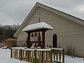 All Saints' Orthodox Church on a winter day
 A county road crossing Clear Creek
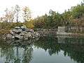 An old limestone quarry
References
- "Perry Township, Monroe County, Indiana". Geographic Names Information System. United States Geological Survey. Retrieved 2009-09-27.
- United States Census Bureau 2008 TIGER/Line Shapefiles
- IndianaMap
- 1 2 "Population, Housing Units, Area, and Density: 2010 - County -- County Subdivision and Place -- 2010 Census Summary File 1". United States Census. Retrieved 2013-05-10.
- ↑ Blanchard, Charles (1884). Counties of Morgan, Monroe and Brown, Indiana: Historical and Biographical. F.A. Battey & Company. p. 381.
- ↑ History of Lawrence and Monroe Counties, Indiana: Their People, Industries, and Institutions. B.F. Bowen. 1914. p. 417.
External links
- Indiana Township Association
- United Township Association of Indiana
- City-Data.com page for Perry Township
 |
Bloomington Township | Benton Township | | |
| Van Buren Township | |
Salt Creek Township | ||
| ||||
| | ||||
| Indian Creek Township | Clear Creek Township |
Municipalities and communities of Monroe County, Indiana, United States | ||
|---|---|---|
| City | ||
| Towns | ||
| Townships | ||
| CDPs | ||
| Other unincorporated communities |
| |
This article is issued from Wikipedia - version of the 11/3/2016. The text is available under the Creative Commons Attribution/Share Alike but additional terms may apply for the media files.