Pilar, Bataan
| Pilar | ||
|---|---|---|
| Municipality | ||
|
Municipal hall | ||
| ||
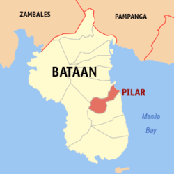 Location within Bataan province | ||
.svg.png) Pilar Location within the Philippines | ||
| Coordinates: 14°40′N 120°34′E / 14.67°N 120.57°ECoordinates: 14°40′N 120°34′E / 14.67°N 120.57°E | ||
| Country | Philippines | |
| Region | Central Luzon (Region III) | |
| Province | Bataan | |
| District | 2nd District of Bataan | |
| Founded | April 6, 1917 | |
| Barangays | 19 (see Barangays) | |
| Government [1] | ||
| • Type | Sangguniang Bayan | |
| • Mayor | Alice D. Pizarro (National Unity) | |
| • Vice Mayor | Marino Caguimbal (National Unity) | |
| Area[2] | ||
| • Total | 37.6 km2 (14.5 sq mi) | |
| Population (2015 census)[3] | ||
| • Total | 41,823 | |
| • Density | 1,100/km2 (2,900/sq mi) | |
| • Voter (2016)[4] | 26,876 | |
| Time zone | PST (UTC+8) | |
| ZIP code | 2102 | |
| IDD : area code | +63 (0)47 | |
| Income class | 3rd class | |
| PSGC | 030811000 | |
| Website |
www | |


Pilar, officially the Municipality of Pilar (Filipino: Bayan ng Pilar), is a municipality in the province of Bataan in the Central Luzon (Region III) of the Philippines. The population was 41,823 at the 2015 census.[3] In the 2016 election, it had 26,876 registered voters.[4]
The Bataan Government Center and the historic Mount Samat (Dambana ng Kagitingan) are both situated within the municipality in Barangays Diwa and Ala-uli, respectively.
Etymology and history
One of the oldest towns of Bataan, Pilar was previously part of Pampanga. Spaniards in the galleon landed in a sitio of Balanga and were greeted by the natives. The place was named in the honor of the image of the Our Lady of the Pillar, hence the town was called "Pilar".
Geography
Pilar is located at 14°40′N 120°34′E / 14.67°N 120.57°E.
According to the Philippine Statistics Authority, the municipality has a land area of 37.6 square kilometres (14.5 sq mi)[2] constituting 2.74% of the 1,372.98-square-kilometre- (530.11 sq mi) total area of Bataan.
Barangays
Pilar is politically subdivided into 19 barangays.[5]
| PSGC | Barangay | Population | ±% p.a. | ||
|---|---|---|---|---|---|
| 2015[3] | 2010[6] | ||||
| 030811001 | Ala‑uli | 10.7% | 4,458 | 3,895 | +2.60% |
| 030811003 | Bagumbayan | 3.4% | 1,427 | 1,370 | +0.78% |
| 030811005 | Balut I | 2.8% | 1,151 | 1,259 | −1.69% |
| 030811006 | Balut II | 3.0% | 1,260 | 1,311 | −0.75% |
| 030811007 | Bantan Munti | 1.1% | 467 | 550 | −3.07% |
| 030811009 | Burgos | 2.9% | 1,227 | 1,166 | +0.98% |
| 030811011 | Del Rosario (Poblacion) | 4.4% | 1,847 | 1,886 | −0.40% |
| 030811012 | Diwa | 6.0% | 2,491 | 2,253 | +1.93% |
| 030811013 | Landing | 3.1% | 1,311 | 1,246 | +0.97% |
| 030811014 | Liyang | 5.6% | 2,345 | 1,839 | +4.74% |
| 030811016 | Nagwaling | 7.2% | 3,006 | 2,568 | +3.04% |
| 030811019 | Panilao | 13.1% | 5,488 | 5,250 | +0.85% |
| 030811020 | Pantingan | 3.4% | 1,442 | 1,282 | +2.26% |
| 030811021 | Poblacion | 3.3% | 1,399 | 1,346 | +0.74% |
| 030811022 | Rizal (Poblacion) | 2.0% | 847 | 1,082 | −4.56% |
| 030811023 | Santa Rosa | 16.6% | 6,942 | 6,549 | +1.12% |
| 030811025 | Wakas North | 2.7% | 1,109 | 1,501 | −5.60% |
| 030811026 | Wakas South | 3.9% | 1,616 | 1,497 | +1.47% |
| 030811027 | Wawa | 4.8% | 1,990 | 1,937 | +0.52% |
| Total | 41,823 | 39,787 | +0.95% | ||
Demographics
| Population census of Pilar | |||||||||||||||||||||||||
|---|---|---|---|---|---|---|---|---|---|---|---|---|---|---|---|---|---|---|---|---|---|---|---|---|---|
|
| ||||||||||||||||||||||||
| Source: PSA[3][6][7] | |||||||||||||||||||||||||
In the 2015 census, Pilar had a population of 41,823.[3] The population density was 1,100 inhabitants per square kilometre (2,800/sq mi).
In the 2016 election, it had 26,876 registered voters.[4]
Government
Pursuant to the Local government in the Philippines",[8][9] the political seat of the municipal government is located at the Municipal Hall. In the History of the Philippines (1521–1898), the Gobernadorcillo was the Chief Executive who held office in the Presidencia. During the American rule (1898–1946) (History of the Philippines (1898-1946)), the elected Mayor and local officials, including the appointed ones held office at the Municipal Hall. The legislative and executive departments perform their functions in the Sangguniang Bayan (Session Hall) and Municipal Trial Court, respectively, and are located in the Town Hall.
Pilar, Bataan's elected officials are Mayor Alice D. Pizarro (National Unity) and Vice Mayor Marino Caguimbal (National Unity).
The eight Sangguniang Bayan Members led by the Vice-Mayor hold office at the Pilar Sangguniang Bayan Session Hall.
Attractions
Landmarks and festivals of Pilar include:
- Mount Samat Zipline — longest zipline in Luzon[10]
- Veterans Park — located in Poblacion, Piazza Della Virgen del Pilar
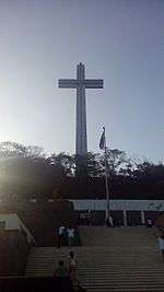
- Mount Samat National Shrine — 92-meter-high War Memorial Cross some 555 metres (1,821 ft) above sea level.[11]
- The Flaming Sword — located at Panilao, is a landmark depicting a hand holding a flaming sword up in the air, which symbolized the Filipino patriots' courage and gallantry as they face the adversary and threats to their democracy and freedom. The ESPADA was inaugurated on April 8, 1967.
- Dunsulan Falls
- Araw ng Kagitingan — celebrated every April 9
The 1801 Our Lady of the Pillar Parish Church (Nuestra Señora del Pilar Parish Church,[12] belongs to the Roman Catholic Diocese of Balanga[13][14][15] (Dioecesis Balangensis) Suffragan of San Fernando, Pampanga.[16]
Notable people from Pilar
- Mel Tiangco — Brgy. Santa Rosa - news Anchor of GMA7
- Manuel C. Herrera — lawyer, an instructor in the University of the Philippines
Gallery
-

Health center
-

The Flaming Sword Shrine
-

Port and bancas
-

Our Lady of the Pillar Parish Church
-

Light house
References
- ↑ "Municipality". Quezon City, Philippines: Department of the Interior and Local Government. Retrieved 31 May 2013.
- 1 2 "Province: Bataan". PSGC Interactive. Makati City, Philippines: Philippine Statistics Authority. Retrieved 22 November 2016.
- 1 2 3 4 5 "Region III (CENTRAL LUZON)". Census of Population (2015): Total Population by Province, City, Municipality and Barangay (Report). PSA. Retrieved 20 June 2016.
- 1 2 3 "2016 National and Local Elections Statistics". Commission on Elections. 2016.
- ↑ "Municipal: Pilar, Bataan". PSA. Philippines: National Statistical Coordination Board. Retrieved 8 January 2016.
- 1 2 "Region III (CENTRAL LUZON)". Census of Population and Housing (2010): Total Population by Province, City, Municipality and Barangay (Report). NSO. Retrieved 29 June 2016.
- ↑ "Region III (CENTRAL LUZON)". Census of Population (1995, 2000 and 2007): Total Population by Province, City and Municipality (Report). NSO. Archived from the original on 24 June 2011.
- ↑ "the 1987 Constitution of the Republic of the Philippines". Official Gazette of the Republic of the Philippines. Archived from the original on 22 January 2009. Retrieved 6 December 2016.
- ↑ "The Local Government Code Of The Philippines - Chan Robles Virtual Law Library". Chanrobles.com. Retrieved 2016-11-21.
- ↑ "Longest zipline sa Luzon, pinasinayaan sa Pilar, Bataan | Video | GMA News Online". Gmanetwork.com. 2012-01-09. Retrieved 2016-11-22.
- ↑ "WW2 historical markers remind Pinoys of Bataan's role on Day of Valor | Lifestyle | GMA News Online". Gmanetwork.com. Retrieved 2016-11-22.
- ↑ "Archived copy". Archived from the original on 2011-08-11. Retrieved 2013-01-30.
- ↑ "ParishesV1". Balangadiocese.com. Retrieved 2016-11-22.
- ↑ "Archived copy". Archived from the original on 2012-09-06. Retrieved 2013-01-27.
- ↑ "Archived copy". Archived from the original on 2014-05-17. Retrieved 2013-01-27.
- ↑ "Archived copy". Archived from the original on 2012-11-13. Retrieved 2013-01-30.
External links
| Wikimedia Commons has media related to Pilar, Bataan. |
- Pilar on MyBataan
 |
Balanga | | ||
| Bagac | |
Manila Bay | ||
| ||||
| | ||||
| Orion |
Balanga (capital) | |
| Municipalities | |
| Component city | |