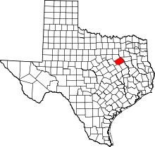
Retreat, Texas
| Retreat, Texas | |
|---|---|
| Town | |
|
Location of Retreat, Texas | |
 | |
| Coordinates: 32°3′4″N 96°28′28″W / 32.05111°N 96.47444°WCoordinates: 32°3′4″N 96°28′28″W / 32.05111°N 96.47444°W | |
| Country | United States |
| State | Texas |
| County | Navarro |
| Area | |
| • Total | 5.0 sq mi (12.9 km2) |
| • Land | 5.0 sq mi (12.9 km2) |
| • Water | 0.0 sq mi (0.0 km2) |
| Elevation | 472 ft (144 m) |
| Population (2000) | |
| • Total | 339 |
| • Density | 68.3/sq mi (26.4/km2) |
| Time zone | Central (CST) (UTC-6) |
| • Summer (DST) | CDT (UTC-5) |
| FIPS code | 48-61616[1] |
| GNIS feature ID | 1345120[2] |
| Historical population | |||
|---|---|---|---|
| Census | Pop. | %± | |
| 1970 | 263 | — | |
| 1980 | 255 | −3.0% | |
| 1990 | 334 | 31.0% | |
| 2000 | 339 | 1.5% | |
| 2010 | 377 | 11.2% | |
| Est. 2015 | 392 | [3] | 4.0% |
Retreat is a town in Navarro County, Texas, United States. The population was 339 at the 2000 census.
Geography
Retreat is located at 32°3′4″N 96°28′28″W / 32.05111°N 96.47444°W (32.051204, -96.474394).[5]
According to the United States Census Bureau, the town has a total area of 5.0 square miles (13 km2), of which, 5.0 square miles (13 km2) of it is land and 0.04 square miles (0.10 km2) of it (0.40%) is water.
History
Retreat is on Farm Road 709 just south of Corsicana in south central Navarro County. The site was settled in the 1840s and originally known as Beeman's School House. For many years the log school building, which was also used as a church, was the only church or school in the area. As a result of shifting population, the building was moved more than once. When someone consequently suggested calling the settlement Retreat, the name struck. A public school was in operation by 1900, and in 1906 it had an enrollment of fifty. In the mid-1930s Retreat had a store, a gin, a cemetery, and a number of houses. After World War II, the store closed, but the population in recent years has increased because of the community's proximity to Corsicana. In the mid-1960s the estimated population was 100; by 1990 it had grown to 334. Most of the residents worked in Corsicana.
Demographics
As of the census[1] of 2000, there were 339 people, 124 households, and 108 families residing in the town. The population density was 68.3 people per square mile (26.4/km²). There were 127 housing units at an average density of 25.6 per square mile (9.9/km²). The racial makeup of the town was 91.45% White, 4.72% African American, 2.65% Pacific Islander, 1.18% from other races. Hispanic or Latino of any race were 3.54% of the population.
There were 124 households out of which 33.9% had children under the age of 18 living with them, 75.8% were married couples living together, 5.6% had a female householder with no husband present, and 12.1% were non-families. 9.7% of all households were made up of individuals and 5.6% had someone living alone who was 65 years of age or older. The average household size was 2.73 and the average family size was 2.90.
In the town the population was spread out with 23.9% under the age of 18, 6.8% from 18 to 24, 26.8% from 25 to 44, 34.2% from 45 to 64, and 8.3% who were 65 years of age or older. The median age was 40 years. For every 100 females there were 103.0 males. For every 100 females age 18 and over, there were 106.4 males.
The median income for a household in the town was $49,688, and the median income for a family was $58,125. Males had a median income of $31,250 versus $25,625 for females. The per capita income for the town was $21,308. About 1.9% of families and 6.6% of the population were below the poverty line, including 10.3% of those under age 18 and 7.1% of those age 65 or over.
Education
The Town of Retreat is served by the Corsicana Independent School District.
Bibliography
- Annie Carpenter Love, History of Navarro County (Dallas: Southwestern, 1933)
- Wyvonne Putman, comp., Navarro County History (4 vols., Quanah, Texas: Nortex, 1975–84)
- Alva Taylor, History and Photographs of Corsicana and Navarro County (Corsicana, Texas, 1959; rev. ed., Navarro County History and Photographs, Corsicana, 1962)
References
- 1 2 "American FactFinder". United States Census Bureau. Retrieved 2008-01-31.
- ↑ "US Board on Geographic Names". United States Geological Survey. 2007-10-25. Retrieved 2008-01-31.
- ↑ "Annual Estimates of the Resident Population for Incorporated Places: April 1, 2010 to July 1, 2015". Retrieved July 2, 2016.
- ↑ "Census of Population and Housing". Census.gov. Retrieved June 4, 2015.
- ↑ "US Gazetteer files: 2010, 2000, and 1990". United States Census Bureau. 2011-02-12. Retrieved 2011-04-23.
