Rossdale, Edmonton
| Rossdale | |
|---|---|
| Neighbourhood | |
|
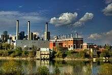
EPCOR's Rossdale Power Plant viewed from the High Level Bridge | |
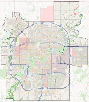
 Rossdale Location of Rossdale in Edmonton | |
| Coordinates: 53°31′55″N 113°29′46″W / 53.532°N 113.496°W | |
| Country |
|
| Province |
|
| City | Edmonton |
| Quadrant[1] | NW |
| Ward[1] | 6 |
| Sector[2] | Mature area |
| Area[3] | Central core |
| Government[4] | |
| • Mayor | Don Iveson |
| • Administrative body | Edmonton City Council |
| • Councillor | Scott McKeen |
| Area[5] | |
| • Total | 0.91 km2 (0.35 sq mi) |
| Elevation | 630 m (2,070 ft) |
| Population (2012)[6] | |
| • Total | 819 |
| • Density | 900/km2 (2,000/sq mi) |
| • Change (2009–12) |
|
| • Dwellings | 504 |
Rossdale is a river valley neighbourhood in the city of Edmonton, Alberta, Canada, located immediately south of the downtown core. It is a popular residential neighbourhood with easy access to downtown, the University of Alberta, the Edmonton river valley park system, and other amenities.
Edmonton Ballpark, home to the Edmonton Prospects baseball team of the Western Major Baseball League since 2012, is located in this neighbourhood. The Edmonton Trappers also called Edmonton Ballpark, then Telus Field, home up to the end of the 2004 season, when the franchise was moved to another city.
A short distance to the west of the neighbourhood, along River Valley Road, are the Victoria Golf Course, Victoria Park, and the Royal Glenora Club.
Archaeology and history
The site of the Rossdale powerplant was a First Nations campsite from the time that people first moved into the Edmonton area after the retreat of the glaciers around 8,000 years ago. In the early 1800s it was used as the site for the Hudson's Bay Company's Fort Edmonton and the North West Company's Fort Augustus, although this was only a theory until 2012 when a trench thought to be part of stockade wall was unearthed.[7]
Demographics
In the City of Edmonton's 2012 municipal census, Rossdale had a population of 819 living in 504 dwellings,[6] a -4.7% change from its 2009 population of 859.[8] With a land area of 0.91 km2 (0.35 sq mi),[5] it had a population density of 900 people/km2 in 2012.[6][5]
Residential development
While Rossdale is an older neighbourhood with residential development beginning during the early years of Edmonton's history, there has been a significant redevelopment of the area in more recent years.
According to the 2001 federal census, only one residence in ten (9.9%) in modern Rossdale was built before the end of World War II. Another one in five residences (17.6%) were built between 1946 and 1970 and one residence in ten (11.0%) were built during the 1970s. One in four residences (24.2%) were built during the 1980s and two out of five (37.4%) were built during the 1990s.[9]
The most common type of residence in Rossdale, according to the 2005 municipal census, is a mixture of rented apartments and apartment style condominiums. These account for half (51%) of all residences in the neighbourhood. Two out of three of these residences are in low-rise buildings with fewer than five stories while one in three are in high-rise buildings with five or more stories. Single-family dwellings account for one out of every three (35%) of all residences in the neighbourhood. Row houses account for one in ten residences (10%). Four percent of all residences are duplexes.[10] Three out of every five (62%) are owner-occupied while two out of five (38%) are rented.[11]
Rossdale Power Plant

Located next to Edmonton Ballpark is the Rossdale Power Plant, used by EPCOR to generate electricity. Recently, planned expansion of the generating station generated a fair amount of controversy when it was discovered part of the site was used as an aboriginal burial ground. Originally built by the Edmonton Electric Lighting and Power Company, the owner Alex Taylor, sold the company to the city of Edmonton in 1902. The plant was shut down by EPCOR in 2009.[12]
EPCOR also operates the Rossdale Water Treatment plant located next to the Rossdale Power Plant. The water treatment plant was constructed in 1903 and remains in operation.[13]
Population mobility
The population in Rossdale is highly mobile. According to the 2005 municipal census, one in five (21.5%) of all residents had moved within the previous twelve months. Another one in five (22.4%) had moved within the previous one to three years. Only two out of every five (42%) residents had lived at the same address for five years or longer.[14]
References
- 1 2 "City of Edmonton Wards & Standard Neighbourhoods" (PDF). City of Edmonton. Retrieved February 13, 2013.
- ↑ "Edmonton Developing and Planned Neighbourhoods, 2011" (PDF). City of Edmonton. Retrieved February 13, 2013.
- ↑ "The Way We Grow: Municipal Development Plan Bylaw 15100" (PDF). City of Edmonton. 2010-05-26. Retrieved February 13, 2013.
- ↑ "Mayor and City Council". City of Edmonton. Retrieved February 26, 2016.
- 1 2 3 "Neighbourhoods (data plus kml file)". City of Edmonton. Retrieved February 22, 2013.
- 1 2 3 "Municipal Census Results – Edmonton 2012 Census". City of Edmonton. Retrieved February 22, 2013.
- ↑ http://www.archaeologydaily.com/news/201208198535/Footprint-of-old-fur-trading-fort-found-in-Rossdale-Flats.html
- ↑ "2009 Municipal Census Results". City of Edmonton. Retrieved February 22, 2013.
- ↑ http://censusdocs.edmonton.ca/DD23/FEDERAL%202001/Neighbourhood/ROSSDALE.pdf
- ↑ Duplexes include triplexes and fourplexes.
- ↑ http://censusdocs.edmonton.ca/C05002/MUNICIPAL%202005/Neighbourhood/ROSSDALE.pdf
- ↑ A New Future for the Rossdale Power Plant
- ↑ EPCOR Water Treatment Plant
- ↑ http://censusdocs.edmonton.ca/C05022B/MUNICIPAL%202005/Neighbourhood/ROSSDALE.pdf
External links
| Wikimedia Commons has media related to Rossdale, Edmonton. |
