Syrian towns and villages depopulated in the Arab–Israeli conflict


Pre-1967 Syrian towns and villages on the Golan Heights
Before the Six-Day War and Yom Kippur War, the Golan Heights comprised 312 inhabited areas, including 2 towns, 163 villages, and 108 farms.[1] In 1966, the Syrian population of the Golan Heights was estimated at 147,613.[2] Israel seized about 70% of the Golan Heights in the closing stages of the Six-Day War.[3] Many of these residents fled during the fighting,[4] or were driven out by the Israeli army,[5][6] and some were evacuated by the Syrian army.[5] A cease-fire line was established and large parts of the region came under Israeli military control, including the town of Quneitra, about 139 villages and 61 farms.[1] Of these, the Census of Population 1967 conducted by the Israeli Defence Forces listed only eight, including Quneitra.[1] One of the remaining populated villages, Shayta, was partially destroyed in 1967 and a military post built in its place.[7] Between 1971–72 it was destroyed completely, with the remaining population forcibly transferred to Mas'ade, another of the populated villages under Israeli control.[7][8]
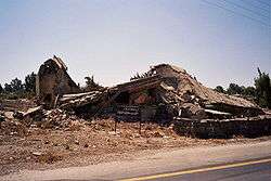
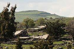
The Israeli Head of Surveying and Demolition Supervision for the Golan Heights proposed the demolition of 127 of the unpopulated villages, with about 90 abandoned villages to be demolished shortly after May 15, 1968.[9][10] The demolitions were carried out by contractors hired for the job.[6][10][11][12][13][14] After the demolitions, the lands were given to Israeli settlers.[15] There was an effort to preserve buildings of archaeological significance and buildings useful for the planned Jewish settlements.[10]
After the 1973 Yom Kippur War, parts of the occupied Golan Heights were returned to Syrian control, including Quneitra, which had changed hands several times during the war. According to a United Nations Special Committee, Israeli forces had deliberately destroyed the city before their 1974 withdrawal.[16]
Depopulated and demolished towns and villages
Depopulated villagesAlphabetical list; all parts of the name are treated equally, including the article (al-, as-, etc.), but the diacritics are disregarded (for example ‘A is treated like a plain A). Caution: some names appear twice in different orthographic variations, originating from different sources.
|
Depopulated farmsAlphabetical list; all parts of the name are treated equally, including the article (al-, as-, etc.), but the diacritics are disregarded (for example ‘A is treated like a plain A).
|
See also
- Ethnic cleansing
- List of Arab towns and villages depopulated during the 1948 Palestinian exodus
- List of villages depopulated during the Arab–Israeli conflict
- Population transfer
Footnotes
- 1 2 3 Davis, Uri (1983). "The Golan Heights under Israeli Occupation 1967–1981" (PDF).
- ↑ (PDF). Al Marsad, the Arab Center for Human Rights in the Golan Heights. January 2007 http://www2.ohchr.org/english/bodies/cerd/docs/ngos/almarsad.pdf. Missing or empty
|title=(help);|contribution=ignored (help) - 1 2 Murphy & Gannon 2008, p. 24
- ↑ BBC News, Regions and territories: The Golan Heights
- 1 2 "Destroyed Villages in the Golan Heights". Archived from the original on 2012-02-18.
- 1 2 CatchWord (1979). The Round table, Volume 69, Issues 273–276. Round Table Limited. p. 77.
- 1 2 Murphy, Ray; Gannon, Declan (2008). "Changing the Landscape: Israel's Gross Violations of International Law in the Occupied Syrian Golan". Yearbook of International Humanitarian Law. Cambridge University Press. 11: 147.
- ↑ Sakr Abu Fakhr, "Voices from the Golan", Journal of Palestine Studies, Vol. 29, No. 4 (Autumn, 2000), University of California Press, p. 7.
- ↑ Kimmerling, Baruch (2003). Politicide: Ariel Sharon's War Against the Palestinians. Verso. p. 28. ISBN 978-1-84467-532-6.
- 1 2 3 "The Fate of Abandoned Arab Villages, 1965–1969" by Aron Shai, History & Memory Volume 18, Number 2, Fall/Winter 2006, pp. 86–106. "As the pace of the surveys increased in the West Bank, widespread operations also began on the Golan Heights, which had been captured from Syria during the war (figure 7). Dan Urman, whose official title was Head of Surveying and Demolition Supervision for the Golan Heights, was in charge of this task. Urman submitted a list of 127 villages for demolition to his bosses. … The demolitions were executed by contractors hired for the job. Financial arrangements and coordination with the ILA and the army were recorded in detail. Davidson commissioned surveys and demolition supervision from the IASS [Israel Archaeological Survey Society]. Thus, for example, in a letter dated 15 May 1968, he wrote to Ze'ev Yavin: 'Further to our meeting, this is to inform you that within a few days we will start demolishing about 90 abandoned villages on the Golan Heights (see attached list)."
- ↑ Edgar S. Marshall (2002). Israel: Current Issues and Historical Background. Nova Science Publishers. p. 33. ISBN 1-59033-325-X.
- ↑ Dorothy Weitz Drummond (2004). Holy land, Whose Land?: Modern Dilemma, Ancient Roots. Fairhurst Press. p. 43. ISBN 0-9748233-2-5.
- ↑ Philip Louis Gabriel (1978). In the Ashes: The Story of Lebanon. Whitmore Pub Co. p. 121. ISBN 0-87426-046-9.
- ↑ (2001) Report of the Special Committee to Investigate Israeli Practices Affecting the Human Rights of the Palestinian People and Other Arabs of the Occupied Territories J. Destruction of built-up areas and looting of property: "Following the occupation of the territory in 1967, the occupation authorities destroyed 244 villages and built-up areas in the Golan and expelled their population, sparing only five villages (Majdal Shams, Buq'ata, ‘Ayn Qunyah, Mas'ade and al-Ghajar)."
- ↑ "The Golan Heights under Israeli Occupation 1967–1981" p.5. "The remainder of 131 agricultural villages and 61 individual farms were wiped of the face of the earth by the Israeli occupation authorities immediately following the Israeli victory in the 1967 war. They were razed to the ground and their lands handed over to exclusive Israeli-Jewish settlement."
- ↑ (1974) Report of the Special Committee to Investigate Israeli Practices Affecting the Human Rights of the Population of the Occupied Territories
- 1 2 3 4 5 6 7 8 9 10 11 12 13 14 15 16 17 18 19 20 21 22 23 24 25 26 27 28 29 30 31 32 33 34 35 36 37 38 39 40 41 42 43 44 45 46 47 48 49 50 51 52 53 54 55 56 57 58 59 60 61 62 63 64 65 66 67 68 69 70 71 72 73 74 75 76 77 78 79 80 81 82 83 84 85 86 87 88 89 90 91 92 93 94 95 96 97 98 99 100 101 102 103 104 105 106 107 108 109 110 111 112 113 114 115 116 Kipnis, Yigal (2013). The Golan Heights: Political History, Settlement and Geography since 1949. Routledge. pp. 240–246. ISBN 978-0-203-56869-9.
- 1 2 3 4 5 6 7 8 9 10 11 12 13 14 15 16 17 18 19 20 21 22 23 24 25 26 27 28 29 30 31 32 33 34 35 36 37 38 39 40 41 42 43 44 45 46 47 48 49 50 51 52 53 54 55 56 57 58 59 60 61 62 "The Occupied Golan Heights". Archived from the original on 2013-08-21. – Map showing destroyed Arab villages.
- 1 2 3 4 5 6 7 8 9 10 11 12 13 14 15 16 17 18 19 20 21 22 23 24 25 26 27 28 29 30 31 32 33 34 35 36 37 38 39 40 41 42 43 44 45 46 47 48 49 50 51 Murphy & Gannon 2008, p28 + p69
- 1 2 3 4 5 6 7 8 9 10 11 12 13 14 15 16 17 18 19 20 21 22 23 24 25 26 27 28 29 30 31 32 33 34 35 36 37 38 39 40 41 42 43 44 45 46 47 48 49 50 51 52 53 54 55 56 57 58 59 60 61 Golan Heights and vicinity: October 1994 – CIA map showing abandoned/dismantled Syrian villages.
- 1 2 3 4 5 6 7 8 9 10 11 12 13 14 15 16 17 18 19 20 21 22 23 24 25 26 27 28 29 30 Murphy & Gannon 2008, p28 + p70
- 1 2 3 4 5 6 7 8 9 10 11 12 13 14 15 16 17 18 19 20 21 22 23 24 25 26 27 28 29 30 31 32 33 34 35 36 37 38 39 40 41 42 43 44 45 46 47 48 Murphy & Gannon 2008, p28 + p68
- 1 2 3 4 5 6 7 8 9 10 11 12 13 14 15 16 17 18 19 20 21 22 23 24 25 26 27 28 29 30 31 Murphy & Gannon 2008, p28 + p67
- 1 2 South Lebanon and Vicinity 1976, CIA map.
- ↑ Murphy & Gannon 2008, p 48
- ↑ Yaqut al-Hamawi, cited in le Strange, 1890, p. 485
- ↑ U.S. Committee for Refugees and Immigrants
External links
- Golan Heights and Vicinity: October 1994 – CIA map of the Golan Heights, at the Library of Congress, showing abandoned/dismantled Syrian villages.
- South Lebanon and Vicinity 1976 – Map from the University of Texas at Austin, showing Syrian villages in the Golan Heights from pre-1967 sources.
- Southern Lebanon Border Area 1986 – Map from the University of Texas at Austin general libraries map collection, showing Syrian villages in the Golan Heights from pre-1967 sources.