Tân Bình District
| Tân Bình District Quận Tân Bình | |
|---|---|
| District | |
 Tân Bình District | |
| Coordinates: 10°47′39″N 106°39′16″E / 10.79417°N 106.65444°ECoordinates: 10°47′39″N 106°39′16″E / 10.79417°N 106.65444°E | |
| Country |
|
| Centrally governed city | Hồ Chí Minh City |
| Seat | 22 Lý Thường Kiệt |
| Wards | 15 phường |
| Government | |
| • People's Committee | Thái Thị Dư |
| Area | |
| • Total | 22.38 km2 (8.64 sq mi) |
| Population | |
| • Total | 430,160 |
| • Density | 19,000/km2 (50,000/sq mi) |
| Demographics | |
| • Main ethnic groups | Predominantly Việt |
| Time zone | ICT (UTC+07:00) |
| Website | tanbinh.hochiminhcity.gov.vn |
Tân Bình is an urban district of Hồ Chí Minh City, Vietnam. The City's international airport is situated in the district.[1] It consists of 15 wards, from Ward 1 to Ward 15. It occupies 22.38 km². In the 2004 census, 397,569 people were recorded as living there. 2005 figures estimate that the population fell to 394,281.
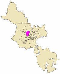
Location within Hồ Chí Minh City


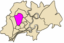
Tân Bình borders district 3, district 10, district 11, district 12, Tân Phú, Gò Vấp and Phú Nhuận. Tan Son Nhat International Airport is located in Tân Bình. Once the largest urban district of Hồ Chí Minh City, Tân Bình was partitioned to create Bình Tân District and Tân Phú District. Like Bình Thạnh, these three districts comprise a vast residential area which grew organically for more than 40 years without any urban planning.
Economy
Jetstar Pacific Airlines and Vietnam Air Service Company have their headquarters in the district.[2][3] VietJet Air has its Hồ Chí Minh City office in the district as well.[4]
Education
Tân Bình District has one of the most notable high schools in Hồ Chí Minh City, the Nguyễn Thượng Hiền High School. Other public high schools are Nguyễn Chí Thanh High School, Nguyễn Thái Bình High School and one of the most popular private high school in Ho Chi Minh city, Lý Tự Trọng High School.
Tân Bình School's Disability Workplace Education and Training Project is a collaborative project involving Tân Bình District Department of Education and Training, RMIT University's Department of Social and Community Services and the Loreto Vietnam Australia Program (LVAP). The project is funded by the Australian Government International Aid Program (AusAID) and technical support is provided by AVI (Australian Volunteers International).[5]
References
- ↑ "Tan Binh Map, Ho Chi Minh City". Vietnam Travel and Living Guide. Vietnam Online. Retrieved 2 June 2012.
- ↑ Archived October 3, 2009, at the Wayback Machine.
- ↑ VASCO. VASCO. Retrieved on 2013-07-16.
- ↑ Archived May 27, 2010, at the Wayback Machine.
- ↑ "Disability Workplace Education and Training Project". RMIT Vietnam. RMIT International University Vietnam. Retrieved 2 June 2012.
External links
- Quận Tân Bình Official site.
- Hue Street Food in Tân Bình District
- Things to Do in Tân Bình District, Ho Chi Minh

