Vardaman, Mississippi
| Vardaman, Mississippi | |
|---|---|
| Town | |
 | |
 Location of Vardaman, Mississippi | |
 Vardaman, Mississippi Location in the United States | |
| Coordinates: 33°52′47″N 89°10′37″W / 33.87972°N 89.17694°WCoordinates: 33°52′47″N 89°10′37″W / 33.87972°N 89.17694°W | |
| Country | United States |
| State | Mississippi |
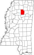
| County | Calhoun |
| Area | |
| • Total | 1.4 sq mi (3.5 km2) |
| • Land | 1.4 sq mi (3.5 km2) |
| • Water | 0.0 sq mi (0.0 km2) |
| Elevation | 289 ft (88 m) |
| Population (2010) | |
| • Total | 1,316 |
| • Density | 970/sq mi (374.4/km2) |
| Time zone | Central (CST) (UTC-6) |
| • Summer (DST) | CDT (UTC-5) |
| ZIP code | 38878 |
| Area code(s) | 662 |
| FIPS code | 28-76320 |
| GNIS feature ID | 0679189 |
Vardaman is a town in Calhoun County, Mississippi. The town's population was 1,316 at the time of the 2010 United States Census.[1]
Etymology
The town is named after James Kimble Vardaman, Mississippi governor from 1904 to 1908. Vardaman was a Democrat who later became a member of the United States Senate.
Geography
Vardaman is located in eastern Calhoun County. Mississippi Highway 8 passes through the town, leading west 8 miles (13 km) to Calhoun City and east 10 miles (16 km) to Houston.
According to the United States Census Bureau, the town has a total area of 1.4 square miles (3.5 km2), all land.[1] The Yalobusha River, a tributary of the Yazoo River, flows past the town less than one mile to the south.
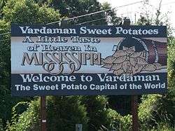
Vardaman is located in one of Mississippi's top five sweet potato-producing counties. The Vardaman Sweet Potato Festival, also known as the National Sweet Potato Festival, is held there annually the entire first week in November.[2][3] Vardaman has proclaimed itself the "Sweet Potato Capital of the World".[4]
Demographics
| Historical population | |||
|---|---|---|---|
| Census | Pop. | %± | |
| 1910 | 430 | — | |
| 1920 | 599 | 39.3% | |
| 1930 | 627 | 4.7% | |
| 1940 | 626 | −0.2% | |
| 1950 | 686 | 9.6% | |
| 1960 | 637 | −7.1% | |
| 1970 | 777 | 22.0% | |
| 1980 | 1,009 | 29.9% | |
| 1990 | 920 | −8.8% | |
| 2000 | 1,065 | 15.8% | |
| 2010 | 1,316 | 23.6% | |
| Est. 2015 | 1,297 | [5] | −1.4% |
As of the census[7] of 2000, there were 1,065 people, 426 households, and 276 families residing in the town. The population density was 785.3 people per square mile (302.4/km²). There were 471 housing units at an average density of 347.3 per square mile (133.7/km²). The racial makeup of the town was 58.69% White, 33.90% African American, 0.19% Native American, 0.09% Pacific Islander, 6.38% from other races, and 0.75% from two or more races. Hispanic or Latino of any race were 9.77% of the population.
There were 426 households out of which 31.2% had children under the age of 18 living with them, 42.3% were married couples living together, 18.3% had a female householder with no husband present, and 35.0% were non-families. 31.0% of all households were made up of individuals and 15.5% had someone living alone who was 65 years of age or older. The average household size was 2.50 and the average family size was 3.16.
In the town the population was spread out with 26.2% under the age of 18, 10.3% from 18 to 24, 27.0% from 25 to 44, 22.1% from 45 to 64, and 14.4% who were 65 years of age or older. The median age was 34 years. For every 100 females there were 86.8 males. For every 100 females age 18 and over, there were 84.1 males.
The median income for a household in the town was $21,518, and the median income for a family was $29,205. Males had a median income of $25,000 versus $17,750 for females. The per capita income for the town was $13,530. About 22.0% of families and 24.1% of the population were below the poverty line, including 25.8% of those under age 18 and 27.3% of those age 65 or over.
Education
Vardaman is served by the Calhoun County School District. Children in the Vardaman area attend either Vardaman Elementary School (Grades K-6) or Vardaman High School (Grades 7-12). Vardaman High School's sports teams are known as the Rams.
Notable people
Odie Armstrong, player in the Arena Football League
References
- 1 2 "Geographic Identifiers: 2010 Demographic Profile Data (G001): Vardaman town, Mississippi". U.S. Census Bureau, American Factfinder. Retrieved October 2, 2014.
- ↑ Vardaman Sweet Potato Festival
- ↑ Jaclyn Bethany, Sweet Potato Capital Of The World?, Jackson Free Press, March 18, 2009
- ↑ History.com
- ↑ "Annual Estimates of the Resident Population for Incorporated Places: April 1, 2010 to July 1, 2015". Retrieved July 2, 2016.
- ↑ "Census of Population and Housing". Census.gov. Retrieved June 4, 2015.
- ↑ "American FactFinder". United States Census Bureau. Retrieved 2008-01-31.
