Wibaux, Montana
| Wibaux, Montana | |
|---|---|
| Town | |
|
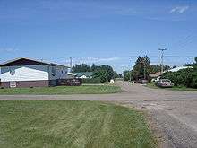
Main Street in Wibaux | |
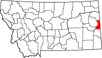
 Location of Wibaux, Montana | |
| Coordinates: 46°59′13″N 104°11′23″W / 46.98694°N 104.18972°WCoordinates: 46°59′13″N 104°11′23″W / 46.98694°N 104.18972°W | |
| Country | United States |
| State | Montana |
| County | Wibaux |
| Area[1] | |
| • Total | 1.08 sq mi (2.80 km2) |
| • Land | 1.08 sq mi (2.80 km2) |
| • Water | 0 sq mi (0 km2) |
| Elevation | 2,654 ft (809 m) |
| Population (2010)[2] | |
| • Total | 589 |
| • Estimate (2012[3]) | 616 |
| • Density | 545.4/sq mi (210.6/km2) |
| Time zone | Mountain (MST) (UTC-7) |
| • Summer (DST) | MDT (UTC-6) |
| ZIP code | 59353 |
| Area code(s) | 406 |
| FIPS code | 30-80350 |
| GNIS feature ID | 0778445 |
Wibaux (/ˈwiːboʊ/ WEE-boh) is a town in and the county seat of Wibaux County, Montana, United States.[4] The population was 589 at the 2010 census.[5]
Demographics
| Historical population | |||
|---|---|---|---|
| Census | Pop. | %± | |
| 1910 | 487 | — | |
| 1920 | 611 | 25.5% | |
| 1930 | 619 | 1.3% | |
| 1940 | 625 | 1.0% | |
| 1950 | 739 | 18.2% | |
| 1960 | 766 | 3.7% | |
| 1970 | 644 | −15.9% | |
| 1980 | 782 | 21.4% | |
| 1990 | 628 | −19.7% | |
| 2000 | 567 | −9.7% | |
| 2010 | 589 | 3.9% | |
| Est. 2015 | 666 | [6] | 13.1% |
| U.S. Decennial Census | |||
2010 census
As of the census[2] of 2010, there were 589 people, 278 households, and 153 families residing in the town. The population density was 545.4 inhabitants per square mile (210.6/km2). There were 308 housing units at an average density of 285.2 per square mile (110.1/km2). The racial makeup of the town was 96.4% White, 0.5% Native American, 0.7% Asian, 0.5% from other races, and 1.9% from two or more races. Hispanic or Latino of any race were 1.7% of the population.
There were 278 households of which 23.4% had children under the age of 18 living with them, 41.4% were married couples living together, 7.2% had a female householder with no husband present, 6.5% had a male householder with no wife present, and 45.0% were non-families. 42.4% of all households were made up of individuals and 17.3% had someone living alone who was 65 years of age or older. The average household size was 2.03 and the average family size was 2.76.
The median age in the town was 50.4 years. 19.5% of residents were under the age of 18; 4.3% were between the ages of 18 and 24; 19.3% were from 25 to 44; 31.7% were from 45 to 64; and 25.1% were 65 years of age or older. The gender makeup of the town was 47.4% male and 52.6% female.
2000 census
As of the census[7] of 2000, there were 567 people, 239 households, and 139 families residing in the town. The population density was 532.3 people per square mile (204.6/km²). There were 321 housing units at an average density of 301.4 per square mile (115.8/km²). The racial makeup of the town was 98.06% White, 0.35% African American, 0.53% Native American, 0.18% from other races, and 0.88% from two or more races. Hispanic or Latino of any race were 0.71% of the population.
There were 239 households out of which 25.1% had children under the age of 18 living with them, 46.9% were married couples living together, 8.8% had a female householder with no husband present, and 41.8% were non-families. 39.3% of all households were made up of individuals and 21.3% had someone living alone who was 65 years of age or older. The average household size was 2.22 and the average family size was 3.00.
In the town the population was spread out with 23.1% under the age of 18, 5.8% from 18 to 24, 21.2% from 25 to 44, 23.1% from 45 to 64, and 26.8% who were 65 years of age or older. The median age was 45 years. For every 100 females there were 80.6 males. For every 100 females age 18 and over, there were 78.0 males.
The median income for a household in the town was $26,518, and the median income for a family was $36,250. Males had a median income of $25,893 versus $20,250 for females. The per capita income for the town was $18,105. About 2.9% of families and 10.2% of the population were below the poverty line, including 1.7% of those under age 18 and 14.6% of those age 65 or over.
History

The town originally had names such as Keith, Beaver, and Mingusville (named for Minnie and Gus Grisy, who ran the Post Office in the late 19th century).[8] In 1895, the town was renamed for prominent local cattle rancher, Pierre Wibaux, who had immigrated to the area from France in 1883.[9] Wibaux expanded his herds by buying stock from less fortunate ranchers.[10]
After Wibaux's arrival, the town became a major cattle shipping center for the Northern Pacific Railroad,[9] notably receiving some of the cattle from Theodore Roosevelt's Maltese Cross and Elkhorn ranches near Medora, North Dakota.[11] The great cattle drives of the 1880s often passed by Wibaux on their way from Texas to the northern ranges.[12]
According to legend, Theodore Roosevelt got his nickname "Old Four Eyes" in Wibaux, (Mingusville, at the time) shortly after moving to the badlands from New York City. A drunk sheep rancher in the bar said "four eyes is buying". At first Roosevelt ignored him, but the man wouldn't let up. Eventually he walked over to confront Roosevelt. Roosevelt stood up, accidentally tripping the drunk man, who fell and did not get up. Roosevelt was praised as a hero, but immediately went and hid in his room, in case the sheepherder woke up and wanted to cause trouble.
Lore has it that in the late 1970s oil boom, Wibaux had a brawl unlike any seen before, straight out of an Old West show. Hundreds of drunk participants fought for hours in the streets. It started from some minor dispute.
Arleigh "Bunny" Meek, Jr. was the sheriff in Wibaux, and Wibaux County from 1968-1998 (32 years). He served longer than any other sheriff in Montana's history. He succeeded his father, Arleigh Meek, Sr. as sheriff. The only uniform he wore was his badge. Neither "Bunny" or his father carried a gun when they were sheriff, although they walked in and apprehended some very large, very violent (or drunk) individuals in this modern day old west town.
The National Register of Historical Places has three entries in Wibaux: The Pierre Wibaux House, St. Peter's Catholic Church, and the Wibaux Historical District.[13]
Modern day

Wibaux operates a state travel center at the town's exit from Interstate 94, the Pierre Wibaux House Museum, and the Centennial Car Museum, which was sent to the New York World's Fair in 1964. At the western end of town, there is a statue of Pierre Wibaux that he commissioned in his will to look over the sloping landscape.[8] Each year the town holds a summer festival, called the Ski Fest as homage to its predominantly Polish roots.[14] The 2002 Vin Diesel movie, Knockaround Guys, was based (although not filmed) in Wibaux.[15]
Geography and climate
Wibaux is located at 46°59′13″N 104°11′23″W / 46.98694°N 104.18972°W (46.986991, -104.189848).[16] It is the easternmost town in Montana along Interstate 94 and runs a rest stop/information center for motorists using the highway.[14] According to the United States Census Bureau, the town has a total area of 1.08 square miles (2.80 km2), all of it land.[1]
Beaver Creek runs through the town and has been known to contain large Walleye and Northern Pike.[14]
| Climate data for Wibaux, Montana (1981–2010) | |||||||||||||
|---|---|---|---|---|---|---|---|---|---|---|---|---|---|
| Month | Jan | Feb | Mar | Apr | May | Jun | Jul | Aug | Sep | Oct | Nov | Dec | Year |
| Average high °F (°C) | 27.6 (−2.4) |
32.4 (0.2) |
43.7 (6.5) |
57.0 (13.9) |
67.3 (19.6) |
76.7 (24.8) |
85.6 (29.8) |
85.2 (29.6) |
72.8 (22.7) |
57.5 (14.2) |
41.0 (5) |
28.7 (−1.8) |
56.3 (13.5) |
| Average low °F (°C) | 5.5 (−14.7) |
10.3 (−12.1) |
19.4 (−7) |
28.7 (−1.8) |
39.2 (4) |
47.9 (8.8) |
53.1 (11.7) |
52.0 (11.1) |
41.2 (5.1) |
30.0 (−1.1) |
18.2 (−7.7) |
7.0 (−13.9) |
29.4 (−1.4) |
| Average precipitation inches (mm) | 0.25 (6.4) |
0.25 (6.4) |
0.64 (16.3) |
1.34 (34) |
2.33 (59.2) |
2.77 (70.4) |
2.02 (51.3) |
1.38 (35.1) |
1.45 (36.8) |
1.25 (31.8) |
0.42 (10.7) |
0.24 (6.1) |
14.34 (364.2) |
| Average snowfall inches (cm) | 6.8 (17.3) |
6.0 (15.2) |
5.7 (14.5) |
4.8 (12.2) |
1.5 (3.8) |
0.0 (0) |
0.0 (0) |
0.0 (0) |
0.3 (0.8) |
2.4 (6.1) |
5.1 (13) |
5.6 (14.2) |
38.3 (97.3) |
| Source: NOAA[17] | |||||||||||||
References
- 1 2 "US Gazetteer files 2010". United States Census Bureau. Retrieved 2012-12-18.
- 1 2 "American FactFinder". United States Census Bureau. Retrieved 2012-12-18.
- ↑ "Population Estimates". United States Census Bureau. Retrieved 2013-06-03.
- ↑ "Find a County". National Association of Counties. Retrieved 2011-06-07.
- ↑ "2010 Census Redistricting Data (Public Law 94-171) Summary File". American FactFinder. United States Census Bureau. Retrieved 2 May 2011.
- ↑ "Annual Estimates of the Resident Population for Incorporated Places: April 1, 2010 to July 1, 2015". Retrieved July 2, 2016.
- ↑ "American FactFinder". United States Census Bureau. Retrieved 2008-01-31.
- 1 2 100 Most Influential Montanans of the Century, The Missoulan, The Missoulan
- 1 2 Pierre Wibaux, Ultimate Montana Atlas and Travel Encyclopedia
- ↑ Aarstad, Rich, Ellie Arguimbau, Ellen Baumler, Charlene Porsild, and Brian Shovers. Montana Place Names from Alzada to Zortman. Montana Historical Society Press.
- ↑ Theodore Roosevelt and the North Dakota Badlands,Roosevelt the RancherNational Park Service
- ↑ Theodore Roosevelt and the North Dakota Badlands, A Typical Cattle DriveNational Park Service
- ↑ Montana: Wibaux County, State Listings National Register of Historic Places
- 1 2 3 Wibaux, Montana, TravelMT.com, TravelMT.com, retrieved 5 August 2007
- ↑ Knockaround Guys, Reel.com
- ↑ "US Gazetteer files: 2010, 2000, and 1990". United States Census Bureau. 2011-02-12. Retrieved 2011-04-23.
- ↑ "NOWData - NOAA Online Weather Data". National Oceanic and Atmospheric Administration. Retrieved May 5, 2013.

