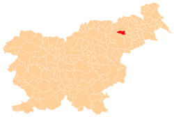
Čreta, Hoče–Slivnica
| Čreta | |
|---|---|
 Čreta Location in Slovenia | |
| Coordinates: 46°28′26.65″N 15°38′29.03″E / 46.4740694°N 15.6413972°ECoordinates: 46°28′26.65″N 15°38′29.03″E / 46.4740694°N 15.6413972°E | |
| Country |
|
| Traditional region | Styria |
| Statistical region | Drava |
| Municipality | Hoče–Slivnica |
| Area | |
| • Total | 3.52 km2 (1.36 sq mi) |
| Elevation | 300 m (1,000 ft) |
| Population (2002) | |
| • Total | 294 |
| [1] | |
Čreta (pronounced [ˈtʃɾeːta]) is a settlement in the Municipality of Hoče–Slivnica in northeastern Slovenia. It lies in the eastern foothills of the Pohorje Hills south of Maribor. The area is part of the traditional region of Styria. The municipality is now included in the Drava Statistical Region.[2]
An Iron Age and Roman-period hill fort with its associated burial ground with around 35 burial mounds have been identified near the settlement.[3]
References
External links
 Media related to Čreta, Hoče-Slivnica at Wikimedia Commons
- Čreta at Geopedia
This article is issued from Wikipedia - version of the 1/7/2016. The text is available under the Creative Commons Attribution/Share Alike but additional terms may apply for the media files.
