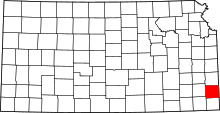
Chicopee, Kansas
| Chicopee, Kansas | |
|---|---|
| Census-designated place | |
 Chicopee Location within the state of Kansas | |
| Coordinates: 37°26′25″N 94°49′42″W / 37.44028°N 94.82833°WCoordinates: 37°26′25″N 94°49′42″W / 37.44028°N 94.82833°W | |
| Country | United States |
| State | Kansas |
| County | Crawford |
| Area | |
| • Total | 3.2 sq mi (8.3 km2) |
| • Land | 3.2 sq mi (8.2 km2) |
| • Water | 0.04 sq mi (0.1 km2) |
| Population (2010) | |
| • Total | 408 |
| • Density | 129/sq mi (49.8/km2) |
| Time zone | Central (CST) (UTC-6) |
| • Summer (DST) | CDT (UTC-5) |
Chicopee is a small unincorporated community and census-designated place in Crawford County, Kansas, United States. As of the 2010 census it had a population of 408.[1]
Geography
Chicopee lies at the intersection of the county roads known as South 200th Street & East 530th Avenue, 4 miles (6 km) by road southwest of downtown Pittsburg. The northwest corner of the town borders on the grounds of the Crestwood Country Club. The Crestwood golf course opened in 1958.[2]
History
- In 1905 Chicopee was described
Chicopee lies southwest of Pittsburg, and about the same distance as Frontenac on the northeast. Here is another mining village, of about one thousand population. The street cars from Pittsburg reach this town, and the Missouri Pacific and Santa Fe Railroads pass through this place. Several stores, a postoffice, boarding houses and other conveniences accommodate the people. Most of the inhabitants are of foreign birth, the Italian race predominating. The people are nearly all coal miners, and work for the several coal companies operating about Chicopee. They have good schools, which are well attended, and the children of these foreign born people are quick to get learning, and soon become excellent business men and women.
- In 1912 Chicopee was described
As one of the principal towns of Crawford county, is located in Baker township, 13 miles southeast of Girard, the county seat, and 4 miles southwest of Pittsburg. It is in the coal fields, and the chief occupation of the people is mining and shipping coal, the Atchison, Topeka & Santa Fe and the Missouri Pacific railroads (now abandoned before 2007) furnishing excellent transportation facilities. The town has a money order postoffice, telegraph and telephone facilities, Catholic and Protestant churches, good public schools, some well stocked stores, and in 1910 reported a population of 955.
The post office opened June 10, 1889, closed September 30, 1892, reopened October 8, 1892, and reclosed March 30, 1918.
Chicopee was the home of the defunct Idlehour amusement park.[3]
References
- ↑ "Geographic Identifiers: 2010 Demographic Profile Data (G001): Chicopee CDP, Kansas". U.S. Census Bureau, American Factfinder. Retrieved August 4, 2014.
- ↑ Crestwood Gold Course
- ↑ Defunct amusement park list Archived November 5, 2007, at the Wayback Machine.
- Page 330 from volume I of Kansas: a cyclopedia of state history, embracing events, institutions, industries, counties, cities, towns, prominent persons, etc. ... / with a supplementary volume devoted to selected personal history and reminiscence. Standard Pub. Co. Chicago : 1912. 3 v. in 4. : front., ill., ports.; 28 cm. Vols. I-II edited by Frank W. Blackmar. Transcribed May 2002 by Carolyn Ward.
- Pages 46-51 from A Twentieth century history and biographical record of Crawford County, Kansas, by Home Authors; Illustrated. Published by Lewis Publishing Company, Chicago, IL : 1905. 656 p. ill. Transcribed by Anthony Roberts and Chelsea Clark, students at Baxter Springs Middle School, Baxter Springs, Kansas, in September, 2002.

