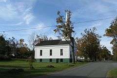
East Hawley Center Historic District
|
East Hawley Center Historic District | |
|
Congregational Church | |
  | |
| Location | Hawley, Massachusetts |
|---|---|
| Coordinates | 42°33′48″N 72°52′43″W / 42.56333°N 72.87861°WCoordinates: 42°33′48″N 72°52′43″W / 42.56333°N 72.87861°W |
| Built | 1810 |
| Architect | Unknown |
| Architectural style | Greek Revival, Italianate, Federal |
| NRHP Reference # | [1] |
| Added to NRHP | July 24, 1992 |
The East Hawley Center Historic District encompasses the principal institutional center of the town of Hawley, Massachusetts, with a history dating to the 1780s. Although it was settled in the late 18th century, issues with Hawley's boundaries meant that the development of a central village did not take place until later. East Hawley was developing as a local transportation hub by the mid 1820s, with several roads (mainly East Hawley Road, Plainfield Road, Ashfield Road, and Buckland Road, the latter three leading to eponymous neighboring towns) converging in the area. The establishment of a store and post office, and the relocation of the Congregational Church into the area cemented its importance in the town's civic life. There was some industrial mill activity in the area during the 19th century, but this came to an end near the end of the century, and only a mill pond remains.[2]
The district was listed on the National Register of Historic Places in 1992.[1]
See also
References
- 1 2 National Park Service (2008-04-15). "National Register Information System". National Register of Historic Places. National Park Service.
- ↑ "MACRIS inventory record for East Hawley Center Historic District". Commonwealth of Massachusetts. Retrieved 2013-12-20.

