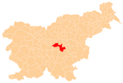
Gabrska Gora, Litija
| Gabrska Gora | |
|---|---|
 Gabrska Gora Location in Slovenia | |
| Coordinates: 45°59′12.67″N 14°57′44.29″E / 45.9868528°N 14.9623028°ECoordinates: 45°59′12.67″N 14°57′44.29″E / 45.9868528°N 14.9623028°E | |
| Country |
|
| Traditional region | Lower Carniola |
| Statistical region | Central Sava |
| Municipality | Litija |
| Area | |
| • Total | 2.2 km2 (0.8 sq mi) |
| Elevation | 420.1 m (1,378.3 ft) |
| Population (2002) | |
| • Total | 51 |
| [1] | |
Gabrska Gora (pronounced [ˈɡaːbəɾska ˈɡɔːɾa]) is a settlement south of Gabrovka in the Municipality of Litija in central Slovenia. Traditionally the area was part of Lower Carniola and is now included with the rest of the municipality in the Central Sava Statistical Region; until January 2014 the municipality was part of the Central Slovenia Statistical Region.[2] It includes the hamlets of Gora, Stari Boršt, Gabrje, and Turn (German: Gallenstein[3]).[4]
Castles
The ruins of two castles are found in Gabrska Gora. Turn Castle (German: Gallenstein) was owned by the Counts of Gallenberg. It was initially built as a fortified tower, and was later expanded and ornamented. It was inhabited until the Second World War, when it was owned by Marina Porca. Gabrja Castle (German: Gallenhoff) stood nearby and was also owned by the Gallenberg family.[4]
Church
The local church is dedicated to the Assumption of Mary and belongs to the Parish of Gabrovka. It dates to the 16th century and was restyled in the 18th century.[5]
References
- ↑ Statistical Office of the Republic of Slovenia
- ↑ Litija municipal site
- ↑ Leksikon občin kraljestev in dežel zastopanih v državnem zboru, vol. 6: Kranjsko. 1906. Vienna: C. Kr. Dvorna in Državna Tiskarna, p. 95.
- 1 2 Savnik, Roman, ed. 1971. Krajevni leksikon Slovenije, vol. 2. Ljubljana: Državna založba Slovenije, p. 262.
- ↑ Slovenian Ministry of Culture register of national heritage reference number ešd 2391
