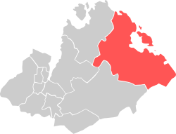
Høle
| Bydel Høle | ||
|---|---|---|
| Borough | ||
| ||
 Location within Sandnes municipality | ||
| Coordinates: 58°53′44″N 06°00′33″E / 58.89556°N 6.00917°ECoordinates: 58°53′44″N 06°00′33″E / 58.89556°N 6.00917°E | ||
| Country | Norway | |
| Region | Western Norway | |
| County | Rogaland | |
| District | Jæren | |
| City | Sandnes | |
| Area | ||
| • Total | 101.4 km2 (39.2 sq mi) | |
| Elevation[1] | 22 m (72 ft) | |
| Population (2016)[2] | ||
| • Total | 1,042 | |
| • Density | 10/km2 (27/sq mi) | |
| Time zone | CET (UTC+01:00) | |
| • Summer (DST) | CEST (UTC+02:00) | |
| Post Code | 4308 Sandnes | |
Høle is a borough and village in the western part of Sandnes municipality in Rogaland county, Norway. It is located along the Høgsfjorden in the eastern part of the municipality. The area was historically a part of the municipality of Høle. Høle Church and Høle School are both located in the village. The Norwegian National Road 13 runs through the village and the borough.
The 0.36-square-kilometre (89-acre) village has a population (2015) of 427, giving the village a population density of 1,186 inhabitants per square kilometre (3,070/sq mi).[3] The borough of Høle is the least populous (and most rural) borough in the city of Sandnes with 1,042 inhabitants.[2] The 101.4-square-kilometre (39.2 sq mi) borough is located in the eastern part of the municipality.
References
- ↑ "Høle, Sandnes (Rogaland)" (in Norwegian). yr.no. Retrieved 2016-03-29.
- 1 2 "Sandnes i tall" (in Norwegian). Sandnes Municipality. Retrieved 3 June 2011.
- ↑ Statistisk sentralbyrå (1 January 2015). "Urban settlements. Population and area, by municipality.".
