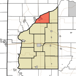
Logan Township, Fountain County, Indiana
| Logan Township | |
|---|---|
| Township | |
 Location of Logan Township in Fountain County | |
| Coordinates: 40°17′15″N 87°12′39″W / 40.28750°N 87.21083°WCoordinates: 40°17′15″N 87°12′39″W / 40.28750°N 87.21083°W | |
| Country | United States |
| State | Indiana |
| County | Fountain |
| Government | |
| • Type | Indiana township |
| Area | |
| • Total | 22.62 sq mi (58.6 km2) |
| • Land | 22.23 sq mi (57.6 km2) |
| • Water | 0.38 sq mi (1.0 km2) |
| Elevation[1] | 679 ft (207 m) |
| Population (2010) | |
| • Total | 3,672 |
| • Density | 165.2/sq mi (63.8/km2) |
| FIPS code | 18-44622[2] |
| GNIS feature ID | 453579 |
Logan Township is one of eleven townships in Fountain County, Indiana, United States. As of the 2010 census, its population was 3,672 and it contained 1,685 housing units.[3]
History
The Bethel Church and Graveyard was listed on the National Register of Historic Places in 1995.[4]
Geography
According to the 2010 census, the township has a total area of 22.62 square miles (58.6 km2), of which 22.23 square miles (57.6 km2) (or 98.28%) is land and 0.38 square miles (0.98 km2) (or 1.68%) is water.[3] It contains the town of Attica, which is near the banks of the Wabash River and which has a population of about 3,200 people.
U.S. Route 41,[5] Indiana State Road 28[6] and Indiana State Road 55[7] enter the township from Warren County, across the river to the west; at this point they all share the same route. In passing through Attica, U.S. 41 and State Road 55 go south, while State Road 28 continues east. A Norfolk Southern Railway line also crosses the river into the township; the line continues east-northeast near the river,[8] carrying about 45 freight trains each day.[9]

Cemeteries
The township contains five cemeteries. Riverside and Saint Francis of Xavier are on the south edge of Attica,[10][11] while Hatton is on the southeast side of town.[12] Ruppert lies further to the southeast outside of town,[13] and Clark is in the far northeast corner of the township.[14]
References
- ↑ "US Board on Geographic Names". United States Geological Survey. 2007-10-25. Retrieved 2008-01-31.
- ↑ "American FactFinder". United States Census Bureau. Retrieved 2008-01-31.
- 1 2 "Population, Housing Units, Area, and Density: 2010 - County -- County Subdivision and Place -- 2010 Census Summary File 1". United States Census. Retrieved 2013-05-10.
- ↑ National Park Service (2010-07-09). "National Register Information System". National Register of Historic Places. National Park Service.
- ↑ "U.S. Route 41". Highway Explorer. Retrieved 2010-09-21.
- ↑ "State Road 28". Highway Explorer. Retrieved 2010-09-21.
- ↑ "State Road 55". Highway Explorer. Retrieved 2010-09-21.
- ↑ "State of Indiana 2011 Rail System Map" (PDF). Indiana Department of Transportation. 2011. Retrieved 2011-06-19.
- ↑ Warren County Local Economic Development Organization. "Warren County Transportation/Utilities". Retrieved 2010-09-12.
- ↑ "Riverside Cemetery". Geographic Names Information System. United States Geological Survey. Retrieved 2011-09-05.
- ↑ "Saint Francis of Xavier Cemetery". Geographic Names Information System. United States Geological Survey. Retrieved 2011-09-05.
- ↑ "Hatton Cemetery". Geographic Names Information System. United States Geological Survey. Retrieved 2011-09-05.
- ↑ "Ruppert Cemetery". Geographic Names Information System. United States Geological Survey. Retrieved 2011-09-05.
- ↑ "Clark Cemetery". Geographic Names Information System. United States Geological Survey. Retrieved 2011-09-05.
- "Logan Township, Fountain County, Indiana". Geographic Names Information System. United States Geological Survey. Retrieved 2009-09-24.
- United States Census Bureau cartographic boundary files
External links
 |
Warren Township, Warren County |  | ||
| Washington Township, Warren County | |
Davis Township | ||
| ||||
| | ||||
| Shawnee Township | |
Richland Township |