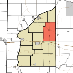
Richland Township, Fountain County, Indiana
| Richland Township | |
|---|---|
| Township | |
 Location of Richland Township in Fountain County | |
| Coordinates: 40°12′06″N 87°08′41″W / 40.20167°N 87.14472°WCoordinates: 40°12′06″N 87°08′41″W / 40.20167°N 87.14472°W | |
| Country | United States |
| State | Indiana |
| County | Fountain |
| Government | |
| • Type | Indiana township |
| Area | |
| • Total | 51.94 sq mi (134.5 km2) |
| • Land | 51.94 sq mi (134.5 km2) |
| • Water | 0 sq mi (0 km2) |
| Elevation | 722 ft (220 m) |
| Population (2010) | |
| • Total | 950 |
| • Density | 18.3/sq mi (7.1/km2) |
| FIPS code | 18-64026 |
| GNIS feature ID | 453791 |
Richland Township is one of eleven townships in Fountain County, Indiana, United States. As of the 2010 census, its population was 950 and it contained 423 housing units.[1]
Geography
According to the 2010 census, the township has a total area of 51.94 square miles (134.5 km2), all land.[1] It contains two incorporated towns: Newtown, with a population of about 250, lies near the center of the township; Mellott, with about 200 people, is about 2 miles (3.2 km) south. Indiana State Road 341 passes through both towns;[2] Indiana State Road 55 intersects State Road 341 in Newtown.[3] The two unincorporated communities of Graham and Stephens Crossing both lie to the southwest of Newtown along the route of a former railroad which came out of Veedersburg and also passed through Mellott and continued east.

Cemeteries
The township contains these seven cemeteries: Greenbay,[4] Hodson,[5] Newtown,[6] Oak Ridge,[7] Old Baptist,[8] Quirk[9] and Short.[10]
References
- 1 2 "Population, Housing Units, Area, and Density: 2010 - County -- County Subdivision and Place -- 2010 Census Summary File 1". United States Census. Retrieved 2013-05-10.
- ↑ "State Road 341". Highway Explorer. Retrieved 2010-09-21.
- ↑ "State Road 55". Highway Explorer. Retrieved 2010-09-21.
- ↑ "Greenbay Cemetery". Geographic Names Information System. United States Geological Survey. Retrieved 2011-09-10.
- ↑ "Hodson Cemetery". Geographic Names Information System. United States Geological Survey. Retrieved 2011-09-10.
- ↑ "Newtown Cemetery". Geographic Names Information System. United States Geological Survey. Retrieved 2011-09-10.
- ↑ "Oak Ridge Cemetery". Geographic Names Information System. United States Geological Survey. Retrieved 2011-09-10.
- ↑ "Old Baptist Cemetery". Geographic Names Information System. United States Geological Survey. Retrieved 2011-09-10.
- ↑ "Quirk Cemetery". Geographic Names Information System. United States Geological Survey. Retrieved 2011-09-10.
- ↑ "Short Cemetery". Geographic Names Information System. United States Geological Survey. Retrieved 2011-09-10.
