National Register of Historic Places listings in Alleghany County, Virginia

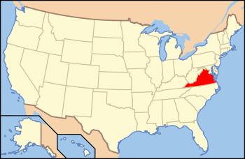
Location of Alleghany County in Virginia
This is a list of the National Register of Historic Places listings in Alleghany County, Virginia.
This is intended to be a complete list of the properties and districts on the National Register of Historic Places in Alleghany County, Virginia, United States. The locations of National Register properties and districts for which the latitude and longitude coordinates are included below, may be seen in a Google map.[1]
There are 14 properties and districts listed on the National Register in the county, including 1 National Historic Landmark.
- This National Park Service list is complete through NPS recent listings posted December 2, 2016.[2]
Current listings
| [3] |
Name on the Register[4] |
Image |
Date listed[5] |
Location |
City or town |
Description |
|---|
| 1 |
Clifton Forge Commercial Historic District |
|
000000001992-01-28-0000January 28, 1992
(#91002015) |
Roughly, E. Ridgeway St. from Roxbury St. to Main St. and Main from Commercial Ave. to Railroad St.
37°48′58″N 79°49′31″W / 37.816111°N 79.825278°W / 37.816111; -79.825278 (Clifton Forge Commercial Historic District) |
Clifton Forge |
|
| 2 |
Clifton Forge Residential Historic District |
|
000000002012-08-14-0000August 14, 2012
(#12000517) |
Roughly bounded by Memorial Park, Crown Hill Cemetery, Dry Creek, Keswick, Lowell, Main & Pine Sts., McCormick Blvd.
37°49′06″N 79°49′32″W / 37.818328°N 79.825591°W / 37.818328; -79.825591 (Clifton Forge Residential Historic District) |
Clifton Forge |
|
| 3 |
Clifton Furnace |
Upload image |
000000001977-08-16-0000August 16, 1977
(#77001485) |
Southeast of Clifton Forge off U.S. 220
37°48′34″N 79°47′50″W / 37.809444°N 79.797222°W / 37.809444; -79.797222 (Clifton Furnace) |
Clifton Forge |
|
| 4 |
Douthat State Park Historic District |
|
000000001986-09-20-0000September 20, 1986
(#86002183) |
VA 629
37°53′13″N 79°48′36″W / 37.886944°N 79.81°W / 37.886944; -79.81 (Douthat State Park Historic District) |
Millboro |
|
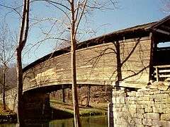
| 5 |
Humpback Bridge |
|
000000001969-10-01-0000October 1, 1969
(#69000219) |
Over Dunlap Creek, southwest of junction of U.S. Route 60 and State Route 651
37°48′02″N 80°02′49″W / 37.800556°N 80.046944°W / 37.800556; -80.046944 (Humpback Bridge) |
Callaghan |
National Historic Landmark designation October 16, 2012
|
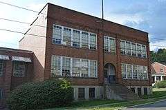
| 6 |
Jefferson School |
|
000000002010-12-27-0000December 27, 2010
(#10001061) |
A Street
37°48′57″N 79°49′08″W / 37.815833°N 79.818889°W / 37.815833; -79.818889 (Jefferson School) |
Clifton Forge |
|
| 7 |
Longdale Furnace Historic District |
Upload image |
000000001995-08-03-0000August 3, 1995
(#95000898) |
Roughly, along Longdale Furnace Rd., Iron Ore Ln., Church Rd. and Conner Ln.
37°48′33″N 79°41′04″W / 37.809167°N 79.684444°W / 37.809167; -79.684444 (Longdale Furnace Historic District) |
Clifton Forge |
|
| 8 |
Luke Mountain Historic District |
Upload image |
000000001998-06-26-0000June 26, 1998
(#98000737) |
Luke Mountain Rd.
37°47′36″N 80°00′18″W / 37.793333°N 80.005°W / 37.793333; -80.005 (Luke Mountain Historic District) |
Covington |
|
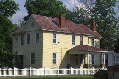
| 9 |
Massie House |
Upload image |
000000001982-07-08-0000July 8, 1982
(#82004669) |
US 220
37°52′41″N 79°55′15″W / 37.878056°N 79.920833°W / 37.878056; -79.920833 (Massie House) |
Falling Spring |
|
| 10 |
Oakland Grove Presbyterian Church |
|
000000001982-07-08-0000July 8, 1982
(#82004670) |
VA 696
37°48′07″N 79°51′37″W / 37.801944°N 79.860278°W / 37.801944; -79.860278 (Oakland Grove Presbyterian Church) |
Selma |
|
| 11 |
Persinger House |
Upload image |
000000001982-07-08-0000July 8, 1982
(#82004668) |
VA 788
37°43′04″N 80°03′34″W / 37.717778°N 80.059444°W / 37.717778; -80.059444 (Persinger House) |
Covington |
|
| 12 |
Rosedale Historic District |
|
000000001998-06-26-0000June 26, 1998
(#98000738) |
Roughly bounded by US 60, Jackson River. and Luke's Mountain
37°47′40″N 79°59′59″W / 37.794444°N 79.999722°W / 37.794444; -79.999722 (Rosedale Historic District) |
Covington |
|
| 13 |
Sweet Chalybeate Springs |
|
000000001974-01-21-0000January 21, 1974
(#74002103) |
South of Earlhurst on VA 311
37°38′38″N 80°14′32″W / 37.643889°N 80.242222°W / 37.643889; -80.242222 (Sweet Chalybeate Springs) |
Sweet Chalybeate |
|
| 14 |
Wood Hall |
Upload image |
000000001982-07-26-0000July 26, 1982
(#82004667) |
SR 600
37°48′58″N 80°04′21″W / 37.816111°N 80.0725°W / 37.816111; -80.0725 (Wood Hall) |
Callaghan |
|
See also
References
- ↑ The latitude and longitude information provided in this table was derived originally from the National Register Information System, which has been found to be fairly accurate for about 99% of listings. For about 1% of NRIS original coordinates, experience has shown that one or both coordinates are typos or otherwise extremely far off; some corrections may have been made. A more subtle problem causes many locations to be off by up to 150 yards, depending on location in the country: most NRIS coordinates were derived from tracing out latitude and longitudes off of USGS topographical quadrant maps created under the North American Datum of 1927, which differs from the current, highly accurate WGS84 GPS system used by most on-line maps. Chicago is about right, but NRIS longitudes in Washington are higher by about 4.5 seconds, and are lower by about 2.0 seconds in Maine. Latitudes differ by about 1.0 second in Florida. Some locations in this table may have been corrected to current GPS standards.
- ↑ "National Register of Historic Places: Weekly List Actions". National Park Service, United States Department of the Interior. Retrieved on December 2, 2016.
- ↑ Numbers represent an ordering by significant words. Various colorings, defined here, differentiate National Historic Landmarks and historic districts from other NRHP buildings, structures, sites or objects.
- ↑ National Park Service (2008-04-24). "National Register Information System". National Register of Historic Places. National Park Service.
- ↑ The eight-digit number below each date is the number assigned to each location in the National Register Information System database, which can be viewed by clicking the number.
|
|---|
|
Lists
by county | | |
|---|
|
Lists
by city | |
|---|
|
| Other lists | |
|---|
|
|

.jpg)
.jpg)

.jpg)