| [3] |
Name on the Register[4] |
Image |
Date listed[5] |
Location |
Description |
|---|
| 1 |
Boldrup Plantation Archeological Site |
Upload image |
000000001982-09-16-0000September 16, 1982
(#82004573) |
Address Restricted
|
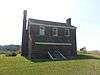
|
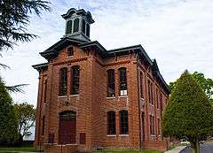
| 2 |
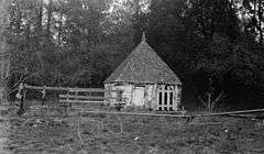
Causey's Mill |
|
000000002008-02-21-0000February 21, 2008
(#08000078) |
11700 Warwick Rd.
37°03′31″N 76°29′01″W / 37.058611°N 76.483611°W / 37.058611; -76.483611 (Causey's Mill) |
|
| 3 |
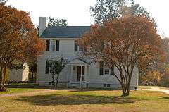
Simon Reid Curtis House |
|
000000002009-08-20-0000August 20, 2009
(#09000641) |
10 Elmhurst St.
37°11′37″N 76°34′23″W / 37.193589°N 76.572942°W / 37.193589; -76.572942 (Simon Reid Curtis House) |
|
| 4 |
Dam No. One Battlefield Site |
|
000000001995-08-04-0000August 4, 1995
(#95000972) |
13560 Jefferson Ave.
37°10′59″N 76°32′17″W / 37.183056°N 76.538056°W / 37.183056; -76.538056 (Dam No. One Battlefield Site) |
|
| 5 |
Denbigh Plantation Site |
|
000000001970-02-16-0000February 16, 1970
(#70000873) |
Route 60, Newport News
Coordinates missing |
|
| 6 |
Endview Plantation |
|
000000002008-05-08-0000May 8, 2008
(#08000391) |
362 Yorktown Rd.
37°12′12″N 76°34′30″W / 37.203297°N 76.575022°W / 37.203297; -76.575022 (Endview Plantation) |
|
| 7 |
James A. Fields House |
Upload image |
000000002002-06-06-0000June 6, 2002
(#02000623) |
617 27th St.
36°59′05″N 76°25′19″W / 36.984722°N 76.421944°W / 36.984722; -76.421944 (James A. Fields House) |
|
| 8 |
First Baptist Church-Newport News |
Upload image |
000000002000-05-11-0000May 11, 2000
(#00000774) |
119 29th St.
36°58′48″N 76°25′59″W / 36.980000°N 76.433056°W / 36.980000; -76.433056 (First Baptist Church-Newport News) |
|
| 9 |
First Denbigh Parish Church Archeological Site |
Upload image |
000000001982-09-07-0000September 7, 1982
(#82004574) |
Address Restricted
|
|
| 10 |
Fort Crafford |
Upload image |
000000001974-05-17-0000May 17, 1974
(#74002237) |
Fort Eustis Military Reservation on Mulberry Island Point
37°07′42″N 76°37′05″W / 37.128333°N 76.618056°W / 37.128333; -76.618056 (Fort Crafford) |
|
| 11 |
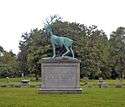
Greenlawn Cemetery |
|
000000001999-02-05-0000February 5, 1999
(#99000139) |
2700 Parish Ave.
36°59′50″N 76°24′15″W / 36.997222°N 76.404167°W / 36.997222; -76.404167 (Greenlawn Cemetery) |
|
| 12 |
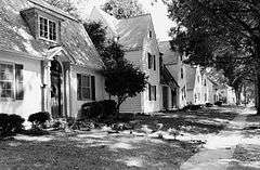
Hilton Village |
|
000000001969-06-23-0000June 23, 1969
(#69000341) |
Bounded by the James River, Post St., Chesapeake and Ohio RR tracks, and Hopkins St.
37°01′51″N 76°27′44″W / 37.030833°N 76.462222°W / 37.030833; -76.462222 (Hilton Village) |
|
| 13 |
Hotel Warwick |
|
000000001984-10-04-0000October 4, 1984
(#84000044) |
25th St. and West Ave.
36°58′36″N 76°25′55″W / 36.976667°N 76.431944°W / 36.976667; -76.431944 (Hotel Warwick) |
|
| 14 |
Matthew Jones House |
|
000000001969-06-11-0000June 11, 1969
(#69000342) |
Taylor Ave. and Harrison Rd., Fort Eustis
37°09′37″N 76°36′11″W / 37.160278°N 76.603056°W / 37.160278; -76.603056 (Matthew Jones House) |
|
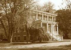
| 15 |
Lee Hall |
|
000000001972-12-05-0000December 5, 1972
(#72001510) |
Near jct. of U.S. 60 and VA 238
37°11′59″N 76°34′32″W / 37.199722°N 76.575556°W / 37.199722; -76.575556 (Lee Hall) |
|
| 16 |
Lee Hall Depot |
|
000000002010-09-24-0000September 24, 2010
(#10000793) |
9 Elmhurst St.
37°11′40″N 76°34′21″W / 37.194444°N 76.5725°W / 37.194444; -76.5725 (Lee Hall Depot) |
|
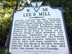
| 17 |
Lee's Mill Earthworks |
|
000000002003-06-23-0000June 23, 2003
(#03000568) |
280 Rivers Ridge Cir.
37°10′02″N 76°33′13″W / 37.167222°N 76.553611°W / 37.167222; -76.553611 (Lee's Mill Earthworks) |
|
| 18 |
Medical Arts Building |
|
000000002002-09-14-0000September 14, 2002
(#02001001) |
2901 West Avenue
36°58′47″N 76°26′04″W / 36.979722°N 76.434444°W / 36.979722; -76.434444 (Medical Arts Building) |
|
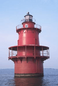
| 19 |
Newport News Middle Ground Light Station |
|
000000002002-12-02-0000December 2, 2002
(#02001438) |
Approx. 2 mi. SSE of Newport News
36°56′42″N 76°23′30″W / 36.945°N 76.391667°W / 36.945; -76.391667 (Newport News Middle Ground Light Station) |
|
| 20 |
Newport News Public Library |
|
000000002005-08-17-0000August 17, 2005
(#05000894) |
2907 West Ave.
36°58′55″N 76°26′04″W / 36.981944°N 76.434444°W / 36.981944; -76.434444 (Newport News Public Library) |
|
| 21 |
J. Thomas Newsome House |
|
000000001990-12-19-0000December 19, 1990
(#90001831) |
2803 Oak Ave.
36°59′23″N 76°24′18″W / 36.989722°N 76.405°W / 36.989722; -76.405 (J. Thomas Newsome House) |
|
| 22 |
Noland Company Building |
|
000000002010-05-21-0000May 21, 2010
(#10000283) |
2600 Warwick Blvd.
36°58′50″N 76°25′36″W / 36.980494°N 76.426714°W / 36.980494; -76.426714 (Noland Company Building) |
|
| 23 |
North End Historic District |
Upload image |
000000001986-08-28-0000August 28, 1986
(#86001999) |
Roughly bounded by Sixty-eighth St., Warwick Blvd., Fiftieth St., and Huntington Ave.
37°00′02″N 76°26′30″W / 37.000556°N 76.441667°W / 37.000556; -76.441667 (North End Historic District) |
|
| 24 |
Queen Hith Plantation Complex Site |
Upload image |
000000001983-02-24-0000February 24, 1983
(#83003293) |
Address Restricted
|
|
| 25 |
Richneck Plantation Site |
Upload image |
000000001977-07-08-0000July 8, 1977
(#77001535) |
Address Restricted
|
|
| 26 |
Riverside Apartments |
Upload image |
000000001983-07-28-0000July 28, 1983
(#83003294) |
4500-4600 Washington Ave.
36°59′28″N 76°26′20″W / 36.991111°N 76.438889°W / 36.991111; -76.438889 (Riverside Apartments) |
|
| 27 |
Skiffes Creek Sand Spit Site |
Upload image |
000000001983-02-24-0000February 24, 1983
(#83003295) |
Address Restricted
|
|
| 28 |
Smith's Pharmacy |
|
000000002002-06-06-0000June 6, 2002
(#02000618) |
3114 Chestnut Ave.
36°59′35″N 76°24′33″W / 36.993056°N 76.409167°W / 36.993056; -76.409167 (Smith's Pharmacy) |
|
| 29 |
Southern Terminal Redoubt |
Upload image |
000000001983-02-24-0000February 24, 1983
(#83003296) |
Address Restricted
|
|
| 30 |
St. Vincent de Paul Catholic Church |
|
000000002005-06-02-0000June 2, 2005
(#05000525) |
230 33rd St.
36°58′59″N 76°25′56″W / 36.983056°N 76.432222°W / 36.983056; -76.432222 (St. Vincent de Paul Catholic Church) |
|
| 31 |
Temple Sinai |
Upload image |
000000002015-05-18-0000May 18, 2015
(#15000252) |
11620 Warwick Blvd.
37°03′26″N 76°28′55″W / 37.0571°N 76.4819°W / 37.0571; -76.4819 (Temple Sinai) |
|
| 32 |
Warwick County Courthouses |
|
000000001988-11-03-0000November 3, 1988
(#88002186) |
Old Courthouse Way
37°07′47″N 76°32′33″W / 37.129722°N 76.5425°W / 37.129722; -76.5425 (Warwick County Courthouses) |
|
| 33 |
Whittaker Memorial Hospital |
|
000000002009-09-30-0000September 30, 2009
(#09000794) |
1003 28th St.
36°59′14″N 76°24′45″W / 36.987242°N 76.412572°W / 36.987242; -76.412572 (Whittaker Memorial Hospital) |
|

.jpg)
.JPG)
%2C_under_restoration.jpg)
.jpg)
.JPG)
.jpg)
.JPG)
.JPG)
.JPG)
.JPG)