| [3] |
Name on the Register[4] |
Image |
Date listed[5] |
Location |
City or town |
Description |
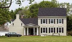
|---|
| 1 |
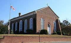
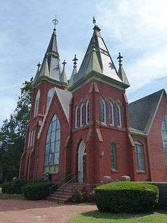
All Hallows Episcopal Church |
|
000000001979-08-06-0000August 6, 1979
(#79001148) |
101 N. Church St.
38°10′32″N 75°23′43″W / 38.17564°N 75.39523°W / 38.17564; -75.39523 (All Hallows Episcopal Church) |
Snow Hill |
|
| 2 |
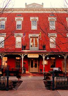
Berlin Commercial District |
|
000000001980-04-17-0000April 17, 1980
(#80001844) |
Main, Broad, Williams, Bay, Pitts, and Commerce Sts.
38°19′29″N 75°13′09″W / 38.324722°N 75.219167°W / 38.324722; -75.219167 (Berlin Commercial District) |
Berlin |
|
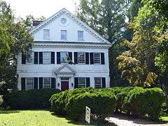
| 3 |
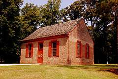
Beverly |
Upload image |
000000001975-10-29-0000October 29, 1975
(#75000933) |
4.5 miles southwest of Pocomoke City off Cedarhall Rd.
38°00′29″N 75°37′03″W / 38.008056°N 75.6175°W / 38.008056; -75.6175 (Beverly) |
Pocomoke City |
|
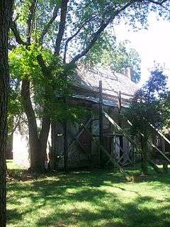
| 4 |
Buckingham Archeological Site |
|
000000001975-02-24-0000February 24, 1975
(#75000930) |
Address Restricted
|
Berlin |
|
| 5 |
Burley Manor |
Upload image |
000000001974-07-07-0000July 7, 1974
(#74000979) |
3 S. Main St.
38°19′10″N 75°13′10″W / 38.319444°N 75.219444°W / 38.319444; -75.219444 (Burley Manor) |
Berlin |
|
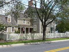
| 6 |
Caleb's Discovery |
|
000000001975-05-27-0000May 27, 1975
(#75000931) |
2 miles west of Berlin on U.S. Route 50
38°20′00″N 75°12′30″W / 38.333333°N 75.208333°W / 38.333333; -75.208333 (Caleb's Discovery) |
Berlin |
|
| 7 |
Chanceford |
|
000000001994-09-02-0000September 2, 1994
(#94001077) |
209 W. Federal St.
38°10′22″N 75°23′48″W / 38.172778°N 75.396667°W / 38.172778; -75.396667 (Chanceford) |
Snow Hill |
|
| 8 |
Littleton T. Clarke House |
|
000000001996-05-02-0000May 2, 1996
(#96000519) |
407 2nd St.
38°04′16″N 75°34′10″W / 38.071111°N 75.569444°W / 38.071111; -75.569444 (Littleton T. Clarke House) |
Pocomoke City |
|
| 9 |
Costen House |
|
000000001975-12-06-0000December 6, 1975
(#75000934) |
206 Market St.
38°04′29″N 75°34′04″W / 38.074722°N 75.567778°W / 38.074722; -75.567778 (Costen House) |
Pocomoke City |
|
| 10 |
Crockett House |
Upload image |
000000001996-03-21-0000March 21, 1996
(#96000299) |
900 Market St.
38°04′09″N 75°33′34″W / 38.069167°N 75.559444°W / 38.069167; -75.559444 (Crockett House) |
Pocomoke City |
|
| 11 |
Fassitt House |
Upload image |
000000001996-08-22-0000August 22, 1996
(#96000921) |
12025 Fassitt Ln.
38°17′09″N 75°08′47″W / 38.285833°N 75.146389°W / 38.285833; -75.146389 (Fassitt House) |
Berlin |
|
| 12 |
Old Friendship United Methodist Church |
Upload image |
000000001996-01-04-0000January 4, 1996
(#95001490) |
Meadow Bridge Rd.
38°13′25″N 75°35′13″W / 38.223611°N 75.586944°W / 38.223611; -75.586944 (Old Friendship United Methodist Church) |
Snow Hill |
|
| 13 |
Genesar |
|
000000001971-09-17-0000September 17, 1971
(#71000381) |
Southeast of Berlin on Maryland Route 611 off U.S. Route 50
38°14′07″N 75°11′22″W / 38.23521°N 75.1894°W / 38.23521; -75.1894 (Genesar) |
Berlin |
|
| 14 |
Samuel Gunn House |
|
000000002002-12-27-0000December 27, 2002
(#02001594) |
200 W. Market St.
38°10′32″N 75°23′46″W / 38.175556°N 75.396111°W / 38.175556; -75.396111 (Samuel Gunn House) |
Snow Hill |
|
| 15 |
Henry's Grove |
|
000000001984-09-13-0000September 13, 1984
(#84001891) |
Maryland Route 611
38°16′10″N 75°09′01″W / 38.269444°N 75.150278°W / 38.269444; -75.150278 (Henry's Grove) |
Berlin |
|
| 16 |
Makemie Memorial Presbyterian Church |
|
000000002008-11-10-0000November 10, 2008
(#08001044) |
103 W. Market St.
38°10′38″N 75°23′37″W / 38.177152°N 75.393478°W / 38.177152; -75.393478 (Makemie Memorial Presbyterian Church) |
Snow Hill |
|
| 17 |
Mansion House |
Upload image |
000000001995-01-19-0000January 19, 1995
(#94001643) |
Bayside Rd.
38°08′54″N 75°17′15″W / 38.148333°N 75.2875°W / 38.148333; -75.2875 (Mansion House) |
Public Landing |
|
| 18 |
Mar-Va Theater |
|
000000001996-03-21-0000March 21, 1996
(#96000301) |
103 Market St.
38°04′33″N 75°34′09″W / 38.075833°N 75.569167°W / 38.075833; -75.569167 (Mar-Va Theater) |
Pocomoke City |
|
| 19 |
James Martin House |
Upload image |
000000001996-08-22-0000August 22, 1996
(#96000922) |
207 Ironshire St.
38°10′15″N 75°23′41″W / 38.170833°N 75.394722°W / 38.170833; -75.394722 (James Martin House) |
Snow Hill |
|
| 20 |
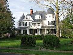
Merry Sherwood |
Upload image |
000000001991-09-20-0000September 20, 1991
(#91001420) |
8909 Worcester Highway
38°18′20″N 75°13′23″W / 38.305556°N 75.223056°W / 38.305556; -75.223056 (Merry Sherwood) |
Berlin |
|
| 21 |
Nassawango Iron Furnace Site |
|
000000001975-10-31-0000October 31, 1975
(#75000935) |
On Old Furnace Road, northwest of Snow Hill off Maryland Route 12
38°12′15″N 75°28′08″W / 38.204167°N 75.468889°W / 38.204167; -75.468889 (Nassawango Iron Furnace Site) |
Snow Hill |
|
| 22 |
Nun's Green |
Upload image |
000000001979-09-20-0000September 20, 1979
(#79003263) |
South of Snow Hill on Cherrix Rd.
38°07′49″N 75°22′57″W / 38.130278°N 75.3825°W / 38.130278; -75.3825 (Nun's Green) |
Snow Hill |
|
| 23 |
Pocomoke City Historic District |
|
000000002004-12-23-0000December 23, 2004
(#04001383) |
Market, Cedar, 2nd, Clarke, and Bridge Sts. and Linden Ave.
38°04′24″N 75°33′57″W / 38.073333°N 75.565833°W / 38.073333; -75.565833 (Pocomoke City Historic District) |
Pocomoke City |
|
| 24 |
George Washington Purnell House |
Upload image |
000000001996-08-22-0000August 22, 1996
(#96000920) |
201 E. Market St.
38°10′40″N 75°23′33″W / 38.177778°N 75.3925°W / 38.177778; -75.3925 (George Washington Purnell House) |
Snow Hill |
|
| 25 |
Queponco Railway Station |
Upload image |
000000001996-01-19-0000January 19, 1996
(#95001546) |
2378 Patey Woods Rd.
38°15′05″N 75°17′34″W / 38.251389°N 75.292778°W / 38.251389; -75.292778 (Queponco Railway Station) |
Newark |
|
| 26 |
Sandy Point Site |
|
000000001975-04-28-0000April 28, 1975
(#75000932) |
Address Restricted
|
Ocean City |
|
| 27 |
Simpson's Grove |
|
000000001996-08-30-0000August 30, 1996
(#96000949) |
Eastern side of Downs Rd., approximately 2 miles southwest of the junction of U.S. Routes 50 and 113
38°16′42″N 75°14′53″W / 38.278333°N 75.248056°W / 38.278333; -75.248056 (Simpson's Grove) |
Ironshire |
|
| 28 |
Gov. John Walter Smith House |
|
000000001994-09-15-0000September 15, 1994
(#94001146) |
104 S. Church St.
38°10′23″N 75°23′41″W / 38.173056°N 75.394722°W / 38.173056; -75.394722 (Gov. John Walter Smith House) |
Snow Hill |
|
| 29 |
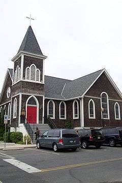
St. Martins Church |
|
000000001977-04-13-0000April 13, 1977
(#77000707) |
1 mile south of Showell at the junction of U.S. Route 113 and Maryland Route 589
38°23′34″N 75°12′18″W / 38.392778°N 75.205°W / 38.392778; -75.205 (St. Martins Church) |
Showell |
|
| 30 |
St. Paul's by-the-sea Protestant Episcopal Church |
|
000000002008-10-22-0000October 22, 2008
(#08001013) |
302 N. Baltimore St.
38°20′05″N 75°05′05″W / 38.334722°N 75.084722°W / 38.334722; -75.084722 (St. Paul's by-the-sea Protestant Episcopal Church) |
Ocean City |
|
| 31 |
Williams Grove |
Upload image |
000000001996-08-22-0000August 22, 1996
(#96000919) |
11842 Porfin Dr.
38°15′40″N 75°09′16″W / 38.261111°N 75.154444°W / 38.261111; -75.154444 (Williams Grove) |
Berlin |
|
| 32 |
Young-Sartorius House |
|
000000001996-08-30-0000August 30, 1996
(#96000948) |
405 Market St.
38°04′25″N 75°33′57″W / 38.073611°N 75.565833°W / 38.073611; -75.565833 (Young-Sartorius House) |
Pocomoke City |
|

.jpg)
.jpg)
.jpg)
.jpg)

.jpg)
.jpg)
.jpg)