| [3] |
Name on the Register |
Image |
Date listed[4] |
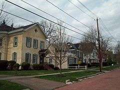
Location |
City or town |
Description |
|---|
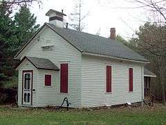
| 1 |
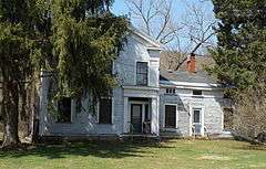
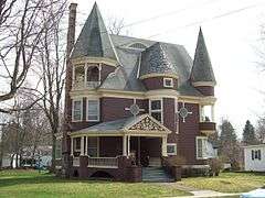
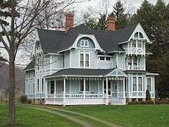
John J. Aiken House |
|
000000002013-02-20-0000February 20, 2013
(#13000025) |
6805 Poverty Hill Rd.
42°18′00″N 78°41′01″W / 42.299881°N 78.683592°W / 42.299881; -78.683592 (John J. Aiken House) |
Ellicottville |
|
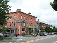
| 2 |
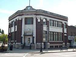
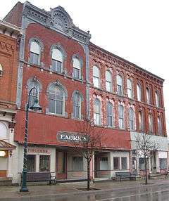
Bank of Gowanda |
|
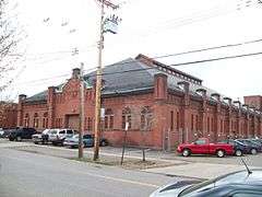
000000002001-05-25-0000May 25, 2001
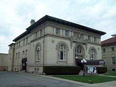
(#01000553) |
8 W. Main St.
42°27′45″N 78°56′10″W / 42.4625°N 78.936111°W / 42.4625; -78.936111 (Bank of Gowanda) |
Gowanda |
|
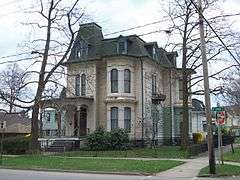
| 3 |
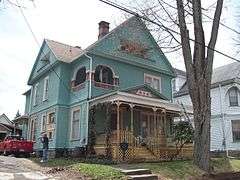
Beardsley-Oliver House |
|
000000002008-02-28-0000February 28, 2008
(#08000097) |
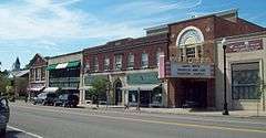
312 Laurel Ave.
42°04′42″N 78°25′36″W / 42.078333°N 78.426667°W / 42.078333; -78.426667 (Beardsley-Oliver House) |
Olean |
|
| 4 |
Bedford Corners Historic District |
|
000000002003-07-05-0000July 5, 2003
(#03000590) |
NY 305 at Deer Creek and Dodge Creek Rds.
42°03′14″N 78°18′38″W / 42.053889°N 78.310556°W / 42.053889; -78.310556 (Bedford Corners Historic District) |
Portville |
|
| 5 |
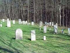
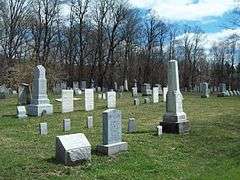
Bryant Hill Cemetery |
|
000000002003-07-05-0000July 5, 2003
(#03000605) |
Bryant Hill Rd. near Crane Rd.
42°18′19″N 78°36′07″W / 42.305278°N 78.601944°W / 42.305278; -78.601944 (Bryant Hill Cemetery) |
Ellicottville |
|
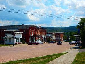
| 6 |
Cattaraugus Village Commercial Historic District |
|
000000002014-01-15-0000January 15, 2014
(#13001113) |
9-52 Main, 1-17 Washington, 14 Waverly Sts.
42°19′47″N 78°52′04″W / 42.32977°N 78.867672°W / 42.32977; -78.867672 (Cattaraugus Village Commercial Historic District) |
Cattaraugus |
Core of small village
|
| 7 |
Conklin Mountain House |
|
000000001998-11-19-0000November 19, 1998
(#98001386) |
304 E. State St.
42°04′38″N 78°25′33″W / 42.077222°N 78.425833°W / 42.077222; -78.425833 (Conklin Mountain House) |
Olean |
|
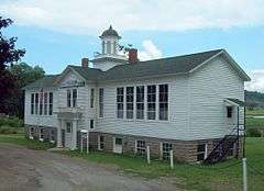
| 8 |
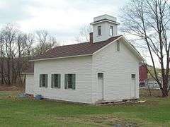
East Otto Union School |
|
000000002004-09-15-0000September 15, 2004
(#04000993) |
9014 East Otto-Springville Rd.
42°23′28″N 78°45′16″W / 42.391111°N 78.754444°W / 42.391111; -78.754444 (East Otto Union School) |
East Otto |
|
| 9 |
Ellicottville Historic District |
|
000000001991-08-22-0000August 22, 1991
(#91001028) |
Roughly bounded by Elizabeth, Monroe, Martha and Adams Sts.
42°16′30″N 78°40′23″W / 42.274883°N 78.673172°W / 42.274883; -78.673172 (Ellicottville Historic District) |
Ellicottville |
|
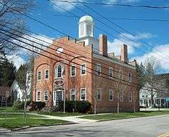
| 10 |
Ellicottville Town Hall |
|
000000001973-04-03-0000April 3, 1973
(#73001166) |
Village Sq., NW corner of Washington and Jefferson Sts.
42°16′31″N 78°40′25″W / 42.275278°N 78.673611°W / 42.275278; -78.673611 (Ellicottville Town Hall) |
Ellicottville |
|
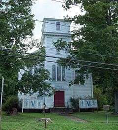
| 11 |
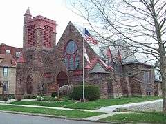
First Congregational Church of Otto |
|
000000001999-02-12-0000February 12, 1999
(#99000194) |
9019 Main St.
42°21′19″N 78°49′40″W / 42.355278°N 78.827778°W / 42.355278; -78.827778 (First Congregational Church of Otto) |
Otto |
|
| 12 |
Gladden Windmill |
|
000000001973-07-16-0000July 16, 1973
(#73001167) |
Pigeon Valley Rd.
42°14′07″N 78°53′44″W / 42.235278°N 78.895556°W / 42.235278; -78.895556 (Gladden Windmill) |
Napoli |
|
| 13 |
Gowanda Village Historic District |
|
000000001986-09-22-0000September 22, 1986
(#86002691) |
37, 39, 41-45, 47-49, and 53 W. Main St.
42°27′47″N 78°56′12″W / 42.463056°N 78.936667°W / 42.463056; -78.936667 (Gowanda Village Historic District) |
Gowanda |
|
| 14 |
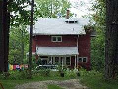
House at 520 Hostageh Road |
|
000000002009-02-20-0000February 20, 2009
(#09000038) |
520 Ho-Sta-Geh Road
42°00′53″N 78°28′17″W / 42.014672°N 78.471428°W / 42.014672; -78.471428 (House at 520 Hostageh Road) |
Rock City |
|
| 15 |
Jefferson Street Cemetery |
|
000000002012-01-04-0000January 4, 2012
(#11000994) |
East side of Jefferson St. between Martha St. & Aspen Dr.
42°16′13″N 78°40′07″W / 42.270278°N 78.668611°W / 42.270278; -78.668611 (Jefferson Street Cemetery) |
Ellicottville |
|
| 16 |
Leon Grange No. 795 |
Upload image |
000000002014-01-15-0000January 15, 2014
(#13001089) |
US 62 near Leon–New Albion Rd.
42°17′39″N 79°01′00″W / 42.29403574685556°N 79.01663128517664°W / 42.29403574685556; -79.01663128517664 (Leon Grange No. 795) |
Leon |
|
| 17 |
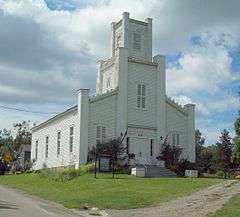
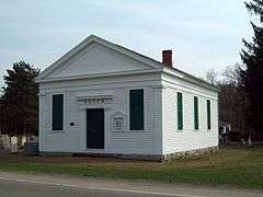
Leon United Methodist Church |
|
000000002000-11-22-0000November 22, 2000
(#00001413) |
Junction of Cattaraugus Co. 6 and U.S. Route 62
42°17′36″N 79°01′03″W / 42.293333°N 79.0175°W / 42.293333; -79.0175 (Leon United Methodist Church) |
Leon |
|
| 18 |
North Lyndon Schoolhouse |
|
000000002000-09-15-0000September 15, 2000
(#00000571) |
7617 North Center Rd.
42°19′51″N 78°21′16″W / 42.330833°N 78.354444°W / 42.330833; -78.354444 (North Lyndon Schoolhouse) |
Lyndon |
|
| 19 |
Oak Hill Park Historic District |
|
000000001997-12-01-0000December 1, 1997
(#97001495) |
Roughly along Laurens, N. Second, Third, Fourth, and W. Sullivan Sts.
42°04′50″N 78°26′04″W / 42.080556°N 78.434444°W / 42.080556; -78.434444 (Oak Hill Park Historic District) |
Olean |
|
| 20 |
Olean Armory |
|
000000001995-03-02-0000March 2, 1995
(#95000080) |
119 Times Sq.
42°04′41″N 78°25′43″W / 42.078056°N 78.428611°W / 42.078056; -78.428611 (Olean Armory) |
Olean |
|
| 21 |
Olean Public Library |
|
000000001985-07-11-0000July 11, 1985
(#85001498) |
116 S. Union St.
42°04′36″N 78°25′50″W / 42.076667°N 78.430556°W / 42.076667; -78.430556 (Olean Public Library) |
Olean |
|
| 22 |
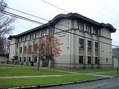
Olean School No. 10 |
|
000000002010-10-01-0000October 1, 2010
(#10000810) |
411 W. Henley St.
42°04′32″N 78°26′04″W / 42.075556°N 78.434444°W / 42.075556; -78.434444 (Olean School No. 10) |
Olean |
|
| 23 |
Park Square Historic District |
|
000000001986-09-22-0000September 22, 1986
(#86002719) |
Park Square roughly bounded by N. Main, Pine, Chestnut, S. Main, Elm, and Church Sts.
42°20′14″N 78°27′27″W / 42.337222°N 78.4575°W / 42.337222; -78.4575 (Park Square Historic District) |
Franklinville |
|
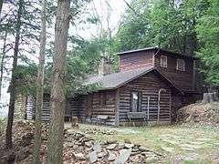
| 24 |
Pfeiffer-Wheeler American Chestnut Cabin |
|
000000002002-01-11-0000January 11, 2002
(#01001436) |
Lillibridge Rd.
42°05′34″N 78°19′29″W / 42.092778°N 78.324722°W / 42.092778; -78.324722 (Pfeiffer-Wheeler American Chestnut Cabin) |
Portville |
|
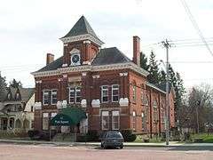
| 25 |
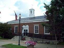
Portville Free Library |
|
000000001991-11-07-0000November 7, 1991
(#91001671) |
2 N. Main St.
42°02′20″N 78°20′25″W / 42.038889°N 78.340278°W / 42.038889; -78.340278 (Portville Free Library) |
Portville |
|
| 26 |
Randolph Historic District |
|
000000002012-12-12-0000December 12, 2012
(#12001035) |
Junction of Main & Jamestown to Borden Sts.
42°09′49″N 78°58′50″W / 42.163594°N 78.980457°W / 42.163594; -78.980457 (Randolph Historic District) |
Randolph |
|
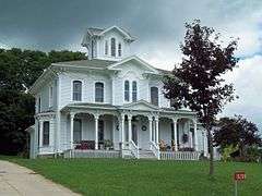
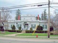
| 27 |
Simeon B. Robbins House |
|
000000002003-03-07-0000March 7, 2003
(#03000091) |
9 Pine St.
42°20′16″N 78°27′23″W / 42.337778°N 78.456389°W / 42.337778; -78.456389 (Simeon B. Robbins House) |
Franklinville |
|
| 28 |
St. Stephen's Episcopal Church Complex |
|
000000002001-01-26-0000January 26, 2001
(#00001684) |
109 S. Barry St.
42°04′36″N 78°25′40″W / 42.076667°N 78.427778°W / 42.076667; -78.427778 (St. Stephen's Episcopal Church Complex) |
Olean |
|
| 29 |
Salem Welsh Church |
|
000000001995-09-07-0000September 7, 1995
(#95001065) |
11141 NY 98 at junction with Galen Hill Rd.
42°29′12″N 78°21′31″W / 42.486667°N 78.358611°W / 42.486667; -78.358611 (Salem Welsh Church) |
Freedom |
|
| 30 |
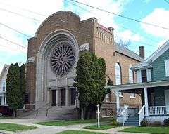
Temple B'Nai Israel |
|
000000002012-01-04-0000January 4, 2012
(#11000995) |
127 S. Barry St.
42°04′35″N 78°25′39″W / 42.07625°N 78.427536°W / 42.07625; -78.427536 (Temple B'Nai Israel) |
Olean |
|
| 31 |
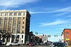
Union and State Streets Historic District |
|
000000002015-05-21-0000May 21, 2015
(#15000265) |
Roughly 101-133 N. Union, 110-114, 116 W. State & 102, 116, 120 S. Union Sts.
42°04′40″N 78°25′59″W / 42.077827°N 78.4329487°W / 42.077827; -78.4329487 (Union and State Streets Historic District) |
Olean |
Intact core of downtown commercial area, with buildings from post-Civil War era to pre-World War II
|
| 32 |
US Post Office-Little Valley |
|
000000001989-05-11-0000May 11, 1989
(#88002344) |
115 Main St.
42°14′57″N 78°47′55″W / 42.249167°N 78.798611°W / 42.249167; -78.798611 (US Post Office-Little Valley) |
Little Valley |
|
| 33 |
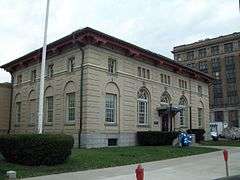
US Post Office-Olean |
|
000000001989-05-11-0000May 11, 1989
(#88002388) |
102 S. Union St.
42°04′37″N 78°25′50″W / 42.076944°N 78.430556°W / 42.076944; -78.430556 (US Post Office-Olean) |
Olean |
|
| 34 |
William E. Wheeler House |
|
000000002002-01-11-0000January 11, 2002
(#01001435) |
29 Maple Ave.
42°02′26″N 78°20′21″W / 42.040556°N 78.339167°W / 42.040556; -78.339167 (William E. Wheeler House) |
Portville |
|